METAR & TAF 75J
75J does not publish a METAR.
Showing the nearest reporting station: KTMA (HENRY TIFT MYERS) · 17.2 NM away. Conditions at 75J may differ.
METAR · KTMA
Observed 05:35Z
KTMA 270535Z AUTO 28005KT 10SM VCTS CLR 27/26 A2994 RMK AO2 T02690262 $
- Wind
- 280° @ 5 kt
- Visibility
- 10 SM
- Temp / Dew
- 27°C / 26°C
- Altimeter
- 29.94 inHg
- Clouds
- CLR
- Density alt
- 1,897 ft
- Ceiling
- Unlimited
- Rules
- VFR
Airport info & contacts
Manager on record, flight service, ARTCC, attendance schedule and pattern altitude — published by the FAA and refreshed every 28 days.
Location
- From city
- 2 NM SE
- VFR sectional
- JACKSONVILLE
- ARTCC
- ZJX · JACKSONVILLE
- NOTAM facility
- MCN (NOTAM-D)
Airport manager
- Name
- ERIC RICHTER
- Phone
- 229-425-1791
- Address
- 171 FREEMAN RD, REBECCA GA 31783
Flight service · Hours
- FSS MCN
- MACON1-800-WX-BRIEF
- Attendance
- Unattended
Frequencies
Tap any row to copy the frequency to your clipboard.
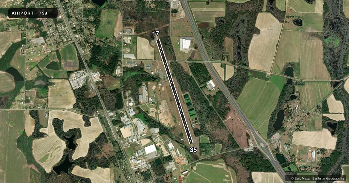
Runways & pattern
Full pagePattern entry · RWY 35
LEFT TRAFFICRunway end performance
| End | TORA | TODA | ASDA | LDA | VGSI | Approach lights | Obstruction |
|---|---|---|---|---|---|---|---|
| 17 | — | — | — | — | — | — | 17', trees, 555' from thr, 283' R of cntrln, slope 20 |
| 35 | — | — | — | — | — | — | 51', trees, 627' from thr, 299' R of cntrln, slope 8 |
Declared distances in feet. TORA = takeoff run available, TODA = takeoff distance, ASDA = accelerate-stop, LDA = landing distance.
Airport sketch
Runways drawn to scale from FAA survey coordinates, rendered over satellite imagery. Not for navigation.
Approaches & charts
Services on the field
Fuel grades, oxygen, maintenance, ramp storage and lighting — as declared to the FAA by the airport operator.
Fuel & services
- Fuel
- Not available
- Oxygen (bottled)
- Not available
- Oxygen (bulk)
- Not available
- Airframe repair
- Not available
- Power plant repair
- Not available
- Other services
- AGRI
Ramp & ground
- Transient storage
- Tie-down
- Landing fee
- No fee published
- Customs
- Not available
- Lighting schedule
- SEE RMK
- Beacon schedule
- SS-SR
- Beacon
- White / Green (civil land)(WG)
- Wind indicator
- Lighted
- Segmented circle
- Yes
Fuel & FBOs
Cheapest 100LL and Jet A on the field and nearby. Always confirm with the FBO before taxi.
Airport notes
Surface conditions, obstructions, local procedures, lighting outages and other notes published with each FAA cycle.
General notes
- FOR CD CTC VALDOSTA APCH AT 229-257-2207, WHEN APCH CLSD CTC JACKSONVILLE ARTCC AT 904-845-1592.
Lighting notes
- ROTG BCN LCTD ON WATER TANK 1/4 MILE NW OF ARPT.
- MIRL RWY 17/35 OPR DUSK-0000. OTR TIMES - CTAF.
VFR map & nearby airports
VFR sectional. Tap any ICAO chip to open that airport.
Key facts · 75J
Answer card- ICAO
- 75J
- Name
- TURNER COUNTY
- Location
- ASHBURN, GEORGIA
- Elevation
- 388.9 ft MSL
- Traffic pattern altitude
- 1,388.9 ft MSL (1,000 AGL)
- Control tower
- Non-towered (use CTAF)
- Total runways
- 1
- Longest runway
- 17/35 · 5,005 ft
- Published ILS approaches
- 0
- Published frequencies
- 2
- Magnetic variation
- 6°
- Current flight rules
- VFR
- Current wind
- 280° at 5 kt
- Favored runway now
- RWY 35
Turner County Airport sits in Ashburn, Georgia. The field elevation is 388.9 ft MSL. It has one runway. Runway 17/35 is 5,005 ft of asphalt. There is no control tower. CTAF and UNICOM are both 122.7. No ILS approaches are published here.
Pattern altitude is not published. Use 1,000 ft AGL for light piston traffic unless the current Chart Supplement says otherwise. The published remarks also note that clearance delivery goes through Valdosta Approach at 229-257-2207. When approach is closed, contact Jacksonville ARTCC at 904-845-1592. The rotating beacon sits on a water tank about a quarter mile northwest of the airport. Medium intensity runway lights on 17/35 operate from dusk to midnight. After that, use the common traffic advisory frequency for lighting needs.
No on-field FBOs are listed in the facts provided. Contact the airport operator directly or call the field on CTAF for current service status before you go. For a first-time arrival, plan for an uncontrolled field with a single runway and no published ILS. Check the current Chart Supplement for any noise or curfew restrictions before flying into the field.