METAR & TAF KTMA
Current METAR
Observed 13:35Z
KTMA 271335Z AUTO 30006KT 10SM CLR 29/27 A2993 RMK AO2 T02930273 $
- Wind
- 300° @ 6 kt
- Visibility
- 10 SM
- Temp / Dew
- 29°C / 27°C
- Altimeter
- 29.93 inHg
- Clouds
- CLR
- Density alt
- 2,107 ft
- Ceiling
- Unlimited
- Rules
- VFR
Airport info & contacts
Manager on record, flight service, ARTCC, attendance schedule and pattern altitude — published by the FAA and refreshed every 28 days.
Location
- From city
- 2 NM SE
- VFR sectional
- JACKSONVILLE
- ARTCC
- ZJX · JACKSONVILLE
- NOTAM facility
- MCN (NOTAM-D)
Airport manager
- Name
- ERIC RICHTER
- Phone
- 229-425-1791
- Address
- 3093 US HIGHWAY 41 S, TIFTON GA 31794
Flight service · Hours
- FSS MCN
- MACON1-800-WX-BRIEF
- Attendance
- MON-FRI · 0700-1700
- SAT-SUN · 0800-1700
Frequencies
Tap any row to copy the frequency to your clipboard.
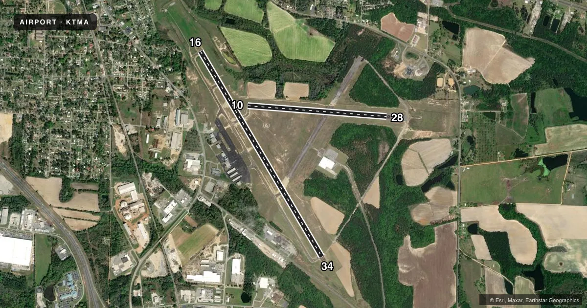
Runways & pattern
Full pagePattern entry · RWY 28
LEFT TRAFFIC| Runway | Heading (°M) | Length | Surface | Traffic |
|---|---|---|---|---|
| 16/34 | 146° / 326° | 6,506 ft | ASPH | Standard L |
| 10/28Favored | 91° / 271° | 3,807 ft | ASPH | Standard L |
Runway end performance
| End | TORA | TODA | ASDA | LDA | VGSI | Approach lights | Obstruction |
|---|---|---|---|---|---|---|---|
| 16 | — | — | — | — | PAPI 4-box left(3°) | — | 20', pole, 260' from thr, 400' R of cntrln, slope 3 |
| 34 | — | — | — | — | PAPI 4-box left(3°) | MALSR | 58', trees, 722' from thr, 549' R of cntrln, slope 9 |
Declared distances in feet. TORA = takeoff run available, TODA = takeoff distance, ASDA = accelerate-stop, LDA = landing distance.
Airport sketch
Runways drawn to scale from FAA survey coordinates, rendered over satellite imagery. Not for navigation.
Approaches & charts
ILS · 1
Services on the field
Fuel grades, oxygen, maintenance, ramp storage and lighting — as declared to the FAA by the airport operator.
Fuel & services
- Fuel
- 100LLA+
- Oxygen (bottled)
- Not available
- Oxygen (bulk)
- Not available
- Airframe repair
- Major
- Power plant repair
- Major
- Other services
- INSTR
Ramp & ground
- Transient storage
- Tie-down
- Landing fee
- No fee published
- Customs
- Not available
- Lighting schedule
- SEE RMK
- Beacon schedule
- SS-SR
- Beacon
- White / Green (civil land)(WG)
- Wind indicator
- Lighted
- Segmented circle
- Yes
Fuel & FBOs
Cheapest 100LL and Jet A on the field and nearby. Always confirm with the FBO before taxi.
Airport notes
Surface conditions, obstructions, local procedures, lighting outages and other notes published with each FAA cycle.
General notes
- (E99) USED FOR MAINT.
Lighting notes
- ACTVT HIRL RWY 16/34, PAPI RWYS 16 AND 34, MALSR RWY 34 - CTAF.
Fuel notes
- 100LLFUEL 24 HR CREDIT CARD SVC AVBL.
Approach & departure obstructions
- 1640 FT TREE, 190 FT FM EOR, 491 FT RIGHT.
Other notes
- EXISTED PRIOR TO 1959.
- 5AFTER HRS SVC: 229-382-2545.
- MANAGERCHAIRMAN HENRY TIFT MYERS AIRPORT AUTHORITY.
VFR map & nearby airports
VFR sectional. Tap any ICAO chip to open that airport.
Key facts · KTMA
Answer card- ICAO
- KTMA
- Name
- HENRY TIFT MYERS
- Location
- TIFTON, GEORGIA
- Elevation
- 354.6 ft MSL
- Traffic pattern altitude
- 1,354.6 ft MSL (1,000 AGL)
- Control tower
- Non-towered (use CTAF)
- Total runways
- 2
- Longest runway
- 16/34 · 6,506 ft
- Published ILS approaches
- 1
- Published frequencies
- 5
- Magnetic variation
- 3°
- Current flight rules
- VFR
- Current wind
- 300° at 6 kt
- Favored runway now
- RWY 28
Henry Tift Myers is in Tifton, Georgia. The field elevation is 354.6 ft MSL. It has two asphalt runways. The longest is runway 16/34 at 6,506 ft. Runway 10/28 is 3,807 ft. There is no control tower, so use CTAF 122.7 and keep a close scan for local traffic. The published pattern altitude is not listed. Use the standard 1,000 ft AGL for light piston traffic unless the current Chart Supplement says otherwise.
Runway 34 has the ILS. The published remarks also note PAPI on runways 16 and 34. High intensity runway lighting is installed on 16/34. There is also a medium intensity approach lighting system with runway alignment indicator lights for runway 34. A tree is published near the departure end of runway 16. That is worth checking before a departure on that end.
Richter Aviation is on the field. It carries 100LL and Jet A. Fuel is available 24 hours with credit card service. After-hours service is available by phone. This field is used for maintenance. First-time arrivals should plan for an uncontrolled airport with a long primary runway. It has published instrument capability on 34. Local traffic will be on the common advisory frequency.