METAR & TAF 4J2
4J2 does not publish a METAR.
Showing the nearest reporting station: KTMA (HENRY TIFT MYERS) · 18.8 NM away. Conditions at 4J2 may differ.
METAR · KTMA
Observed 12:35Z
KTMA 271235Z AUTO 29005KT 10SM CLR 27/27 A2993 RMK AO2 T02700267 $
- Wind
- 290° @ 5 kt
- Visibility
- 10 SM
- Temp / Dew
- 27°C / 27°C
- Altimeter
- 29.93 inHg
- Clouds
- CLR
- Density alt
- 1,725 ft
- Ceiling
- Unlimited
- Rules
- VFR
Airport info & contacts
Manager on record, flight service, ARTCC, attendance schedule and pattern altitude — published by the FAA and refreshed every 28 days.
Location
- From city
- 1 NM E
- VFR sectional
- JACKSONVILLE
- ARTCC
- ZJX · JACKSONVILLE
- NOTAM facility
- MCN (NOTAM-D)
Airport manager
- Name
- BRENDA FERRELL
- Phone
- 229-686-5421
- Address
- 201 N DAVIS STREET, ROOM 198, NASHVILLE GA 31639
Flight service · Hours
- FSS MCN
- MACON1-800-WX-BRIEF
- Attendance
- UNATTENDED
Frequencies
Tap any row to copy the frequency to your clipboard.
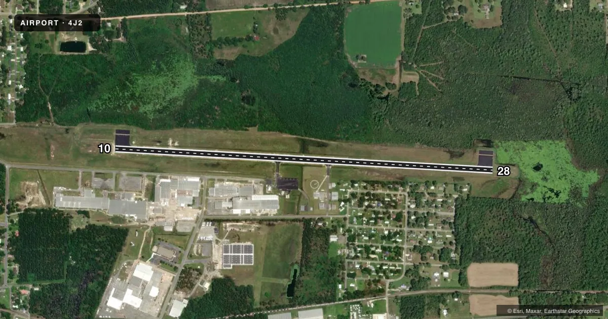
Runways & pattern
Full pagePattern entry · RWY 28
LEFT TRAFFICRunway end performance
| End | TORA | TODA | ASDA | LDA | VGSI | Approach lights | Obstruction |
|---|---|---|---|---|---|---|---|
| 10 | — | — | — | — | PAPI 4-box left(3°) | — | 28', trees, 582' from thr, 306' R of cntrln, slope 13 |
| 28 | — | — | — | — | PAPI 4-box left(3°) | — | 87', trees, 2375' from thr, 552' R of cntrln, slope 25 |
Declared distances in feet. TORA = takeoff run available, TODA = takeoff distance, ASDA = accelerate-stop, LDA = landing distance.
Airport sketch
Runways drawn to scale from FAA survey coordinates, rendered over satellite imagery. Not for navigation.
Approaches & charts
Services on the field
Fuel grades, oxygen, maintenance, ramp storage and lighting — as declared to the FAA by the airport operator.
Fuel & services
- Fuel
- A
- Oxygen (bottled)
- Not available
- Oxygen (bulk)
- Not available
- Airframe repair
- Not available
- Power plant repair
- Not available
- Other services
- AGRI
Ramp & ground
- Transient storage
- Tie-down
- Landing fee
- No fee published
- Customs
- Not available
- Lighting schedule
- SEE RMK
- Beacon schedule
- SS-SR
- Beacon
- White / Green (civil land)(WG)
- Wind indicator
- Lighted
- Segmented circle
- Yes
Fuel & FBOs
Cheapest 100LL and Jet A on the field and nearby. Always confirm with the FBO before taxi.
Airport notes
Surface conditions, obstructions, local procedures, lighting outages and other notes published with each FAA cycle.
General notes
- FOR CD CTC JACKSONVILLE ARTCC AT 904-845-1592.
Lighting notes
- MIRL 10/28 PRESET LOW INTST DUSK-DAWN; TO INCREASE INTST AND ACTVT REIL RWY 10 & 28; PAPI RWY 10 & 28 - CTAF.
VFR map & nearby airports
VFR sectional. Tap any ICAO chip to open that airport.
Key facts · 4J2
Answer card- ICAO
- 4J2
- Name
- BERRIEN COUNTY
- Location
- NASHVILLE, GEORGIA
- Elevation
- 240.1 ft MSL
- Traffic pattern altitude
- 1,240.1 ft MSL (1,000 AGL)
- Control tower
- Non-towered (use CTAF)
- Total runways
- 1
- Longest runway
- 10/28 · 5,002 ft
- Published ILS approaches
- 0
- Published frequencies
- 5
- Magnetic variation
- 3°
- Current flight rules
- VFR
- Current wind
- 290° at 5 kt
- Favored runway now
- RWY 28
Berrien County Airport sits in Nashville, Georgia. Field elevation is 240.1 ft MSL. The airport has one runway, 10/28, which is 5,002 ft long. There is no control tower. No ILS approaches are published here.
The pattern altitude is not published. For light piston operations, plan on the standard 1,000 ft AGL pattern unless the current Chart Supplement says otherwise. Runway 10/28 has medium intensity lights. They are preset to low intensity from dusk to dawn. Use CTAF 122.7 to raise intensity. The same frequency also activates the runway end identifier lights and the PAPI on both ends.
No on-field FBOs are listed, so verify fuel and services with the airport operator or the FBO directly by phone before you go. Published remarks also say clearance delivery is handled through Jacksonville ARTCC at 904-845-1592. That is useful if you need a clearance before departure. With no published ILS and a single runway, this is a straightforward field. Still, check the current Chart Supplement for any noise or operating notes before flying in.