METAR & TAF KMGR
Current METAR
Observed 13:35Z
KMGR 271335Z AUTO 30004KT 8SM CLR 29/27 A2993 RMK AO2 T02890265 $
- Wind
- 300° @ 4 kt
- Visibility
- 8 SM
- Temp / Dew
- 29°C / 27°C
- Altimeter
- 29.93 inHg
- Clouds
- CLR
- Density alt
- 2,036 ft
- Ceiling
- Unlimited
- Rules
- VFR
Airport info & contacts
Manager on record, flight service, ARTCC, attendance schedule and pattern altitude — published by the FAA and refreshed every 28 days.
Location
- From city
- 6 NM S
- VFR sectional
- JACKSONVILLE
- ARTCC
- ZJX · JACKSONVILLE
- NOTAM facility
- MCN (NOTAM-D)
Airport manager
- Name
- ALAN MATHIS
- Phone
- 229-890-9464
- Address
- 189 AIRPORT DRIVE, MOULTRIE GA 31768
Flight service · Hours
- FSS MCN
- MACON1-800-WX-BRIEF
- Attendance
- 0730-DUSK
Frequencies
Tap any row to copy the frequency to your clipboard.
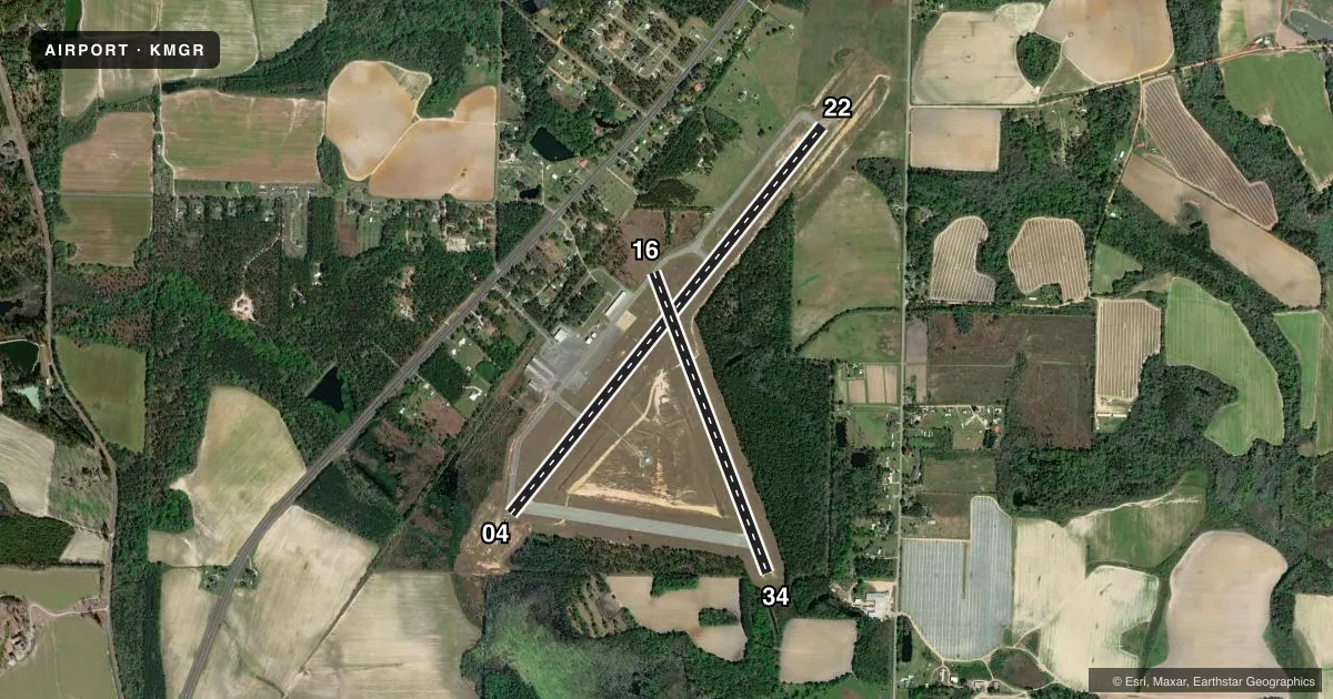
Runways & pattern
Full pagePattern entry · RWY 34
LEFT TRAFFIC| Runway | Heading (°M) | Length | Surface | Traffic |
|---|---|---|---|---|
| 04/22 | 34° / 214° | 6,000 ft | ASPH | Standard L |
| 16/34Favored | 154° / 334° | 3,878 ft | ASPH | Standard L |
Runway end performance
| End | TORA | TODA | ASDA | LDA | VGSI | Approach lights | Obstruction |
|---|---|---|---|---|---|---|---|
| 04 | 6,000' | 6,000' | 6,000' | 6,000' | PAPI 2-box left(3°) | — | 25', trees, 725' from thr, 301' R of cntrln, slope 21 |
| 22 | 6,000' | 6,000' | 6,000' | 5,628' | PAPI 2-box left(3°) | — | 89', trees, 1980' from thr, 414' R of cntrln, slope 20 |
| 16 | — | — | — | — | — | — | 72', trees, 992' from thr, 203' R of cntrln, slope 11 |
| 34 | — | — | — | — | — | — | 9', trees, 281' from thr, 0' R of cntrln, slope 9 |
Declared distances in feet. TORA = takeoff run available, TODA = takeoff distance, ASDA = accelerate-stop, LDA = landing distance.
Airport sketch
Runways drawn to scale from FAA survey coordinates, rendered over satellite imagery. Not for navigation.
Approaches & charts
Services on the field
Fuel grades, oxygen, maintenance, ramp storage and lighting — as declared to the FAA by the airport operator.
Fuel & services
- Fuel
- 100LLA+
- Oxygen (bottled)
- HIGH/LOW
- Oxygen (bulk)
- Not available
- Airframe repair
- Major
- Power plant repair
- Major
- Other services
- INSTR,RNTL
Ramp & ground
- Transient storage
- Tie-down
- Hangar
- Landing fee
- No fee published
- Customs
- Not available
- Lighting schedule
- SEE RMK
- Beacon schedule
- SS-SR
- Beacon
- White / Green (civil land)(WG)
- Wind indicator
- Lighted
- Segmented circle
- Yes
Fuel & FBOs
Cheapest 100LL and Jet A on the field and nearby. Always confirm with the FBO before taxi.
Airport notes
Surface conditions, obstructions, local procedures, lighting outages and other notes published with each FAA cycle.
General notes
- (E81) TWY LGTS RWY 4-22 ONLY.
- FOR CD CTC VALDOSTA APCH AT 229-257-2207, WHEN APCH CLSD CTC JACKSONVILLE ARTCC AT 904-845-1592.
Lighting notes
- MIRL RWY 04/22 PRESET ON LOW INTST DUSK-2200; TO INCR INTST & ACTVT AFTER 2200 - CTAF. ACTVT PAPI RWY 04 & 22 - CTAF.
VFR map & nearby airports
VFR sectional. Tap any ICAO chip to open that airport.
Key facts · KMGR
Answer card- ICAO
- KMGR
- Name
- MOULTRIE MUNI
- Location
- MOULTRIE, GEORGIA
- Elevation
- 297.1 ft MSL
- Traffic pattern altitude
- 1,297.1 ft MSL (1,000 AGL)
- Control tower
- Non-towered (use CTAF)
- Total runways
- 2
- Longest runway
- 04/22 · 6,000 ft
- Published ILS approaches
- 0
- Published frequencies
- 5
- Magnetic variation
- 5°
- Current flight rules
- VFR
- Current wind
- 300° at 4 kt
- Favored runway now
- RWY 34
Moultrie Muni is in Moultrie, Georgia. The field elevation is 297.1 ft MSL. It has two asphalt runways. The longest is runway 04/22 at 6,000 ft. There is no control tower. No ILS approaches are published here.
The pattern altitude is not published. Use 1,000 ft AGL for light piston traffic unless the current Chart Supplement says otherwise. That puts the standard pattern at about 1,297 ft MSL based on the field elevation. Runway 04/22 has taxiway lights. The runway 04/22 medium intensity lights come up on low intensity from dusk to 2200. After 2200, use the CTAF to increase intensity and activate the lights. The PAPI on 04 and 22 is also activated on CTAF.
Eagles of America is on the field. It carries 100LL and Jet A. For clearance delivery, contact Valdosta Approach. If approach is closed, Jacksonville ARTCC handles it. This is a non-towered field with published approach support from Valdosta. Plan for normal self-announce traffic and keep an eye on runway 04/22 if you need the longer strip. The published notes make runway 04/22 the main lighting-equipped option, while 16/34 is shorter at 3,878 ft.