METAR & TAF KTVI
Current METAR
Observed 13:15Z
KTVI 271315Z AUTO 30006KT 10SM CLR 27/25 A2994 RMK AO2
- Wind
- 300° @ 6 kt
- Visibility
- 10 SM
- Temp / Dew
- 27°C / 25°C
- Altimeter
- 29.94 inHg
- Clouds
- CLR
- Density alt
- 1,742 ft
- Ceiling
- Unlimited
- Rules
- VFR
Airport info & contacts
Manager on record, flight service, ARTCC, attendance schedule and pattern altitude — published by the FAA and refreshed every 28 days.
Location
- From city
- 6 NM NE
- VFR sectional
- JACKSONVILLE
- ARTCC
- ZJX · JACKSONVILLE
- NOTAM facility
- MCN (NOTAM-D)
Airport manager
- Name
- ROBERT PETTY
- Phone
- 229-225-4313
- Address
- 882 AIRPORT RD, THOMASVILLE GA 31757
Flight service · Hours
- FSS MCN
- MACON1-800-WX-BRIEF
- Attendance
- MON-FRI · 0600-2000
- SAT-SUN · 0700-1900
Frequencies
Tap any row to copy the frequency to your clipboard.
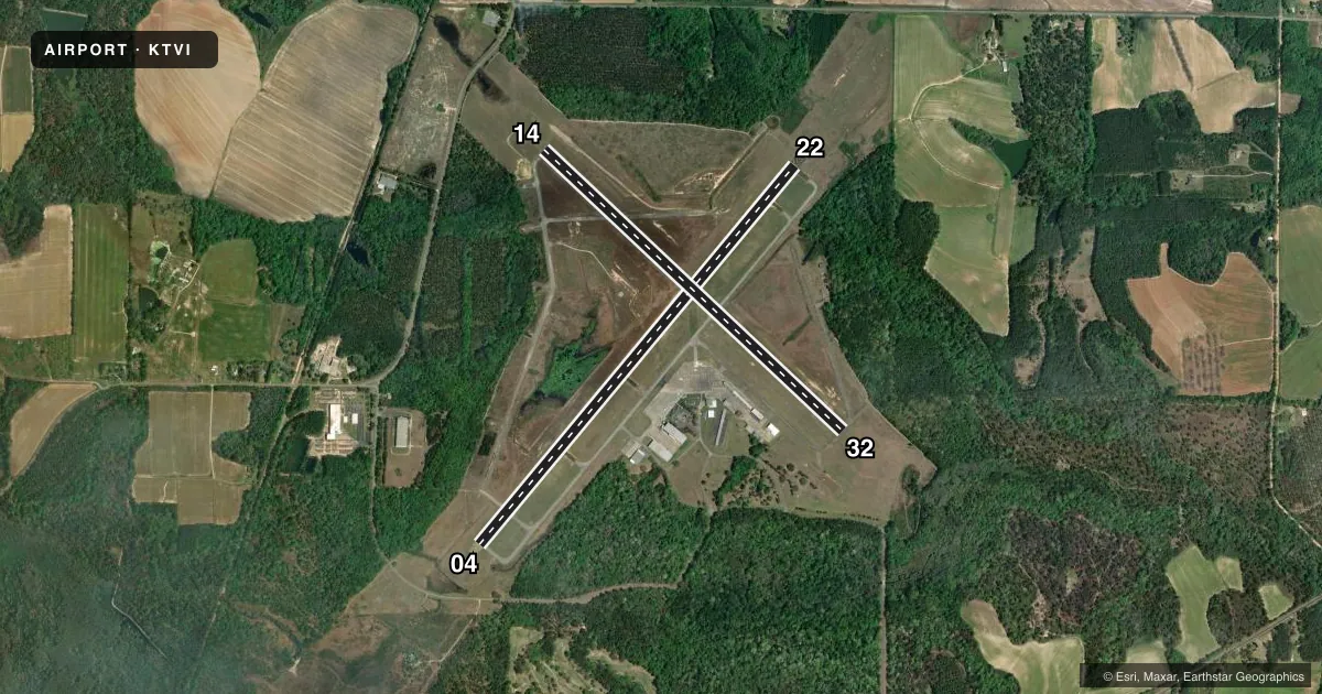
Runways & pattern
Full pagePattern entry · RWY 32
LEFT TRAFFIC| Runway | Heading (°M) | Length | Surface | Traffic |
|---|---|---|---|---|
| 04/22 | 35° / 215° | 6,004 ft | ASPH | Standard L |
| 14/32Favored | 128° / 308° | 4,999 ft | ASPH | Standard L |
Runway end performance
| End | TORA | TODA | ASDA | LDA | VGSI | Approach lights | Obstruction |
|---|---|---|---|---|---|---|---|
| 04 | 6,004' | 6,004' | 6,004' | 5,498' | PAPI 2-box left(3°) | — | 92', trees, 780' from thr, 572' R of cntrln, slope 6 |
| 22 | 6,004' | 6,004' | 5,504' | 5,504' | PAPI 2-box left(3°) | MALSF | 114', trees, 2366' from thr, 778' R of cntrln, slope 19 |
| 32 | — | — | — | — | PAPI 4-box left(3°) | — | — |
Declared distances in feet. TORA = takeoff run available, TODA = takeoff distance, ASDA = accelerate-stop, LDA = landing distance.
Airport sketch
Runways drawn to scale from FAA survey coordinates, rendered over satellite imagery. Not for navigation.
Approaches & charts
Services on the field
Fuel grades, oxygen, maintenance, ramp storage and lighting — as declared to the FAA by the airport operator.
Fuel & services
- Fuel
- 100LLAA+
- Oxygen (bottled)
- Not available
- Oxygen (bulk)
- Not available
- Airframe repair
- Major
- Power plant repair
- Major
- Other services
- INSTR,RNTL
Ramp & ground
- Transient storage
- Tie-down
- Hangar
- Landing fee
- No fee published
- Customs
- Not available
- Lighting schedule
- SEE RMK
- Beacon schedule
- SS-SR
- Beacon
- White / Green (civil land)(WG)
- Wind indicator
- Lighted
- Segmented circle
- No
Fuel & FBOs
Cheapest 100LL and Jet A on the field and nearby. Always confirm with the FBO before taxi.
Airport notes
Surface conditions, obstructions, local procedures, lighting outages and other notes published with each FAA cycle.
General notes
- TWYS ON APRON SIDE OF RWYS LGTD.
Lighting notes
- HIRL RWY 04/22 PRESET LOW INTST; TO INCR INTST & ACTVT MALSF - CTAF. ACTVT PAPI RWY 04 & 22, 32 DURG DALGT HRS - CTAF. AFTER DUSK PAPI RWY 04 & 22, 32 OPR CONSLY.
Approach & departure obstructions
- 04OBST CLNC SLOPE 20:1 TO DTHR.
Other notes
- EXISTED PRIOR TO 1959.
VFR map & nearby airports
VFR sectional. Tap any ICAO chip to open that airport.
Key facts · KTVI
Answer card- ICAO
- KTVI
- Name
- THOMASVILLE RGNL
- Location
- THOMASVILLE, GEORGIA
- Elevation
- 263.6 ft MSL
- Traffic pattern altitude
- 1,263.6 ft MSL (1,000 AGL)
- Control tower
- Non-towered (use CTAF)
- Total runways
- 2
- Longest runway
- 04/22 · 6,004 ft
- Published ILS approaches
- 0
- Published frequencies
- 5
- Magnetic variation
- 5°
- Current flight rules
- VFR
- Current wind
- 300° at 6 kt
- Favored runway now
- RWY 32
Thomasville Regional Airport is in Thomasville, Georgia. Field elevation is 263.6 ft MSL. It has two asphalt runways. The longest is runway 04/22 at 6,004 ft. There is no control tower, so expect CTAF traffic and self-announce discipline. CTAF and UNICOM are both 123.075. No ILS approaches are published, so plan with the current chart and your own weather minimums in mind.
Pattern altitude is not published. Use the standard 1,000 ft AGL pattern for light piston traffic unless local procedures or ATC say otherwise. The on-field FBO is Thomasville Regional Airport. It carries 100LL, Jet A and Jet A Prist. Call (229) 225-4313 for current service details.
A few runway notes matter here. Runway 04 has a published obstacle clearance slope to the displaced threshold. Runway 04/22 uses high intensity lights preset to low intensity. Use CTAF to raise intensity and to activate the MALSR. The PAPI on runways 04, 22 and 32 can be activated on CTAF during daylight hours. After dusk, those PAPIs operate continuously. Taxiways on the apron side of the runways are lighted. This field also sits in the Valdosta approach area. Check the current chart for the latest frequency and airspace picture before you go.