METAR & TAF KHOE
Current METAR
Observed 07:50Z
KHOE 300750Z AUTO 00000KT 10SM CLR 25/22 A3003 RMK AO2 T02480220
- Wind
- 000° @ 0 kt
- Visibility
- 10 SM
- Temp / Dew
- 25°C / 22°C
- Altimeter
- 30.03 inHg
- Clouds
- CLR
- Density alt
- 1,295 ft
- Ceiling
- Unlimited
- Rules
- VFR
Airport info & contacts
Manager on record, flight service, ARTCC, attendance schedule and pattern altitude — published by the FAA and refreshed every 28 days.
Location
- From city
- 2 NM NW
- VFR sectional
- JACKSONVILLE
- ARTCC
- ZJX · JACKSONVILLE
- NOTAM facility
- MCN (NOTAM-D)
Airport manager
- Name
- SAMANTHA RITTENHOUSE
- Phone
- 912-487-2375
- Address
- PO BOX 535, HOMERVILLE GA 31634
Flight service · Hours
- FSS MCN
- MACON1-800-WX-BRIEF
- Attendance
- Unattended
Frequencies
Tap any row to copy the frequency to your clipboard.
Runways & pattern
Full pagePattern entry · RWY 14
LEFT TRAFFICRunway end performance
| End | TORA | TODA | ASDA | LDA | VGSI | Approach lights | Obstruction |
|---|---|---|---|---|---|---|---|
| 14 | — | — | — | — | PAPI 2-box left(3°) | — | 30', trees, 320' from thr, 267' R of cntrln, slope 4 |
| 32 | — | — | — | — | PAPI 2-box left(3°) | — | 43', trees, 458' from thr, 278' R of cntrln, slope 6 |
Declared distances in feet. TORA = takeoff run available, TODA = takeoff distance, ASDA = accelerate-stop, LDA = landing distance.
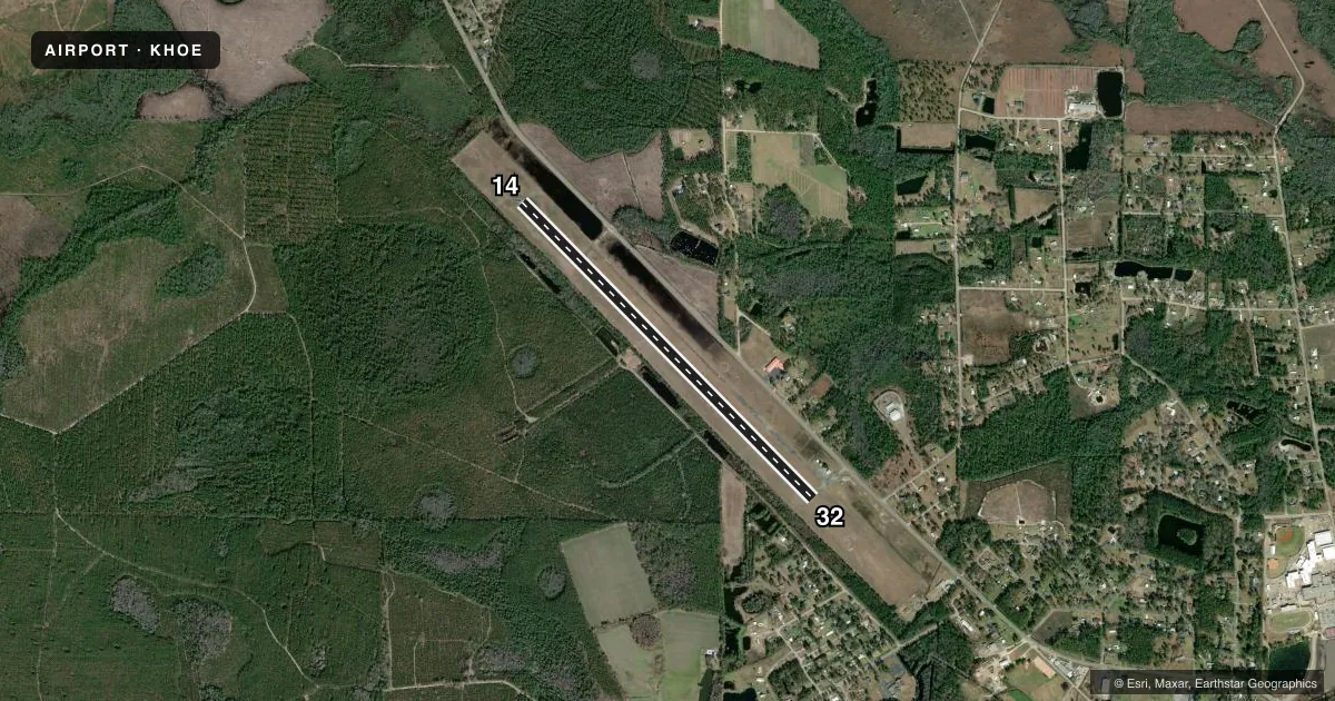
Airport sketch
Runways drawn to scale from FAA survey coordinates, rendered over satellite imagery. Not for navigation.
Approaches & charts
Services on the field
Fuel grades, oxygen, maintenance, ramp storage and lighting — as declared to the FAA by the airport operator.
Fuel & services
- Fuel
- Not available
- Oxygen (bottled)
- Not available
- Oxygen (bulk)
- Not available
- Airframe repair
- Not available
- Power plant repair
- Not available
- Other services
- AGRI
Ramp & ground
- Transient storage
- Tie-down
- Landing fee
- No fee published
- Customs
- Not available
- Lighting schedule
- SEE RMK
- Beacon schedule
- SS-SR
- Beacon
- White / Green (civil land)(WG)
- Wind indicator
- Lighted
- Segmented circle
- Yes
Fuel & FBOs
Cheapest 100LL and Jet A on the field and nearby. Always confirm with the FBO before taxi.
Airport notes
Surface conditions, obstructions, local procedures, lighting outages and other notes published with each FAA cycle.
General notes
- FOR CD CTC VALDOSTA APCH AT 229-257-2207, WHEN APCH CLSD CTC JACKSONVILLE ARTCC AT 904-845-1592.
Lighting notes
- ACTVT PAPI RY 14/32 & MIRL RY 14/32 - CTAF.
Runway surface & condition
- 14/3275 FT WIDE ASPH OVERLAY; REMAINING 37 1/2 FT WIDTH ON EACH SIDE IS OLD ASPH WITH LOOSE GRAVEL.
VFR map & nearby airports
VFR sectional. Tap any ICAO chip to open that airport.
Key facts · KHOE
Answer card- ICAO
- KHOE
- Name
- HOMERVILLE
- Location
- HOMERVILLE, GEORGIA
- Elevation
- 186.7 ft MSL
- Traffic pattern altitude
- 1,186.7 ft MSL (1,000 AGL)
- Control tower
- Non-towered (use CTAF)
- Total runways
- 1
- Longest runway
- 14/32 · 4,999 ft
- Published ILS approaches
- 0
- Published frequencies
- 4
- Magnetic variation
- 6°
- Current flight rules
- VFR
- Current wind
- 000° at 0 kt
- Favored runway now
- –
Homerville Airport (KHOE) sits in Homerville, Georgia. Field elevation is 186.7 ft MSL. The airport has one runway. Runway 14/32 is 4,999 ft asphalt, which is the longest runway on the field. No control tower is published here. Pattern altitude is not published, so plan on the standard 1,000 ft AGL for light piston traffic unless the current Chart Supplement says otherwise.
No ILS approaches are published at KHOE. The published frequencies include CTAF 122.9. Valdosta Approach handles clearance delivery and approach services when available. If approach is closed, the published remark says to contact Jacksonville ARTCC. That is worth checking before a cross-country leg.
One runway note matters here. Runway 14/32 has a 75-foot-wide asphalt overlay. The remaining width on each side is old asphalt with loose gravel. That is useful to know for rollout, braking and prop clearance on the edges. The PAPI on 14 and the medium intensity runway lights on 14/32 are activated by CTAF. There are no on-field FBOs listed. Verify fuel and services with the airport operator or by phone before arrival.