METAR & TAF KDQH
Current METAR
Observed 08:55Z
KDQH 270855Z AUTO 00000KT 10SM SCT021 SCT055 OVC070 26/24 A2990 RMK AO2 T02630237
- Wind
- 000° @ 0 kt
- Visibility
- 10 SM
- Temp / Dew
- 26°C / 24°C
- Altimeter
- 29.90 inHg
- Clouds
- OVC
- Density alt
- 1,663 ft
- Ceiling
- 7,000 ft AGL
- Rules
- VFR
Airport info & contacts
Manager on record, flight service, ARTCC, attendance schedule and pattern altitude — published by the FAA and refreshed every 28 days.
Location
- From city
- 2 NM S
- VFR sectional
- JACKSONVILLE
- ARTCC
- ZJX · JACKSONVILLE
- NOTAM facility
- MCN (NOTAM-D)
Airport manager
- Name
- CHRIS DAVIS
- Phone
- 912-384-1409
- Address
- CITY OF DOUGLAS PO BOX 470, DOUGLAS GA 31534
Flight service · Hours
- FSS MCN
- MACON1-800-WX-BRIEF
- Attendance
- M-F · 0800-1700
Frequencies
Tap any row to copy the frequency to your clipboard.
Runways & pattern
Full pagePattern entry · RWY 04
LEFT TRAFFICRunway end performance
| End | TORA | TODA | ASDA | LDA | VGSI | Approach lights | Obstruction |
|---|---|---|---|---|---|---|---|
| 04 | — | — | — | — | PAPI 2-box left(3°) | MALSR | 55', trees, 2728' from thr, 877' R of cntrln, slope 45 |
| 22 | — | — | — | — | PAPI 2-box left(2.5°) | — | 43', pole, 1301' from thr, 414' R of cntrln, slope 25 |
Declared distances in feet. TORA = takeoff run available, TODA = takeoff distance, ASDA = accelerate-stop, LDA = landing distance.
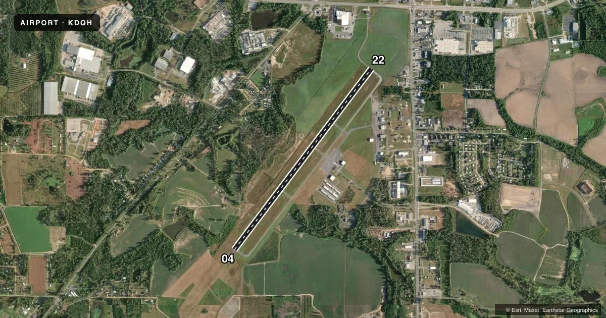
Airport sketch
Runways drawn to scale from FAA survey coordinates, rendered over satellite imagery. Not for navigation.
Approaches & charts
ILS · 1
Services on the field
Fuel grades, oxygen, maintenance, ramp storage and lighting — as declared to the FAA by the airport operator.
Fuel & services
- Fuel
- 100LLA+
- Oxygen (bottled)
- Not available
- Oxygen (bulk)
- Not available
- Airframe repair
- Minor
- Power plant repair
- Minor
- Other services
- AGRI,AMB,INSTR
Ramp & ground
- Transient storage
- Tie-down
- Landing fee
- No fee published
- Customs
- Not available
- Lighting schedule
- SEE RMK
- Beacon schedule
- SS-SR
- Beacon
- White / Green (civil land)(WG)
- Wind indicator
- Lighted
- Segmented circle
- Yes
Fuel & FBOs
Cheapest 100LL and Jet A on the field and nearby. Always confirm with the FBO before taxi.
Airport notes
Surface conditions, obstructions, local procedures, lighting outages and other notes published with each FAA cycle.
General notes
- FOR CD CTC JACKSONVILLE ARTCC AT 904-845-1592.
- WILDLIFE ACT IN VCY OF APT
Lighting notes
- ACTVT MALSR RWY 04; PAPI RWY 04 & 22; MIRL RWY 04/22 - CTAF.
Other notes
- EXISTED PRIOR TO 1959.
VFR map & nearby airports
VFR sectional. Tap any ICAO chip to open that airport.
Key facts · KDQH
Answer card- ICAO
- KDQH
- Name
- DOUGLAS MUNI
- Location
- DOUGLAS, GEORGIA
- Elevation
- 256.5 ft MSL
- Traffic pattern altitude
- 1,256.5 ft MSL (1,000 AGL)
- Control tower
- Non-towered (use CTAF)
- Total runways
- 1
- Longest runway
- 04/22 · 6,000 ft
- Published ILS approaches
- 1
- Published frequencies
- 2
- Magnetic variation
- 6°
- Current flight rules
- VFR
- Current wind
- 000° at 0 kt
- Favored runway now
- –
Douglas Muni (KDQH) sits in Douglas, Georgia. Field elevation is 256.5 ft MSL. The airport has one runway. Runway 04/22 is 6,000 ft long with asphalt pavement. There is no control tower, so use CTAF 122.8 for self-announce traffic. The published pattern altitude is not listed in the facts. Use the standard 1,000 ft AGL for light piston traffic unless the current Chart Supplement says otherwise. The field has one ILS approach to runway 04. The published remarks also note medium intensity approach lighting with runway alignment indicator lights on runway 04. PAPI is available on both runway ends. Medium intensity runway lights are on 04 and 22.
Douglas Municipal Airport is on the field. It carries AVGAS 100LL and Jet A. Call the airport directly at (912) 384-1409 for current service details before you go. Wildlife activity is reported in the vicinity. Keep your scan active on taxi, takeoff and landing. For clearance delivery, contact Jacksonville ARTCC at 904-845-1592. This is a non-towered field. Plan your arrival, make your position calls early and watch for local traffic using the common traffic advisory frequency.