METAR & TAF 16J
Current METAR
Observed 17:15Z
K16J 261715Z AUTO 27006KT 10SM -RA FEW050 26/26 A3003 RMK AO2
- Wind
- 270° @ 6 kt
- Visibility
- 10 SM
- Temp / Dew
- 26°C / 26°C
- Altimeter
- 30.03 inHg
- Clouds
- FEW
- Density alt
- 1,596 ft
- Ceiling
- Unlimited
- Rules
- VFR
Airport info & contacts
Manager on record, flight service, ARTCC, attendance schedule and pattern altitude — published by the FAA and refreshed every 28 days.
Location
- From city
- 2 NM SE
- VFR sectional
- JACKSONVILLE
- ARTCC
- ZJX · JACKSONVILLE
- NOTAM facility
- MCN (NOTAM-D)
Airport manager
- Name
- LUTHER HERNDON
- Phone
- 229-995-3787
- Address
- 2678 ALBANY HWY, DAWSON GA 39842
Flight service · Hours
- FSS MCN
- MACON1-800-WX-BRIEF
- Attendance
- MON-FRI · 1000-1600
Frequencies
Tap any row to copy the frequency to your clipboard.
Runways & pattern
Full pagePattern entry · RWY 32
LEFT TRAFFICRunway end performance
| End | TORA | TODA | ASDA | LDA | VGSI | Approach lights | Obstruction |
|---|---|---|---|---|---|---|---|
| 14 | — | — | — | — | PAPI 2-box left(3°) | — | 22', trees, 574' from thr, 242' R of cntrln, slope 17 |
| 32 | — | — | — | — | PAPI 2-box left(3°) | — | 31', trees, 510' from thr, 231' R of cntrln, slope 10 |
Declared distances in feet. TORA = takeoff run available, TODA = takeoff distance, ASDA = accelerate-stop, LDA = landing distance.
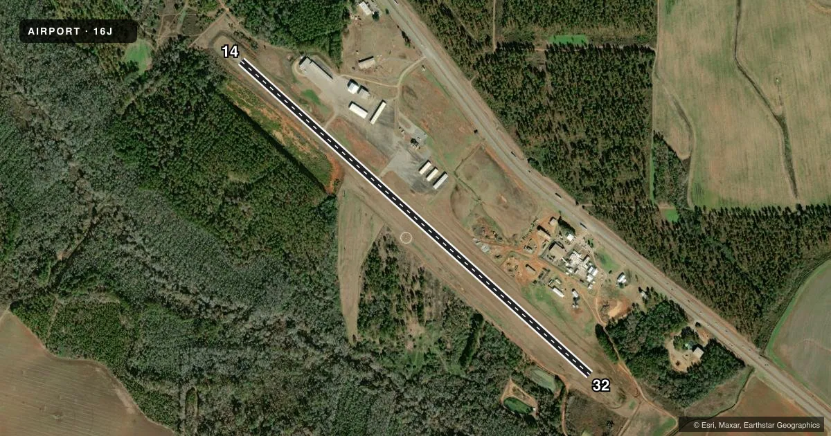
Airport sketch
Runways drawn to scale from FAA survey coordinates, rendered over satellite imagery. Not for navigation.
Approaches & charts
Services on the field
Fuel grades, oxygen, maintenance, ramp storage and lighting — as declared to the FAA by the airport operator.
Fuel & services
- Fuel
- 100LLA+
- Oxygen (bottled)
- Not available
- Oxygen (bulk)
- Not available
- Airframe repair
- Not available
- Power plant repair
- Not available
- Other services
- AGRI
Ramp & ground
- Transient storage
- Tie-down
- Landing fee
- No fee published
- Customs
- Not available
- Lighting schedule
- SEE RMK
- Beacon schedule
- SS-SR
- Beacon
- White / Green (civil land)(WG)
- Wind indicator
- Lighted
- Segmented circle
- Yes
Fuel & FBOs
Cheapest 100LL and Jet A on the field and nearby. Always confirm with the FBO before taxi.
Airport notes
Surface conditions, obstructions, local procedures, lighting outages and other notes published with each FAA cycle.
General notes
- DEER ON & INVOF ARPT.
- FOR CD CTC JACKSONVILLE ARTCC AT 904-845-1592.
- BIRDS INVOF ARPT
Lighting notes
- PAPI RWY 14 & 32 OPER CONSLY. MIRL RWY 14/32 PRESET MED INTST DUSK-2200, AFT 2200 ACTVT - CTAF.
Other notes
- VFR OPNS ONLY
VFR map & nearby airports
VFR sectional. Tap any ICAO chip to open that airport.
Key facts · 16J
Answer card- ICAO
- 16J
- Name
- DAWSON MUNI
- Location
- DAWSON, GEORGIA
- Elevation
- 332.2 ft MSL
- Traffic pattern altitude
- 1,332.2 ft MSL (1,000 AGL)
- Control tower
- Non-towered (use CTAF)
- Total runways
- 1
- Longest runway
- 14/32 · 4,507 ft
- Published ILS approaches
- 0
- Published frequencies
- 2
- Magnetic variation
- 2°
- Current flight rules
- VFR
- Current wind
- 270° at 6 kt
- Favored runway now
- RWY 32
Dawson Muni sits in Dawson, Georgia. The field elevation is 332.2 ft MSL. It has one runway. Runway 14/32 is 4,507 ft long with asphalt pavement. There is no control tower. CTAF and UNICOM are both 123.05. The runway lights for 14 and 32 are preset from dusk to 2200. After 2200, you activate them by CTAF. PAPI for both ends runs continuously.
No ILS approaches are published here. This is a VFR-only field. Pattern altitude is not published in the facts, so use the standard 1,000 ft AGL unless the current Chart Supplement says otherwise. Dawson Municipal Airport is the on-field FBO. It carries AVGAS 100LL and Jet A. Call (229) 995-3787 before you go if you need current service details.
For a first-time arrival, watch for birds in the area and deer on or near the airport. Clearance delivery is handled through Jacksonville ARTCC at 904-845-1592. The runway is long enough for a range of light aircraft. The lack of published ILS means you should plan for VFR conditions and keep an eye on the lighting setup if you expect a late arrival.