METAR & TAF 82A
82A does not publish a METAR.
Showing the nearest reporting station: KACJ (JIMMY CARTER RGNL) · 19.0 NM away. Conditions at 82A may differ.
METAR · KACJ
Observed 05:55Z
KACJ 270555Z AUTO 28007KT 10SM CLR 27/27 A2991 RMK AO2 60000 T02690269 10305 20269 50001 $
- Wind
- 280° @ 7 kt
- Visibility
- 10 SM
- Temp / Dew
- 27°C / 27°C
- Altimeter
- 29.91 inHg
- Clouds
- CLR
- Density alt
- 2,298 ft
- Ceiling
- Unlimited
- Rules
- VFR
Airport info & contacts
Manager on record, flight service, ARTCC, attendance schedule and pattern altitude — published by the FAA and refreshed every 28 days.
Location
- From city
- 3 NM SE
- VFR sectional
- ATLANTA
- ARTCC
- ZTL · ATLANTA
- NOTAM facility
- MCN (NOTAM-D)
Airport manager
- Name
- FRANK BAIR
- Phone
- 937-308-6940
- Address
- 100 EAST BURKHALTER AVE, PO BOX 481, BUENA VISTA GA 31803
Flight service · Hours
- FSS MCN
- MACON1-800-WX-BRIEF
- Attendance
- Unattended
Frequencies
Tap any row to copy the frequency to your clipboard.
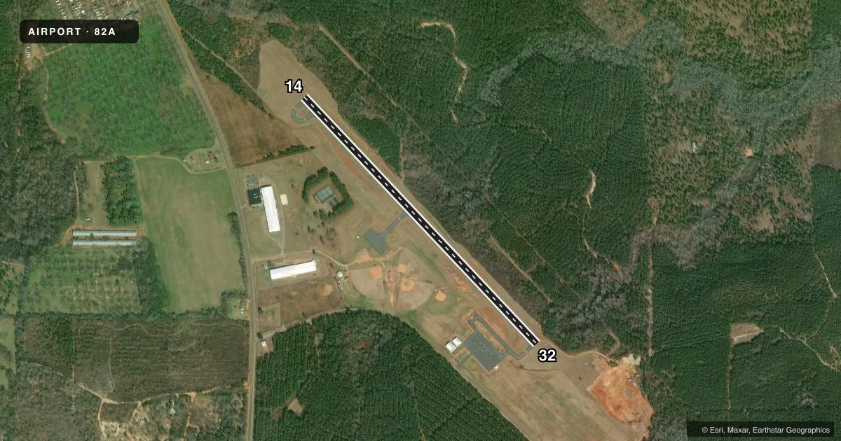
Runways & pattern
Full pagePattern entry · RWY 32
LEFT TRAFFICRunway end performance
| End | TORA | TODA | ASDA | LDA | VGSI | Approach lights | Obstruction |
|---|---|---|---|---|---|---|---|
| 14 | — | — | — | — | — | — | 61', trees, 1043' from thr, 194' R of cntrln, slope 13 |
| 32 | — | — | — | — | — | — | 73', trees, 1453' from thr, 234' R of cntrln, slope 17 |
Declared distances in feet. TORA = takeoff run available, TODA = takeoff distance, ASDA = accelerate-stop, LDA = landing distance.
Airport sketch
Runways drawn to scale from FAA survey coordinates, rendered over satellite imagery. Not for navigation.
Approaches & charts
Services on the field
Fuel grades, oxygen, maintenance, ramp storage and lighting — as declared to the FAA by the airport operator.
Fuel & services
- Fuel
- 100LL
- Oxygen (bottled)
- Not available
- Oxygen (bulk)
- Not available
- Airframe repair
- Not available
- Power plant repair
- Not available
Ramp & ground
- Transient storage
- Tie-down
- Landing fee
- No fee published
- Customs
- Not available
- Lighting schedule
- SEE RMK
- Beacon schedule
- SS-SR
- Beacon
- White / Green (civil land)(WG)
- Wind indicator
- Yes
- Segmented circle
- Yes
Fuel & FBOs
Cheapest 100LL and Jet A on the field and nearby. Always confirm with the FBO before taxi.
Airport notes
Surface conditions, obstructions, local procedures, lighting outages and other notes published with each FAA cycle.
General notes
- PAEW ON & INVOF RWY.
- FOR CD CTC ATLANTA APCH AT 678-364-6132, WHEN APCH CLSD CTC ATLANTA ARTCC AT 770-210-7692.
Lighting notes
- ACTVT MIRL RWY 14/32 -CTAF.
Other notes
- VFR OPNS ONLY.
VFR map & nearby airports
VFR sectional. Tap any ICAO chip to open that airport.
Key facts · 82A
Answer card- ICAO
- 82A
- Name
- MARION COUNTY
- Location
- BUENA VISTA, GEORGIA
- Elevation
- 682 ft MSL
- Traffic pattern altitude
- 1,682 ft MSL (1,000 AGL)
- Control tower
- Non-towered (use CTAF)
- Total runways
- 1
- Longest runway
- 14/32 · 3,200 ft
- Published ILS approaches
- 0
- Published frequencies
- 1
- Magnetic variation
- 2°
- Current flight rules
- VFR
- Current wind
- 280° at 7 kt
- Favored runway now
- RWY 32
Marion County Airport (82A) sits in Buena Vista, Georgia. Field elevation is 682 ft MSL. The airport has one runway. Runway 14/32 is 3,200 ft long with an asphalt surface. The field is not towered. CTAF is 122.9.
No ILS approaches are published here. Published remarks say this is VFR only. The runway lights on 14/32 are medium intensity. They are activated through the common traffic advisory frequency. A precision approach path indicator is east of the runway and in the vicinity of the field.
Pattern altitude is not published. Use the standard 1,000 ft AGL pattern for light piston traffic unless the current Chart Supplement says otherwise. There are no on-field FBOs listed in the facts, so verify fuel and services with the airport operator or the FBO directly before arrival. For clearance delivery, contact Atlanta Approach at 678-364-6132. When Atlanta Approach is closed, contact Atlanta Air Route Traffic Control Center at 770-210-7692. If you are planning a night arrival or a first trip in, confirm lighting use and any local procedures before you go.