METAR & TAF KPIM
Current METAR
Observed 05:55Z
KPIM 270555Z AUTO 9SM CLR 26/26 A2997 RMK AO2 10302 20253
- Wind
- Calm
- Visibility
- 9 SM
- Temp / Dew
- 26°C / 26°C
- Altimeter
- 29.97 inHg
- Clouds
- CLR
- Density alt
- 2,376 ft
- Ceiling
- Unlimited
- Rules
- VFR
Airport info & contacts
Manager on record, flight service, ARTCC, attendance schedule and pattern altitude — published by the FAA and refreshed every 28 days.
Location
- From city
- 2 NM SW
- VFR sectional
- ATLANTA
- ARTCC
- ZTL · ATLANTA
- NOTAM facility
- MCN (NOTAM-D)
Airport manager
- Name
- RONALD PENDERGRASS
- Phone
- 706-663-2083
- Address
- 789 SKY MEADOW DRIVE, PINE MOUNTAIN GA 31822
Flight service · Hours
- FSS MCN
- MACON1-800-WX-BRIEF
- Attendance
- 0900-1700
Frequencies
Tap any row to copy the frequency to your clipboard.
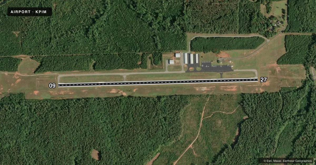
Runways & pattern
Full pagePattern entry · RWY 09
LEFT TRAFFICRunway end performance
| End | TORA | TODA | ASDA | LDA | VGSI | Approach lights | Obstruction |
|---|---|---|---|---|---|---|---|
| 09 | — | — | — | — | PAPI 4-box left(3°) | — | 40', trees, 1080' from thr, 366' R of cntrln, slope 22 |
| 27 | — | — | — | — | PAPI 4-box left(3°) | — | 85', trees, 1305' from thr, 396' R of cntrln, slope 13 |
Declared distances in feet. TORA = takeoff run available, TODA = takeoff distance, ASDA = accelerate-stop, LDA = landing distance.
Airport sketch
Runways drawn to scale from FAA survey coordinates, rendered over satellite imagery. Not for navigation.
Approaches & charts
Services on the field
Fuel grades, oxygen, maintenance, ramp storage and lighting — as declared to the FAA by the airport operator.
Fuel & services
- Fuel
- 100LLA+
- Oxygen (bottled)
- Not available
- Oxygen (bulk)
- Not available
- Airframe repair
- Major
- Power plant repair
- Major
Ramp & ground
- Transient storage
- Tie-down
- Hangar
- Landing fee
- No fee published
- Customs
- Not available
- Lighting schedule
- SEE RMK
- Beacon schedule
- SS-SR
- Beacon
- White / Green (civil land)(WG)
- Wind indicator
- Lighted
- Segmented circle
- Yes
Fuel & FBOs
Cheapest 100LL and Jet A on the field and nearby. Always confirm with the FBO before taxi.
Airport notes
Surface conditions, obstructions, local procedures, lighting outages and other notes published with each FAA cycle.
General notes
- GCO AVBL ON FREQ 121.725 THRU MCN CLEARANCE DELIVERY.
Lighting notes
- ACTVT MIRL RWY 09/27 - CTAF. PAPI RWY 09 & 27 OPR CONSLY.
Fuel notes
- 100LLFUEL 24 HR CREDIT CARD SVC AVBL.
Other notes
- MANAGERAFT HRS CALL 770-880-0765.
VFR map & nearby airports
VFR sectional. Tap any ICAO chip to open that airport.
Key facts · KPIM
Answer card- ICAO
- KPIM
- Name
- HARRIS COUNTY
- Location
- PINE MOUNTAIN, GEORGIA
- Elevation
- 902 ft MSL
- Traffic pattern altitude
- 1,902 ft MSL (1,000 AGL)
- Control tower
- Non-towered (use CTAF)
- Total runways
- 1
- Longest runway
- 09/27 · 5,002 ft
- Published ILS approaches
- 0
- Published frequencies
- 7
- Magnetic variation
- 3°
- Current flight rules
- VFR
- Current wind
- Calm / unavailable
- Favored runway now
- –
Harris County Airport sits in Pine Mountain, Georgia. The field elevation is 902 ft MSL. It has one runway. Runway 09/27 is 5,002 ft long with asphalt pavement. There is no control tower. The airport uses CTAF and UNICOM on 122.8. Approach and departure services are handled by Atlanta frequencies listed in the Chart Supplement. No ILS approaches are published here.
For pattern work, the published pattern altitude is not given. Use the standard 1,000 ft AGL for light piston operations unless the current Chart Supplement says otherwise. The airport sits in west-central Georgia near the Alabama line. That makes it a straightforward stop for local VFR traffic. Still, check the sectional for the current airspace picture before you go.
Harris County Airport has one on-field FBO. Harris County Airport carries 100LL and Jet A. Fuel is available with 24-hour credit card service. After hours, the published manager number is the one to use. The field also has a ground communication outlet on 121.725 through Macon clearance delivery. Runway 09/27 has medium intensity lights that are activated by CTAF. The PAPI on both ends operates continuously. That helps for night arrivals and stabilized approaches.