METAR & TAF KCCO
Current METAR
Observed 08:55Z
KCCO 270855Z AUTO 00000KT 5SM BR CLR 24/24 A2994 RMK AO2 T02430238
- Wind
- 000° @ 0 kt
- Visibility
- 5 SM
- Temp / Dew
- 24°C / 24°C
- Altimeter
- 29.94 inHg
- Clouds
- CLR
- Density alt
- 2,258 ft
- Ceiling
- Unlimited
- Rules
- MVFR
Airport info & contacts
Manager on record, flight service, ARTCC, attendance schedule and pattern altitude — published by the FAA and refreshed every 28 days.
Location
- From city
- 4 NM S
- VFR sectional
- ATLANTA
- ARTCC
- ZTL · ATLANTA
- NOTAM facility
- MCN (NOTAM-D)
Airport manager
- Name
- CALVIN WALKER
- Phone
- 770-254-8102
- Address
- 115 AIRPORT ROAD, BOX 2, NEWNAN GA 30263
Flight service · Hours
- FSS MCN
- MACON1-800-WX-BRIEF
- Attendance
- M-F · 0700-2000
- S-S · 0800-1800
Frequencies
Tap any row to copy the frequency to your clipboard.
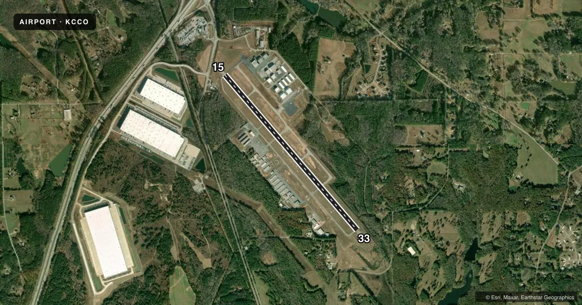
Runways & pattern
Full pagePattern entry · RWY 15
LEFT TRAFFICRunway end performance
| End | TORA | TODA | ASDA | LDA | VGSI | Approach lights | Obstruction |
|---|---|---|---|---|---|---|---|
| 15 | — | — | — | — | PAPI 4-box left(3°) | — | 64', trees, 927' from thr, 582' R of cntrln, slope 11 |
| 33 | — | — | — | — | PAPI 4-box left(3°) | MALSF | 30', trees, 201' from thr, 345' R of cntrln, slope 0 |
Declared distances in feet. TORA = takeoff run available, TODA = takeoff distance, ASDA = accelerate-stop, LDA = landing distance.
Airport sketch
Runways drawn to scale from FAA survey coordinates, rendered over satellite imagery. Not for navigation.
Approaches & charts
ILS · 1
Services on the field
Fuel grades, oxygen, maintenance, ramp storage and lighting — as declared to the FAA by the airport operator.
Fuel & services
- Fuel
- 100LLA+
- Oxygen (bottled)
- Low pressure
- Oxygen (bulk)
- Not available
- Airframe repair
- Major
- Power plant repair
- Major
- Other services
- AMB,AVNCS,INSTR,RNTL
Ramp & ground
- Transient storage
- Tie-down
- Landing fee
- No fee published
- Customs
- Not available
- Lighting schedule
- SEE RMK
- Beacon schedule
- SS-SR
- Beacon
- White / Green (civil land)(WG)
- Wind indicator
- Lighted
- Segmented circle
- Yes
Fuel & FBOs
Cheapest 100LL and Jet A on the field and nearby. Always confirm with the FBO before taxi.
Airport notes
Surface conditions, obstructions, local procedures, lighting outages and other notes published with each FAA cycle.
General notes
- GCO AVBL ON FREQ 121.725 THRU FLT SVCS.
- WILDLIFE INVOF ARPT.
- EXTENSIVE FLIGHT TRAINING ON AND INVOF AIRPORT
- FOR CD CTC ATLANTA APCH AT 678-364-6131.
Lighting notes
- ACTVT MALSF RWY 33; HIRL RWY 15/33 - CTAF.
Approach & departure obstructions
- 1515 FT POWER POLES, 139 FT FROM EOR, 355 FT RIGHT OF CNTRLN.
- 3330 FT TREES, 264 FT RIGHT OF CNTRLN AT RWY END OUT TO 200 FT FM RWY END.
VFR map & nearby airports
VFR sectional. Tap any ICAO chip to open that airport.
Key facts · KCCO
Answer card- ICAO
- KCCO
- Name
- NEWNAN COWETA COUNTY
- Location
- ATLANTA, GEORGIA
- Elevation
- 970.2 ft MSL
- Traffic pattern altitude
- 1,970.2 ft MSL (1,000 AGL)
- Control tower
- Non-towered (use CTAF)
- Total runways
- 1
- Longest runway
- 15/33 · 5,500 ft
- Published ILS approaches
- 1
- Published frequencies
- 4
- Magnetic variation
- 3°
- Current flight rules
- MVFR
- Current wind
- 000° at 0 kt
- Favored runway now
- –
Newnan Coweta County Airport sits in Atlanta, Georgia, near Newnan. Field elevation is 970.2 ft MSL. The airport has one runway. Runway 15/33 is 5,500 ft long and asphalt. There is no control tower. Pattern altitude is not published, so use the standard 1,000 ft AGL for light piston operations unless the current Chart Supplement says otherwise.
The field has one ILS approach to runway 33. Runway 33 also has MALSR lighting. High intensity runway lights are on both runway ends. Use CTAF for lighting activation. Wildlife is reported in the airport area. Extensive flight training also takes place on and near the field. Expect busy local traffic. The published remarks also note trees near the runway 33 end and power poles near the runway 15 end. That makes a careful stabilized approach and a good scan on departure worth the extra attention.
CCO Airport Services is on the field. It carries 100LL, Jet A and Jet A Prist. For clearance delivery, Atlanta Approach is listed at 678-364-6131. Ground control is available through flight services on 121.725. If you need current noise or operating restrictions, check the current FAA Chart Supplement before you go.