METAR & TAF KCTJ
Current METAR
Observed 05:15Z
KCTJ 270515Z AUTO 00000KT 7SM CLR 24/23 A3002 RMK AO2 T02390232
- Wind
- 000° @ 0 kt
- Visibility
- 7 SM
- Temp / Dew
- 24°C / 23°C
- Altimeter
- 30.02 inHg
- Clouds
- CLR
- Density alt
- 2,400 ft
- Ceiling
- Unlimited
- Rules
- VFR
Airport info & contacts
Manager on record, flight service, ARTCC, attendance schedule and pattern altitude — published by the FAA and refreshed every 28 days.
Location
- From city
- 5 NM NW
- VFR sectional
- ATLANTA
- ARTCC
- ZTL · ATLANTA
- NOTAM facility
- MCN (NOTAM-D)
Airport manager
- Name
- MARK WEINSTEIN
- Phone
- 470-431-0024
- Address
- 635 REGIONAL AIRPORT ROAD, CARROLLTON GA 30117
Flight service · Hours
- FSS MCN
- MACON1-800-WX-BRIEF
- Attendance
- 0800-1800
Frequencies
Tap any row to copy the frequency to your clipboard.
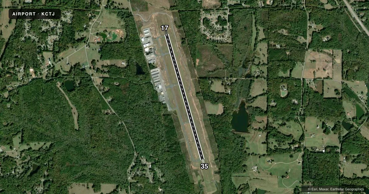
Runways & pattern
Full pagePattern entry · RWY 17
LEFT TRAFFICRunway end performance
| End | TORA | TODA | ASDA | LDA | VGSI | Approach lights | Obstruction |
|---|---|---|---|---|---|---|---|
| 17 | — | — | — | — | PAPI 4-box left(3°) | — | 92', trees, 2341' from thr, 401' R of cntrln, slope 23 |
| 35 | — | — | — | — | PAPI 4-box left(3°) | — | 34', trees, 948' from thr, 575' R of cntrln, slope 22 |
Declared distances in feet. TORA = takeoff run available, TODA = takeoff distance, ASDA = accelerate-stop, LDA = landing distance.
Airport sketch
Runways drawn to scale from FAA survey coordinates, rendered over satellite imagery. Not for navigation.
Approaches & charts
ILS · 1
Services on the field
Fuel grades, oxygen, maintenance, ramp storage and lighting — as declared to the FAA by the airport operator.
Fuel & services
- Fuel
- 100LLA+
- Oxygen (bottled)
- Not available
- Oxygen (bulk)
- Not available
- Airframe repair
- Major
- Power plant repair
- Major
- Other services
- AVNCS,INSTR,RNTL
Ramp & ground
- Transient storage
- Tie-down
- Hangar
- Landing fee
- No fee published
- Customs
- Not available
- Lighting schedule
- SEE RMK
- Beacon schedule
- SS-SR
- Beacon
- White / Green (civil land)(WG)
- Wind indicator
- Lighted
- Segmented circle
- Yes
Fuel & FBOs
Cheapest 100LL and Jet A on the field and nearby. Always confirm with the FBO before taxi.
Airport notes
Surface conditions, obstructions, local procedures, lighting outages and other notes published with each FAA cycle.
General notes
- DEER AND TURKEYS ON & NEAR RWYS AT ALL TIMES.
- FOR APCH/DEP SVC CTC ATLANTA APCH AT 678-364-6131. IF RLS TIME IS EXPD TO BE LESS THAN 5 MINS, CTC CD.
Lighting notes
- HIRL RWY 17/35 PRESET LOW INTST DUSK-2200, AFT 2200 ACTVT - CTAF. PAPI RWYS 17 & 35 - CTAF.
VFR map & nearby airports
VFR sectional. Tap any ICAO chip to open that airport.
Key facts · KCTJ
Answer card- ICAO
- KCTJ
- Name
- WEST GEORGIA RGNL/O V GRAY FLD
- Location
- CARROLLTON, GEORGIA
- Elevation
- 1,164.6 ft MSL
- Traffic pattern altitude
- 2,164.6 ft MSL (1,000 AGL)
- Control tower
- Non-towered (use CTAF)
- Total runways
- 1
- Longest runway
- 17/35 · 5,503 ft
- Published ILS approaches
- 1
- Published frequencies
- 5
- Magnetic variation
- 4°
- Current flight rules
- VFR
- Current wind
- 000° at 0 kt
- Favored runway now
- –
West Georgia Rgnl/O V Gray Fld sits in Carrollton, Georgia. The field elevation is 1,164.6 ft MSL. It has one runway, 17/35, which is 5,503 ft long with asphalt pavement. There is no control tower. Pattern altitude is not published, so use the standard 1,000 ft AGL pattern unless local procedures say otherwise.
An ILS is available to runway 35. The published remarks also note that deer and turkeys are on and near the runways at all times. That is worth planning for on both taxi and takeoff. The runway lights on 17/35 are preset to medium intensity from dusk to 2200. After 2200, you activate them on CTAF. The precision approach path indicators for both runway ends operate continuously.
West Georgia Regional Airport is the on-field FBO. It carries 100LL and Jet A. For approach and departure service, Atlanta Approach handles the area. The published remarks say to contact clearance delivery if your release time is expected to be less than 5 minutes. This is a non-towered field, so keep your radio work tight and verify current procedures before arrival. The airport sits in west Georgia terrain, so density and performance planning still matter, especially on warm days.