METAR & TAF KVPC
Current METAR
Observed 18:15Z
KVPC 261815Z AUTO 28007KT 10SM 32/25 A2999 RMK AO2
- Wind
- 280° @ 7 kt
- Visibility
- 10 SM
- Temp / Dew
- 32°C / 25°C
- Altimeter
- 29.99 inHg
- Clouds
- Clear
- Density alt
- 2,894 ft
- Ceiling
- Unlimited
- Rules
- VFR
Airport info & contacts
Manager on record, flight service, ARTCC, attendance schedule and pattern altitude — published by the FAA and refreshed every 28 days.
Location
- From city
- 3 NM SW
- VFR sectional
- ATLANTA
- Pattern altitude
- 1,041 ft AGL · 1,800 ft MSL
- ARTCC
- ZTL · ATLANTA
- NOTAM facility
- VPC (NOTAM-D)
Airport manager
- Name
- FREDDY MORGAN
- Phone
- 770-387-5672
- Address
- PO BOX 1390, CARTERSVILLE GA 30120
Flight service · Hours
- FSS MCN
- MACON1-800-WX-BRIEF
- Attendance
- 0600-2000
Frequencies
Tap any row to copy the frequency to your clipboard.
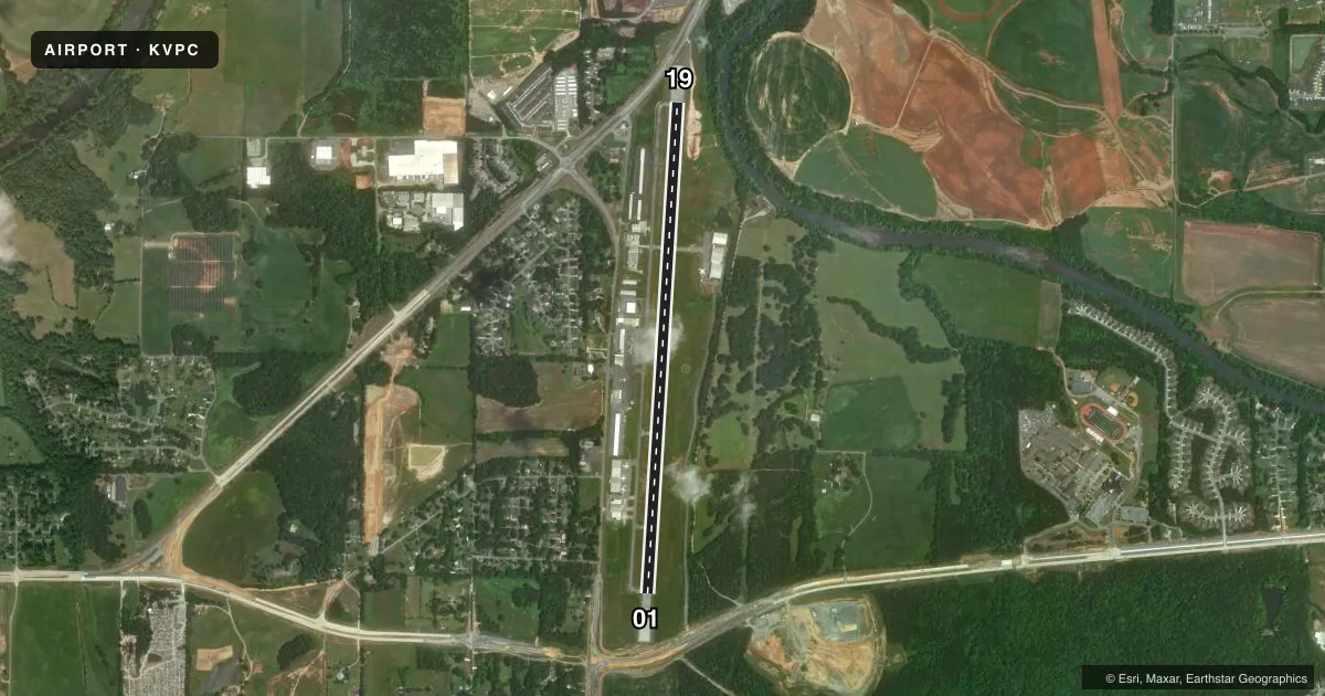
Runways & pattern
Full pagePattern entry · RWY 01
LEFT TRAFFICRunway end performance
| End | TORA | TODA | ASDA | LDA | VGSI | Approach lights | Obstruction |
|---|---|---|---|---|---|---|---|
| 01 | — | — | — | — | PAPI 2-box left(3°) | — | 93', trees, 1324' from thr, 121' R of cntrln, slope 12 |
| 19 | — | — | — | — | PAPI 2-box left(3°) | — | 41', trees, 476' from thr, 283' R of cntrln, slope 6 |
Declared distances in feet. TORA = takeoff run available, TODA = takeoff distance, ASDA = accelerate-stop, LDA = landing distance.
Airport sketch
Runways drawn to scale from FAA survey coordinates, rendered over satellite imagery. Not for navigation.
Approaches & charts
Services on the field
Fuel grades, oxygen, maintenance, ramp storage and lighting — as declared to the FAA by the airport operator.
Fuel & services
- Fuel
- 100LLA+
- Oxygen (bottled)
- Not available
- Oxygen (bulk)
- Not available
- Airframe repair
- Major
- Power plant repair
- Major
- Other services
- AFRT,CHTR,INSTR,RNTL,SALES
Ramp & ground
- Transient storage
- Tie-down
- Landing fee
- No fee published
- Customs
- Not available
- Lighting schedule
- SEE RMK
- Beacon schedule
- SS-SR
- Beacon
- White / Green (civil land)(WG)
- Wind indicator
- Lighted
- Segmented circle
- No
Fuel & FBOs
Cheapest 100LL and Jet A on the field and nearby. Always confirm with the FBO before taxi.
Airport notes
Surface conditions, obstructions, local procedures, lighting outages and other notes published with each FAA cycle.
General notes
- ULTRALIGHT/LSA ACT ON AND INVOF ARPT.
- DEER ON & INVOF ARPT.
- ULTRALIGHT/LSA TFC PAT INSIDE NORMAL PAT WITH CENTRAL THIRD OF RWY 01/19 DSGND ULTRALIGHT/LSA LNDG & TKOF AREA. ULTRALIGHT/LSA PAT ENTRY CROSSES FIELD APRXLY 2000 FT FROM EITHER APCH END AT 541 FT AGL.
- GRASS STRIP 4.9 NM NW OF ARPT.
- RWY/TWY SEPN APPROX 200 FT. SOUTH END TWY/PARKED ACFT SEPN APPROX 75 FT.
- RAMP FEES FOR TURBINE ACFT.
- FOR APCH/DEP SVC CTC ATLANTA APCH AT 678-364-6131.
- FOR CD CTC ATLANTA APCH AT 678-364-6131.
Lighting notes
- REIL RWY 19; PAPI RWY 01 & 19; HIRL RWY 01/19 OPER DUSK-2200. AFT 2200 ACTVT - CTAF.
Approach & departure obstructions
- 01APCH SLP IS 17:1 TO DSPLCD THLD, 130 FT TREES 2275 FT OUT AND 403 FT LEFT.
Other notes
- TPA FOR LGT ACFT 1041 FT AGL, TPA FOR JET & TURBOPROP ACFT 1541 FT AGL, TPA FOR ULTRALIGHT ACFT 541 FT AGL.
- MANAGERASST CITY MGR.
- MANAGERFBO PHONE NR 770-382-9800.
VFR map & nearby airports
VFR sectional. Tap any ICAO chip to open that airport.
Key facts · KVPC
Answer card- ICAO
- KVPC
- Name
- CARTERSVILLE
- Location
- CARTERSVILLE, GEORGIA
- Elevation
- 758.6 ft MSL
- Traffic pattern altitude
- 1,799.6 ft MSL (1,041 AGL)
- Control tower
- Non-towered (use CTAF)
- Total runways
- 1
- Longest runway
- 01/19 · 5,760 ft
- Published ILS approaches
- 0
- Published frequencies
- 4
- Magnetic variation
- 4°
- Current flight rules
- VFR
- Current wind
- 280° at 7 kt
- Favored runway now
- RWY 01
KVPC is in Cartersville, Georgia. The field elevation is 758.6 ft MSL. It has one runway, 01/19, which is 5,760 ft long. There is no control tower. Atlanta Approach handles clearance delivery plus approach and departure service. The published traffic pattern altitude for light aircraft is 1,799.6 ft MSL, which is 1,041 ft AGL.
No ILS approaches are published here. Phoenix Air is on the field. It carries 100LL and Jet A Prist. Call the FBO directly at (770) 387-2000 for current availability. The airport remarks also note that runway and taxiway separation is about 200 ft. The south end taxiway sits about 75 ft from parked aircraft. Ultralight and light sport traffic is active here. Their pattern is inside the normal pattern. They use a separate landing and takeoff area in the central third of runway 01/19. Deer are also reported on and near the airport.
Runway 19 has runway end identifier lights. Both runway ends have PAPI. High intensity runway lights on 01/19 operate from dusk to 2200. After 2200, activate the lights on CTAF. If you are planning a turbine arrival, expect ramp fees to apply. First-time visitors should brief the mixed traffic picture before arrival and keep an eye out for ultralights, deer and the nearby grass strip northwest of the field.