METAR & TAF KCNI
Current METAR
Observed 05:55Z
KCNI 270555Z AUTO 26004KT 10SM CLR 25/23 A2997 RMK AO2 LTG DSNT NW T02480225 10292 20240
- Wind
- 260° @ 4 kt
- Visibility
- 10 SM
- Temp / Dew
- 25°C / 23°C
- Altimeter
- 29.97 inHg
- Clouds
- CLR
- Density alt
- 2,651 ft
- Ceiling
- Unlimited
- Rules
- VFR
Airport info & contacts
Manager on record, flight service, ARTCC, attendance schedule and pattern altitude — published by the FAA and refreshed every 28 days.
Location
- From city
- 6 NM NE
- VFR sectional
- ATLANTA
- ARTCC
- ZTL · ATLANTA
- NOTAM facility
- MCN (NOTAM-D)
Airport manager
- Name
- JIMMY GARLAND, FBO
- Phone
- 678-454-2090
- Address
- S&S AVIATION, 1350 BISHOP RD., BALLGROUND GA 30107
Flight service · Hours
- FSS MCN
- MACON1-800-WX-BRIEF
- Attendance
- 0800-1800
Frequencies
Tap any row to copy the frequency to your clipboard.
Runways & pattern
Full pagePattern entry · RWY 23
LEFT TRAFFICRunway end performance
| End | TORA | TODA | ASDA | LDA | VGSI | Approach lights | Obstruction |
|---|---|---|---|---|---|---|---|
| 05 | — | — | — | — | PAPI 4-box left(3°) | — | — |
| 23 | — | — | — | — | PAPI 4-box left(3°) | — | 13', trees, 326' from thr, 256' R of cntrln, slope 9 |
Declared distances in feet. TORA = takeoff run available, TODA = takeoff distance, ASDA = accelerate-stop, LDA = landing distance.
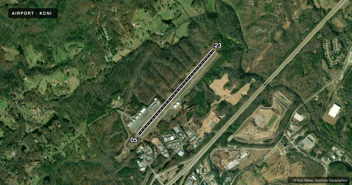
Airport sketch
Runways drawn to scale from FAA survey coordinates, rendered over satellite imagery. Not for navigation.
Approaches & charts
Services on the field
Fuel grades, oxygen, maintenance, ramp storage and lighting — as declared to the FAA by the airport operator.
Fuel & services
- Fuel
- 100LLA+
- Oxygen (bottled)
- HIGH/LOW
- Oxygen (bulk)
- HIGH/LOW
- Airframe repair
- Major
- Power plant repair
- Major
- Other services
- CHTR,INSTR,RNTL
Ramp & ground
- Transient storage
- Tie-down
- Landing fee
- No fee published
- Customs
- Not available
- Lighting schedule
- SEE RMK
- Beacon schedule
- SS-SR
- Beacon
- White / Green (civil land)(WG)
- Wind indicator
- Lighted
- Segmented circle
- Yes
Fuel & FBOs
Cheapest 100LL and Jet A on the field and nearby. Always confirm with the FBO before taxi.
Airport notes
Surface conditions, obstructions, local procedures, lighting outages and other notes published with each FAA cycle.
General notes
- FOR APCH/DEP SVC SOUTH OF CNI CTC ATLANTA TRACON OR AT 678-364-6131. FOR APCH/DEP SVC NORTH OF CNI CTC ATLANTA ARTCC AT 770-210-7692.
- FOR NOISE ABATEMENT RWY 23 PREF.
- RDO TRANSMISSIONS FROM THE DEP END OF RWY 23 MAY NOT BE RELBL DUE TO TRRN.
Lighting notes
- ACTVT REIL RWY 05 & 23; PAPI RWY 05 & 23; HIRL RWY 05/23 - CTAF
VFR map & nearby airports
VFR sectional. Tap any ICAO chip to open that airport.
Key facts · KCNI
Answer card- ICAO
- KCNI
- Name
- CHEROKEE COUNTY RGNL
- Location
- CANTON, GEORGIA
- Elevation
- 1,219.8 ft MSL
- Traffic pattern altitude
- 2,219.8 ft MSL (1,000 AGL)
- Control tower
- Non-towered (use CTAF)
- Total runways
- 1
- Longest runway
- 05/23 · 5,003 ft
- Published ILS approaches
- 0
- Published frequencies
- 4
- Magnetic variation
- 5°
- Current flight rules
- VFR
- Current wind
- 260° at 4 kt
- Favored runway now
- RWY 23
Cherokee County Rgnl sits in Canton, Georgia. Field elevation is 1,219.8 ft MSL. The airport has one runway. Runway 05/23 is 5,003 ft long with an asphalt surface. There is no control tower. Traffic uses CTAF 123.0 or UNICOM 123.0.
No ILS approaches are published here. The pattern altitude is not published in the facts, so use the standard 1,000 ft AGL for light piston operations unless the current FAA Chart Supplement says otherwise. That puts the pattern at about 2,220 ft MSL based on the listed field elevation.
S & S Aviation is on the field. It carries 100LL and Jet A. Call (678) 454-2090 for current services before you go. Published remarks say runway 23 is preferred for noise abatement. They also note that radio calls from the departure end of runway 23 may be unreliable because of terrain. The runway has high intensity lights, runway end identifier lights and precision approach path indicators.
For approach and departure service, Atlanta TRACON handles the south side of the field. Atlanta ARTCC handles the north side. This is a good airport to brief carefully before arrival. Terrain and radio coverage matter here, especially if you are departing runway 23 or operating after dark.