METAR & TAF KRYY
Current METAR
Observed 09:50Z
KRYY 270950Z AUTO 00000KT 9SM CLR 24/23 A2993 RMK AO2 SLP121 T02440233 PNO $
- Wind
- 000° @ 0 kt
- Visibility
- 9 SM
- Temp / Dew
- 24°C / 23°C
- Altimeter
- 29.93 inHg
- Clouds
- CLR
- Density alt
- 2,358 ft
- Ceiling
- Unlimited
- Rules
- VFR
Airport info & contacts
Manager on record, flight service, ARTCC, attendance schedule and pattern altitude — published by the FAA and refreshed every 28 days.
Location
- From city
- 21 NM NW
- VFR sectional
- ATLANTA
- ARTCC
- ZTL · ATLANTA
- NOTAM facility
- RYY (NOTAM-D)
Airport manager
- Name
- STEVEN SPENCER
- Phone
- 770-528-8220
- Address
- 1723 MCCOLLUM PKWY BLDG 100, KENNESAW GA 30144
Flight service · Hours
- FSS MCN
- MACON1-800-WX-BRIEF
- Attendance
- 0600-0000
Frequencies
Tap any row to copy the frequency to your clipboard.
Runways & pattern
Full pagePattern entry · RWY 09
RIGHT TRAFFICRunway end performance
| End | TORA | TODA | ASDA | LDA | VGSI | Approach lights | Obstruction |
|---|---|---|---|---|---|---|---|
| 09 | 6,311' | 6,311' | 6,311' | 5,233' | PAPI 4-box left(4°) | — | 26', road, 1' from thr, 381' R of cntrln, slope 0 |
| 27 | 6,311' | 6,311' | 5,374' | 5,374' | PAPI 4-box left(3°) | MALSF | 37', trees, 722' from thr, 314' R of cntrln, slope 14 |
Declared distances in feet. TORA = takeoff run available, TODA = takeoff distance, ASDA = accelerate-stop, LDA = landing distance.
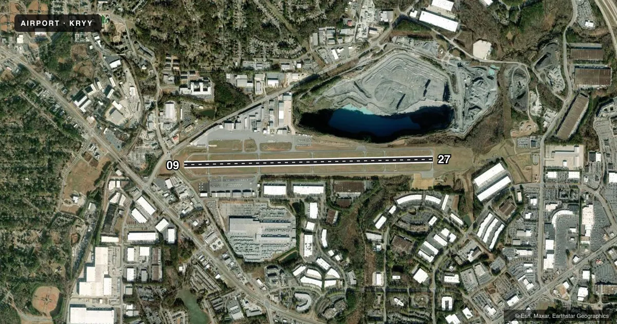
Airport sketch
Runways drawn to scale from FAA survey coordinates, rendered over satellite imagery. Not for navigation.
Approaches & charts
ILS · 1
Services on the field
Fuel grades, oxygen, maintenance, ramp storage and lighting — as declared to the FAA by the airport operator.
Fuel & services
- Fuel
- 100LLA+
- Oxygen (bottled)
- Not available
- Oxygen (bulk)
- HIGH/LOW
- Airframe repair
- Major
- Power plant repair
- Major
- Other services
- AMB,AVNCS,CHTR,INSTR,RNTL,SALES
Ramp & ground
- Transient storage
- Tie-down
- Hangar
- Landing fee
- Yes
- Customs
- Not available
- Lighting schedule
- SEE RMK
- Beacon schedule
- SS-SR
- Beacon
- White / Green (civil land)(WG)
- Wind indicator
- Lighted
- Segmented circle
- Yes
Fuel & FBOs
Cheapest 100LL and Jet A on the field and nearby. Always confirm with the FBO before taxi.
Airport notes
Surface conditions, obstructions, local procedures, lighting outages and other notes published with each FAA cycle.
General notes
- BLASTING SR-SS MON-FRI 2000 FT AER 27.
- ARPT MOWING IN PROGRESS SPRING THRU AUTUMN.
- COYOTES ON & INVOF ARPT.
- RY 9 IS CALM WIND RY IN VFR CONDS.
- NORTH APRON AT TWY A-1 CONNECTOR IS RESTRICTED TO GROUP 1 AFCT ONLY.
- TWY B CLSD FM TWY B5 TO B6 TO ACFT WITH WINGSPANS OF 79 FT OR GTR.
- TURBINE/JET AIRCRAFT OPERATORS ARE REQUESTED TO USE NBAA NOISE ABATEMENT PROGRAM PROCEDURES OR COMPARABLE PROCEDURES OF AIRCRAFT MANUFACTURER.
- INT'L OPS ARPT OF ENTRY - USER FEE AIRPORT
Lighting notes
- WHEN ATCT CLSD, ACTVT MALSF RWY 27; HIRL RWY 09/27 - CTAF.
Approach & departure obstructions
- 09ROAD 0-200 FROM RUNWAY END, 380' RIGHT AND 180' LEFT.
- 09RY 09 APCH RATIO 19:1 TO DSPLCD THLD. +85FT TREES, 1395FT 532B LEFT
Other notes
- INDEX B AIRCRAFT RESCUE AND FIRE FIGHTING EQUIPMENT AVAILABLE UPON REQUEST. 24 HOUR PRIOR PERMISSION REQUIRED. CONTACT AIRPORT MANAGER 770-528-1615.
- LDG FEE FOR TSNT ACFT OVER 6000 LBS AND ALL TSNT ACFT BTWN 2100L-0600L.
VFR map & nearby airports
VFR sectional. Tap any ICAO chip to open that airport.
Key facts · KRYY
Answer card- ICAO
- KRYY
- Name
- COBB COUNTY INTL/MCCOLLUM FLD
- Location
- ATLANTA, GEORGIA
- Elevation
- 1,040.4 ft MSL
- Traffic pattern altitude
- 2,040.4 ft MSL (1,000 AGL)
- Control tower
- Towered · 0700-2300
- Total runways
- 1
- Longest runway
- 09/27 · 6,295 ft
- Published ILS approaches
- 1
- Published frequencies
- 10
- Magnetic variation
- 4°
- Current flight rules
- VFR
- Current wind
- 000° at 0 kt
- Favored runway now
- –
Cobb County Intl/McCollum Field is in Atlanta, Georgia. The field elevation is 1,040.4 ft MSL. It has one runway. Runway 09/27 is 6,295 ft long, so it is the one to plan around for performance and taxi flow. The airport has a control tower. Tower hours are 0700-2300 local. One ILS approach is published for runway 27. The pattern altitude is not published in the facts. Use the current FAA Chart Supplement before you fly. Ascension FBO is on the field. It carries 100LL, Jet A and Jet A Prist. This is an international airport of entry with user fee status. Customs and arrival planning matter if you are coming from outside the country. The published remarks also call out turbine and jet noise abatement guidance. They also mention blasting near runway 27 during the day on weekdays. A road is close to the runway 09 end. The north apron at the taxiway A-1 connector is restricted to group 1 aircraft only. Taxiway B is closed from B5 to B6 for aircraft with wingspans of 79 ft or greater. Expect a busy airport environment. Check current airport notes before arrival if you are operating a larger aircraft or planning a late arrival.