METAR & TAF 4A4
4A4 does not publish a METAR.
Showing the nearest reporting station: KPUJ (PAULDING NORTHWEST ATLANTA) · 12.0 NM away. Conditions at 4A4 may differ.
METAR · KPUJ
Observed 03:15Z
KPUJ 270315Z AUTO 32007KT 9SM CLR 26/25 A2997 RMK AO2
- Wind
- 320° @ 7 kt
- Visibility
- 9 SM
- Temp / Dew
- 26°C / 25°C
- Altimeter
- 29.97 inHg
- Clouds
- CLR
- Density alt
- 2,465 ft
- Ceiling
- Unlimited
- Rules
- VFR
Airport info & contacts
Manager on record, flight service, ARTCC, attendance schedule and pattern altitude — published by the FAA and refreshed every 28 days.
Location
- From city
- 5 NM E
- VFR sectional
- ATLANTA
- ARTCC
- ZTL · ATLANTA
- NOTAM facility
- MCN (NOTAM-D)
Airport manager
- Name
- CHUCK BEAVERS
- Phone
- 770-684-7136
- Address
- 500 AIRPORT ROAD, 144 WEST AVE, CEDARTOWN GA 30125
Flight service · Hours
- FSS MCN
- MACON1-800-WX-BRIEF
- Attendance
- 0900-1700
Frequencies
Tap any row to copy the frequency to your clipboard.
Runways & pattern
Full pagePattern entry · RWY 28
LEFT TRAFFICRunway end performance
| End | TORA | TODA | ASDA | LDA | VGSI | Approach lights | Obstruction |
|---|---|---|---|---|---|---|---|
| 10 | — | — | — | — | PAPI 2-box left(3°) | — | — |
| 28 | — | — | — | — | PAPI 2-box left(3°) | — | 26', trees, 356' from thr, 227' R of cntrln, slope 6 |
Declared distances in feet. TORA = takeoff run available, TODA = takeoff distance, ASDA = accelerate-stop, LDA = landing distance.
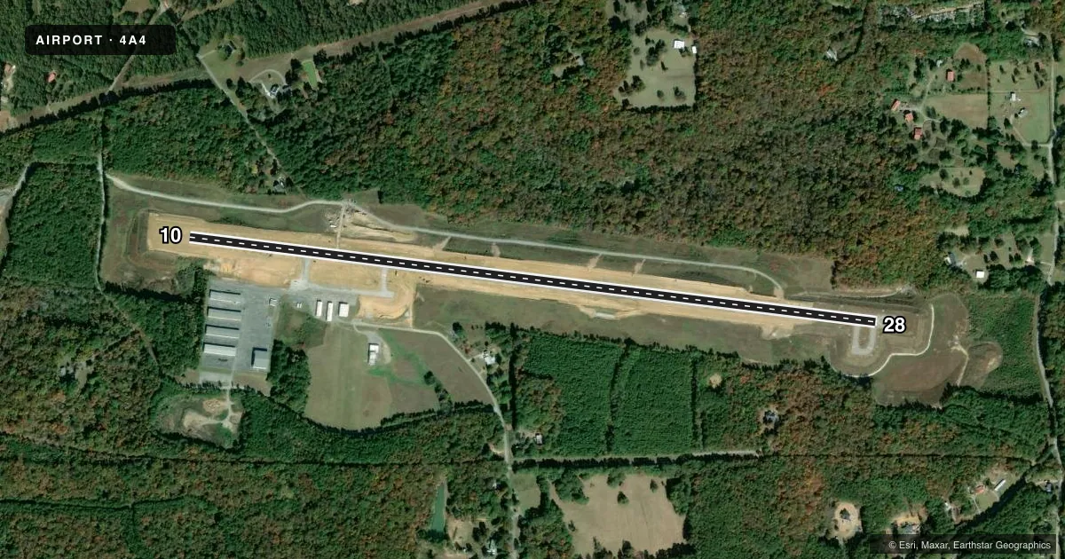
Airport sketch
Runways drawn to scale from FAA survey coordinates, rendered over satellite imagery. Not for navigation.
Approaches & charts
Services on the field
Fuel grades, oxygen, maintenance, ramp storage and lighting — as declared to the FAA by the airport operator.
Fuel & services
- Fuel
- 100LLA
- Oxygen (bottled)
- Not available
- Oxygen (bulk)
- Not available
- Airframe repair
- Not available
- Power plant repair
- Not available
- Other services
- PAJA
Ramp & ground
- Transient storage
- Tie-down
- Landing fee
- No fee published
- Customs
- Not available
- Lighting schedule
- SEE RMK
- Beacon schedule
- SS-SR
- Beacon
- White / Green (civil land)(WG)
- Wind indicator
- No
- Segmented circle
- Yes
Fuel & FBOs
Cheapest 100LL and Jet A on the field and nearby. Always confirm with the FBO before taxi.
Airport notes
Surface conditions, obstructions, local procedures, lighting outages and other notes published with each FAA cycle.
General notes
- DEER & BIRDS ON & INVOF OF ARPT.
- EXTENSIVE PARACHUTE ACTIVITY ON WEEKENDS - AVOID OVERFLIGHTS OF ARPT.
- FOR CD CTC ATLANTA ARTCC AT 770-210-7692.
- MNT CTAF FREQ AND FRQLY BCST LCTN AND INTNS FOR RWY USE DUE TO NO LINE OF SIGHT BTN RWY ENDS.
- RWY 10 IS THE PREFERRED DEP RWY DURG CALM WINDS.
Lighting notes
- ACTVT PAPI RWY 10 & 28; MIRL RWY 10/28 - CTAF.
Other notes
- MANAGERFBO 770-684-7136.
VFR map & nearby airports
VFR sectional. Tap any ICAO chip to open that airport.
Key facts · 4A4
Answer card- ICAO
- 4A4
- Name
- POLK COUNTY/CORNELIUS MOORE FLD
- Location
- CEDARTOWN, GEORGIA
- Elevation
- 973.7 ft MSL
- Traffic pattern altitude
- 1,973.7 ft MSL (1,000 AGL)
- Control tower
- Non-towered (use CTAF)
- Total runways
- 1
- Longest runway
- 10/28 · 5,060 ft
- Published ILS approaches
- 0
- Published frequencies
- 2
- Magnetic variation
- 5°
- Current flight rules
- VFR
- Current wind
- 320° at 7 kt
- Favored runway now
- RWY 28
Polk County/Cornelius Moore Fld sits in Cedartown, Georgia. The field elevation is 973.7 ft MSL. It has one runway. Runway 10/28 is 5,060 ft long with asphalt pavement. There is no control tower. CTAF and UNICOM are both 122.8.
No ILS approaches are published here. Pattern altitude is not published, so plan on the standard 1,000 ft AGL for light piston operations unless the current Chart Supplement says otherwise. The on-field FBO is Polk County Airport. It carries AVGAS 100LL and JET A. The FBO phone number is (770) 684-7136.
A few operational points matter here. Weekend parachute activity is extensive, so avoid overflights of the airport. Deer and birds are reported on and near the field. There is no line of sight between runway ends. Keep CTAF active. Make frequent position calls with your intentions for runway use. Runway 10 is the preferred departure runway during calm winds. PAPI is available on both runways. Medium intensity runway lighting on 10 and 28 is controlled by CTAF. For a first-time arrival, this is a non-towered field with local traffic discipline that matters. Use the radio early, watch for jump activity and verify any current restrictions with the current FAA Chart Supplement before you go.