METAR & TAF KCZL
Current METAR
Observed 10:15Z
KCZL 271015Z AUTO 30006KT 25/23 A2990 RMK AO2 PWINO LTG DSNT SW AND W
- Wind
- 300° @ 6 kt
- Visibility
- —
- Temp / Dew
- 25°C / 23°C
- Altimeter
- 29.90 inHg
- Clouds
- Clear
- Density alt
- 2,038 ft
- Ceiling
- Unlimited
- Rules
- VFR
Airport info & contacts
Manager on record, flight service, ARTCC, attendance schedule and pattern altitude — published by the FAA and refreshed every 28 days.
Location
- From city
- 3 NM S
- VFR sectional
- ATLANTA
- ARTCC
- ZTL · ATLANTA
- NOTAM facility
- MCN (NOTAM-D)
Airport manager
- Name
- DWIGHT ALBRITTON
- Phone
- 706-602-8000
- Address
- 1957 HWY 41 S, CALHOUN GA 30701
Flight service · Hours
- FSS MCN
- MACON1-800-WX-BRIEF
- Attendance
- NOV-MAR · 0800-1800
- APR-OCT · 0800-2000
Frequencies
Tap any row to copy the frequency to your clipboard.
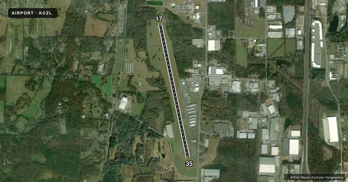
Runways & pattern
Full pagePattern entry · RWY 35
LEFT TRAFFICRunway end performance
| End | TORA | TODA | ASDA | LDA | VGSI | Approach lights | Obstruction |
|---|---|---|---|---|---|---|---|
| 17 | 6,034' | 6,034' | 6,034' | 6,034' | PAPI 4-box left(3.5°) | — | 21', trees, 347' from thr, 220' R of cntrln, slope 7 |
| 35 | 6,034' | 6,034' | 6,034' | 5,648' | PAPI 4-box left(3°) | — | 97', trees, 1752' from thr, 420' R of cntrln, slope 16 |
Declared distances in feet. TORA = takeoff run available, TODA = takeoff distance, ASDA = accelerate-stop, LDA = landing distance.
Airport sketch
Runways drawn to scale from FAA survey coordinates, rendered over satellite imagery. Not for navigation.
Approaches & charts
ILS · 1
Services on the field
Fuel grades, oxygen, maintenance, ramp storage and lighting — as declared to the FAA by the airport operator.
Fuel & services
- Fuel
- 100LLA+
- Oxygen (bottled)
- Not available
- Oxygen (bulk)
- Not available
- Airframe repair
- Major
- Power plant repair
- Major
- Other services
- AMB,INSTR,RNTL,SURV
Ramp & ground
- Transient storage
- Tie-down
- Hangar
- Landing fee
- No fee published
- Customs
- Not available
- Lighting schedule
- SEE RMK
- Beacon schedule
- SS-SR
- Beacon
- White / Green (civil land)(WG)
- Wind indicator
- Lighted
- Segmented circle
- No
Fuel & FBOs
Cheapest 100LL and Jet A on the field and nearby. Always confirm with the FBO before taxi.
Airport notes
Surface conditions, obstructions, local procedures, lighting outages and other notes published with each FAA cycle.
General notes
- SELF-SVC FUEL AVBL WITH CREDIT CARD.
- DEER & WILDLIFE ON OR INVOF ARPT.
- FOR CD CTC ATLANTA ARTCC AT 770-210-7692.
Lighting notes
- ACTVT PAPI RWY 17 & 35; MIRL RWY 17/35 - CTAF. MIRL RWY 17/35 PRESET ON MED INTST DUSK - 2200, TO INCR INTST & ACTVT AFT 2200 - CTAF.
Approach & departure obstructions
- 35APCH SLOPE 20:1 TO DSPLCD THLD, TREES 2172 FT OUT, 318 LEFT.
VFR map & nearby airports
VFR sectional. Tap any ICAO chip to open that airport.
Key facts · KCZL
Answer card- ICAO
- KCZL
- Name
- TOM B DAVID FLD
- Location
- CALHOUN, GEORGIA
- Elevation
- 655.8 ft MSL
- Traffic pattern altitude
- 1,655.8 ft MSL (1,000 AGL)
- Control tower
- Non-towered (use CTAF)
- Total runways
- 1
- Longest runway
- 17/35 · 6,034 ft
- Published ILS approaches
- 1
- Published frequencies
- 2
- Magnetic variation
- 5°
- Current flight rules
- VFR
- Current wind
- 300° at 6 kt
- Favored runway now
- RWY 35
Tom B David Fld is in Calhoun, Georgia. The field elevation is 655.8 ft MSL. It has one runway, 17/35, which is 6,034 ft long with an asphalt surface. There is no control tower. CTAF and UNICOM are both 122.8. The published pattern altitude is not listed, so use the standard 1,000 ft AGL unless ATC or the current Chart Supplement says otherwise.
The airport has one ILS approach to runway 35. The runway lights are medium intensity and are tied to CTAF. They are preset to medium intensity from dusk to 2200. After 2200, use CTAF to increase intensity and turn them on. The precision approach path indicator is active for runways 17 and 35. The published remarks also note deer and wildlife in the airport area. Keep a sharp scan on taxi, takeoff and landing.
Calhoun-Gordon County Airport Authority is the on-field FBO. It carries AVGAS 100LL and Jet A Prist. Self-service fuel is available with a credit card. For clearance delivery, contact Atlanta Air Route Traffic Control Center at 770-210-7692. The runway 35 approach has a published tree obstruction note. Brief that side carefully if you are planning the ILS or a night arrival.