METAR & TAF 1A3
1A3 does not publish a METAR.
Showing the nearest reporting station: KDZJ (BLAIRSVILLE) · 19.7 NM away. Conditions at 1A3 may differ.
METAR · KDZJ
Observed 05:15Z
KDZJ 270515Z AUTO 00000KT 5SM BR CLR 22/22 A3003 RMK AO2 T02160215
- Wind
- 000° @ 0 kt
- Visibility
- 5 SM
- Temp / Dew
- 22°C / 22°C
- Altimeter
- 30.03 inHg
- Clouds
- CLR
- Density alt
- 2,922 ft
- Ceiling
- Unlimited
- Rules
- MVFR
Airport info & contacts
Manager on record, flight service, ARTCC, attendance schedule and pattern altitude — published by the FAA and refreshed every 28 days.
Location
- From city
- 3 NM NE
- VFR sectional
- ATLANTA
- ARTCC
- ZTL · ATLANTA
- NOTAM facility
- BNA (NOTAM-D)
Airport manager
- Name
- ALAN FROSCH
- Phone
- 423-496-9465
- Address
- 971 AIRPORT ROAD, COPPERHILL TN 37317
Flight service · Hours
- FSS BNA
- NASHVILLE1-800-WX-BRIEF
- Attendance
- IRREG
Frequencies
Tap any row to copy the frequency to your clipboard.
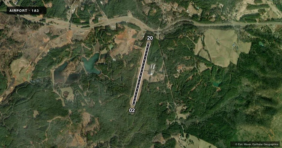
Runways & pattern
Full pagePattern entry · RWY 02
LEFT TRAFFICRunway end performance
| End | TORA | TODA | ASDA | LDA | VGSI | Approach lights | Obstruction |
|---|---|---|---|---|---|---|---|
| 02 | 3,500' | 3,500' | 3,360' | 3,270' | PAPI 2-box left(3°) | — | — |
| 20 | 3,270' | 3,500' | 3,410' | 3,270' | PAPI 2-box left(4°) | — | — |
Declared distances in feet. TORA = takeoff run available, TODA = takeoff distance, ASDA = accelerate-stop, LDA = landing distance.
Airport sketch
Runways drawn to scale from FAA survey coordinates, rendered over satellite imagery. Not for navigation.
Approaches & charts
Services on the field
Fuel grades, oxygen, maintenance, ramp storage and lighting — as declared to the FAA by the airport operator.
Fuel & services
- Fuel
- 100LL
- Airframe repair
- Major
- Power plant repair
- Major
- Other services
- INSTR
Ramp & ground
- Transient storage
- Tie-down
- Hangar
- Landing fee
- No fee published
- Customs
- Not available
- Lighting schedule
- SEE RMK
- Beacon schedule
- SS-SR
- Beacon
- White / Green (civil land)(WG)
- Wind indicator
- Lighted
- Segmented circle
- Yes
Fuel & FBOs
Cheapest 100LL and Jet A on the field and nearby. Always confirm with the FBO before taxi.
Airport notes
Surface conditions, obstructions, local procedures, lighting outages and other notes published with each FAA cycle.
General notes
- WILDLIFE INVOF RWY.
- FOR CD CTC ATLANTA ARTCC AT 770-210-7692.
Lighting notes
- ACTVT NON STANDARD LIRL RWY 02/20 - CTAF.
Fuel notes
- 100LLFUEL 24 HR CREDIT CARD SVC AVBL.
Approach & departure obstructions
- 02APCH RATIO 17:1 TO DTHR.
- 20APCH RATIO 19:1 TO DTHR.
- 208400 FT MTN RIDGES IN APCH; 5000 FT MTN RIDGE ALONG E SIDE OF RWY.
Other notes
- AIRFRAME RPR NEXT DOOR, ON CALL 706-490-4143
VFR map & nearby airports
VFR sectional. Tap any ICAO chip to open that airport.
Key facts · 1A3
Answer card- ICAO
- 1A3
- Name
- MARTIN CAMPBELL FLD
- Location
- COPPERHILL, TENNESSEE
- Elevation
- 1,789 ft MSL
- Traffic pattern altitude
- 2,789 ft MSL (1,000 AGL)
- Control tower
- Non-towered (use CTAF)
- Total runways
- 1
- Longest runway
- 02/20 · 3,500 ft
- Published ILS approaches
- 0
- Published frequencies
- 1
- Magnetic variation
- 5°
- Current flight rules
- MVFR
- Current wind
- 000° at 0 kt
- Favored runway now
- –
Martin Campbell Fld (1A3) sits in Copperhill, Tennessee. The field elevation is 1,789 ft MSL. It has one runway, 02/20, which is 3,500 ft long and asphalt. There is no control tower. CTAF is 122.9. No ILS approaches are published here.
Pattern altitude is not published. Use the standard 1,000 ft AGL pattern unless the current Chart Supplement says otherwise. Whitewater Aviation Corporation is on the field. It carries 100LL. Fuel with 24-hour credit card service is available. The airport also notes non-standard low intensity runway lighting on 02/20 that is activated by CTAF.
This is a mountain airport, so terrain matters. Published remarks call out 8,400 ft ridges in the approach area. There is also a 5,000 ft ridge along the east side of runway 20. The approach clearance slopes are tight on both ends. Wildlife is also reported in the runway area. If you are new to the field, brief the terrain, the lighting and the CTAF lighting activation before arrival. For clearance delivery, contact Atlanta ARTCC. Airframe repair is next door and available on call.