METAR & TAF KMMI
Current METAR
Observed 08:15Z
KMMI 270815Z AUTO 22004KT 6SM BR FEW042 FEW050 25/25 A2989 RMK A01
- Wind
- 220° @ 4 kt
- Visibility
- 6 SM
- Temp / Dew
- 25°C / 25°C
- Altimeter
- 29.89 inHg
- Clouds
- FEW
- Density alt
- 2,321 ft
- Ceiling
- Unlimited
- Rules
- VFR
Airport info & contacts
Manager on record, flight service, ARTCC, attendance schedule and pattern altitude — published by the FAA and refreshed every 28 days.
Location
- From city
- 3 NM SE
- VFR sectional
- ATLANTA
- ARTCC
- ZTL · ATLANTA
- NOTAM facility
- BNA (NOTAM-D)
Airport manager
- Name
- KRISTY GENTRY COX
- Phone
- 423-745-4939
- Address
- 195 COUNTY ROAD 552, ATHENS TN 37303
Flight service · Hours
- FSS BNA
- NASHVILLE1-800-WX-BRIEF
- Attendance
- SUN · 1230-1700
- MON-SAT · 0830-1700
Frequencies
Tap any row to copy the frequency to your clipboard.
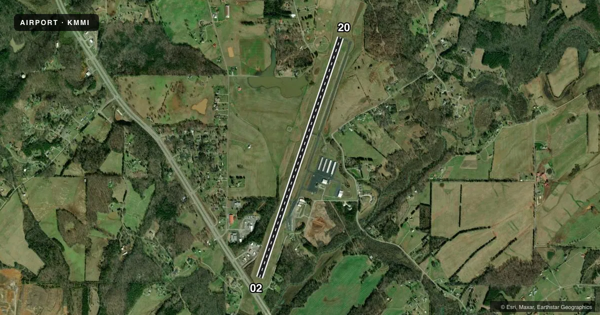
Runways & pattern
Full pagePattern entry · RWY 20
LEFT TRAFFICRunway end performance
| End | TORA | TODA | ASDA | LDA | VGSI | Approach lights | Obstruction |
|---|---|---|---|---|---|---|---|
| 02 | — | — | — | — | PAPI 2-box left(3°) | — | 77', trees, 1187' from thr, 142' R of cntrln, slope 12 |
| 20 | — | — | — | — | PAPI 2-box left(3°) | — | 96', trees, 2041' from thr, 178' R of cntrln, slope 19 |
Declared distances in feet. TORA = takeoff run available, TODA = takeoff distance, ASDA = accelerate-stop, LDA = landing distance.
Airport sketch
Runways drawn to scale from FAA survey coordinates, rendered over satellite imagery. Not for navigation.
Approaches & charts
Services on the field
Fuel grades, oxygen, maintenance, ramp storage and lighting — as declared to the FAA by the airport operator.
Fuel & services
- Fuel
- 100LLA+
- Other services
- INSTR
Ramp & ground
- Transient storage
- Tie-down
- Hangar
- Landing fee
- No fee published
- Customs
- Not available
- Lighting schedule
- SS-SR
- Beacon schedule
- SS-SR
- Beacon
- White / Green (civil land)(WG)
- Wind indicator
- Lighted
- Segmented circle
- Yes
Fuel & FBOs
Cheapest 100LL and Jet A on the field and nearby. Always confirm with the FBO before taxi.
Airport notes
Surface conditions, obstructions, local procedures, lighting outages and other notes published with each FAA cycle.
General notes
- WILDLIFE ON & INVOF ARPT.
- FOR CD CTC KNOXVILLE APCH AT 865-980-3034; IF UNA FOR CD CTC KNOXVILLE APCH AT 865-980-3033.
Approach & departure obstructions
- 02FADED.
- 20FADED.
- 02PAPI UNUSBL BYD 7 DEGS LEFT OF CNTRLN.
- 02APCH SLOPE 36:1 TO DTHR.
Other notes
- 1CLD EASTER, THANKSGIVING & CHRISTMAS.
VFR map & nearby airports
VFR sectional. Tap any ICAO chip to open that airport.
Key facts · KMMI
Answer card- ICAO
- KMMI
- Name
- MCMINN COUNTY
- Location
- ATHENS, TENNESSEE
- Elevation
- 874.3 ft MSL
- Traffic pattern altitude
- 1,874.3 ft MSL (1,000 AGL)
- Control tower
- Non-towered (use CTAF)
- Total runways
- 1
- Longest runway
- 02/20 · 6,450 ft
- Published ILS approaches
- 0
- Published frequencies
- 4
- Magnetic variation
- 3°
- Current flight rules
- VFR
- Current wind
- 220° at 4 kt
- Favored runway now
- RWY 20
McMinn County Airport sits in Athens, Tennessee. The field elevation is 874.3 ft MSL. It has one asphalt runway, 02/20, at 6,450 ft. There is no control tower. CTAF and UNICOM are both 122.8. Knoxville Approach handles radar services on 123.9 or 353.6.
No ILS approaches are published here. The pattern altitude is not published in the facts. Use the standard 1,000 ft AGL pattern for light piston operations unless the current Chart Supplement says otherwise. The airport has one on-field FBO, Athens Air. It carries 100LL and Jet A. Call (423) 745-4939 before arrival if you need current service details.
A few published remarks matter on a first visit. Runway 02 has a displaced threshold with a 36 to 1 approach slope to that threshold. Runway 02 and runway 20 both have faded markings. The PAPI on runway 02 is unusable beyond 7 degrees left of centerline. Wildlife is reported on and near the airport. The field is closed Easter, Thanksgiving and Christmas. For clearance delivery, contact Knoxville Approach at 865-980-3034. If that does not work, use 865-980-3033. Athens is not a towered field. Plan your arrival with the current Chart Supplement and be ready for local traffic on CTAF.