METAR & TAF 2A0
Current METAR
Observed 08:15Z
K2A0 270815Z AUTO 00000KT 8SM CLR 25/25 A2985 RMK A01
- Wind
- 000° @ 0 kt
- Visibility
- 8 SM
- Temp / Dew
- 25°C / 25°C
- Altimeter
- 29.85 inHg
- Clouds
- CLR
- Density alt
- 2,177 ft
- Ceiling
- Unlimited
- Rules
- VFR
Airport info & contacts
Manager on record, flight service, ARTCC, attendance schedule and pattern altitude — published by the FAA and refreshed every 28 days.
Location
- From city
- 4 NM E
- VFR sectional
- ATLANTA
- ARTCC
- ZTL · ATLANTA
- NOTAM facility
- BNA (NOTAM-D)
Airport manager
- Name
- BRYAN JANISCH
- Phone
- 423-775-8407
- Address
- 350 WALTER SQUIRE RD, DAYTON TN 37321
Flight service · Hours
- FSS BNA
- NASHVILLE1-800-WX-BRIEF
- Attendance
- MON-SAT · 0900-1700
- SUN · 1300-1700
Frequencies
Tap any row to copy the frequency to your clipboard.
Runways & pattern
Full pagePattern entry · RWY 03
LEFT TRAFFICRunway end performance
| End | TORA | TODA | ASDA | LDA | VGSI | Approach lights | Obstruction |
|---|---|---|---|---|---|---|---|
| 03 | — | — | — | — | PAPI 2-box left(3°) | — | 21', tree, 810' from thr, 69' R of cntrln, slope 29 |
| 21 | — | — | — | — | PAPI 2-box left(3°) | — | 86', tree, 2360' from thr, 572' R of cntrln, slope 25 |
Declared distances in feet. TORA = takeoff run available, TODA = takeoff distance, ASDA = accelerate-stop, LDA = landing distance.
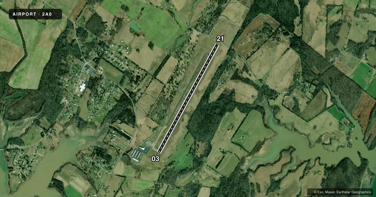
Airport sketch
Runways drawn to scale from FAA survey coordinates, rendered over satellite imagery. Not for navigation.
Approaches & charts
Services on the field
Fuel grades, oxygen, maintenance, ramp storage and lighting — as declared to the FAA by the airport operator.
Fuel & services
- Fuel
- 100LLA+
- Airframe repair
- Major
- Power plant repair
- Major
- Other services
- AVNCS,INSTR
Ramp & ground
- Transient storage
- Tie-down
- Landing fee
- No fee published
- Customs
- Not available
- Lighting schedule
- SS-SR
- Beacon schedule
- SS-SR
- Beacon
- White / Green (civil land)(WG)
- Wind indicator
- Lighted
- Segmented circle
- Yes
Fuel & FBOs
Cheapest 100LL and Jet A on the field and nearby. Always confirm with the FBO before taxi.
Airport notes
Surface conditions, obstructions, local procedures, lighting outages and other notes published with each FAA cycle.
General notes
- FOR CD CTC CHATTANOOGA APCH AT 423-855-6478, WHEN APCH CLSD CTC ATLANTA ARTCC AT 770-210-7692.
- WILDLIFE INVOF ARPT.
Fuel notes
- 100LLSELF SVC.
Other notes
- THIS AIRPORT HAS BEEN SURVEYED BY THE NATIONAL GEODETIC SURVEY.
- 1CLSD FED HOL. AFT HR TRML DOOR CODE - UNICOM.
VFR map & nearby airports
VFR sectional. Tap any ICAO chip to open that airport.
Key facts · 2A0
Answer card- ICAO
- 2A0
- Name
- MARK ANTON
- Location
- DAYTON, TENNESSEE
- Elevation
- 718.2 ft MSL
- Traffic pattern altitude
- 1,718.2 ft MSL (1,000 AGL)
- Control tower
- Non-towered (use CTAF)
- Total runways
- 1
- Longest runway
- 03/21 · 5,001 ft
- Published ILS approaches
- 0
- Published frequencies
- 4
- Magnetic variation
- 4°
- Current flight rules
- VFR
- Current wind
- 000° at 0 kt
- Favored runway now
- –
Mark Anton Airport sits in Dayton, Tennessee. Field elevation is 718.2 ft MSL. The airport has one runway. Runway 03/21 is 5,001 ft long with asphalt pavement. The runway headings are 29° and 209° magnetic. There is no control tower. CTAF and UNICOM are both 123.0. Chattanooga Approach handles APCH and DEP on 125.1 and 379.1. No ILS approaches are published here.
The published pattern altitude is not listed. Use the standard 1,000 ft AGL pattern unless local guidance says otherwise. For this field that works out to about 1,718 ft MSL. Mark Anton Airport carries AVGAS 100LL and JET A. Self-serve 100LL fuel is available. The on-field FBO is Mark Anton Airport. Its phone number is (423) 775-8407.
A few published remarks matter for planning. Wildlife is reported in the vicinity of the airport. The airport is closed on federal holidays. After hours terminal access uses a door code available on UNICOM. For clearance delivery, contact Chattanooga Approach at 423-855-6478. If approach is closed, contact Atlanta ARTCC at 770-210-7692. First-time visitors should also brief the lack of tower service and the nearby terrain and traffic picture before arrival.