METAR & TAF KFGU
KFGU does not publish a METAR.
Showing the nearest reporting station: KCHA (LOVELL FLD) · 9.0 NM away. Conditions at KFGU may differ.
METAR · KCHA
Observed 10:53Z
KCHA 271053Z COR 28006KT 10SM FEW018 SCT039 SCT090 BKN130 26/23 A2993 RMK AO2 SLP126 T02560228 $
- Wind
- 280° @ 6 kt
- Visibility
- 10 SM
- Temp / Dew
- 26°C / 23°C
- Altimeter
- 29.93 inHg
- Clouds
- BKN
- Density alt
- 2,374 ft
- Ceiling
- 13,000 ft AGL
- Rules
- VFR
Airport info & contacts
Manager on record, flight service, ARTCC, attendance schedule and pattern altitude — published by the FAA and refreshed every 28 days.
Location
- From city
- 2 NM SE
- VFR sectional
- ATLANTA
- Pattern altitude
- 1,040 ft AGL · 1,900 ft MSL
- ARTCC
- ZTL · ATLANTA
- NOTAM facility
- BNA (NOTAM-D)
Airport manager
- Name
- RYAN BYFORD
- Phone
- 423-468-1988
- Address
- P.O. BOX 1880, COLLEGEDALE TN 37315-1880
Flight service · Hours
- FSS BNA
- NASHVILLE1-800-WX-BRIEF
- Attendance
- MON - FRI · 0830-1730
- SAT-SUN · 0830-1400
Frequencies
Tap any row to copy the frequency to your clipboard.
Runways & pattern
Full pagePattern entry · RWY 21
LEFT TRAFFICRunway end performance
| End | TORA | TODA | ASDA | LDA | VGSI | Approach lights | Obstruction |
|---|---|---|---|---|---|---|---|
| 03 | 4,986' | 4,986' | 4,986' | 4,586' | VASI 2-box left(3°) | — | 91', trees, 1102' from thr, 217' R of cntrln, slope 9 |
| 21 | 4,986' | 4,986' | 4,586' | 4,586' | VASI 2-box left(3°) | — | 53', trees, 1130' from thr, 45' R of cntrln, slope 17 |
Declared distances in feet. TORA = takeoff run available, TODA = takeoff distance, ASDA = accelerate-stop, LDA = landing distance.
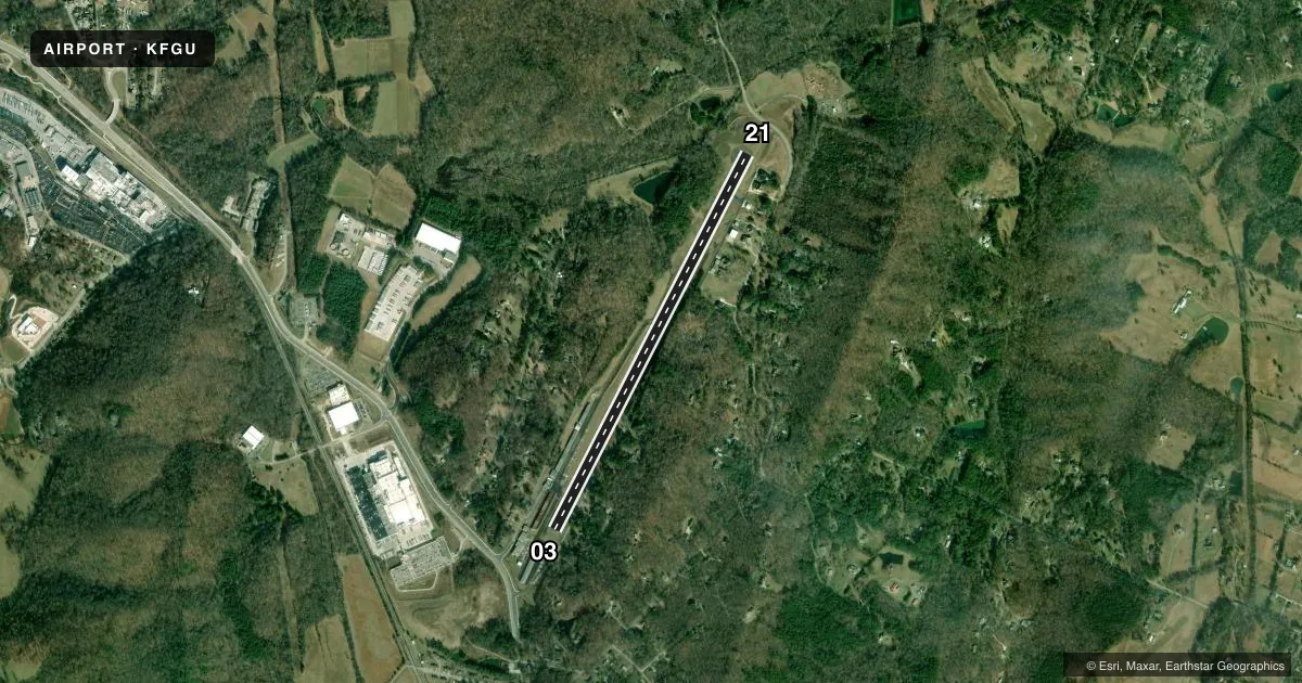
Airport sketch
Runways drawn to scale from FAA survey coordinates, rendered over satellite imagery. Not for navigation.
Approaches & charts
Services on the field
Fuel grades, oxygen, maintenance, ramp storage and lighting — as declared to the FAA by the airport operator.
Fuel & services
- Fuel
- 100LLA
- Airframe repair
- Major
- Power plant repair
- Major
- Other services
- INSTR,RNTL
Ramp & ground
- Transient storage
- Tie-down
- Hangar
- Landing fee
- No fee published
- Lighting schedule
- SS-SR
- Beacon schedule
- SS-SR
- Beacon
- White / Green (civil land)(WG)
- Wind indicator
- Lighted
- Segmented circle
- Yes
Fuel & FBOs
Cheapest 100LL and Jet A on the field and nearby. Always confirm with the FBO before taxi.
Airport notes
Surface conditions, obstructions, local procedures, lighting outages and other notes published with each FAA cycle.
General notes
- DEER ON AND INVOF ARPT.
- FOR CD CTC CHATTANOOGA APCH AT 423-855-6478. WHEN APCH CLSD FOR CD CTC ATLANTA ARTCC AT 770-210-7692.
- OPS ON UNAPPROVED SFCS NA.
Runway surface & condition
- 03/21TREES & POWER LINE VIOLATE 7:1 TRANSITIONAL SFC R SIDE OF RWY.
Approach & departure obstructions
- 03APCH RATIO 19:1 FROM DTHR.
- 03RADIO TWR 3.5 NM SW; TREES 1400 FT S.
- 21MOUNTAIN 1.75 NM N.
Other notes
- VFR ONLY
- 1CLSD THANKSGIVING, CHRISTMAS & NEW YEARS DAY.
- 1SVC AFT HR - 423-593-4020
VFR map & nearby airports
VFR sectional. Tap any ICAO chip to open that airport.
Key facts · KFGU
Answer card- ICAO
- KFGU
- Name
- COLLEGEDALE MUNI
- Location
- COLLEGEDALE, TENNESSEE
- Elevation
- 860 ft MSL
- Traffic pattern altitude
- 1,900 ft MSL (1,040 AGL)
- Control tower
- Non-towered (use CTAF)
- Total runways
- 1
- Longest runway
- 03/21 · 4,986 ft
- Published ILS approaches
- 0
- Published frequencies
- 2
- Magnetic variation
- 2°
- Current flight rules
- VFR
- Current wind
- 280° at 6 kt
- Favored runway now
- RWY 21
Collegedale Muni is in Collegedale, Tennessee. The field elevation is 860 ft MSL. It has one runway, 03/21, which is 4,986 ft long. The airport is not towered. CTAF and UNICOM are both 122.7. No ILS approaches are published here.
Pattern altitude is 1,040 ft AGL, which is 1,900 ft MSL. That is the number to use for local traffic, not a computed estimate. The on-field FBO is Collegedale Municipal Airport. It carries 100LL and Jet A. Call ahead at (423) 236-5008 for current service details. Published remarks say service after hours is available by phone. The field is VFR only. Operations on unapproved surfaces are not authorized.
This is a field where terrain and obstructions matter. There is a mountain 1.75 NM north of runway 21. Trees and a power line penetrate the transitional surface on the right side of the runway. There is also a radio tower southwest of the field and trees south of runway 03. Deer are reported on and near the airport. For clearance delivery, contact Chattanooga Approach when it is open. When it is closed, use Atlanta ARTCC. Check the current FAA Chart Supplement before you go for any updated local notes or restrictions.