METAR & TAF 92A
92A does not publish a METAR.
Showing the nearest reporting station: KMMI (MCMINN COUNTY) · 10.4 NM away. Conditions at 92A may differ.
METAR · KMMI
Observed 11:55Z
KMMI 271155Z AUTO 00000KT 6SM BR CLR 25/25 A2995 RMK A01
- Wind
- 000° @ 0 kt
- Visibility
- 6 SM
- Temp / Dew
- 25°C / 25°C
- Altimeter
- 29.95 inHg
- Clouds
- CLR
- Density alt
- 2,117 ft
- Ceiling
- Unlimited
- Rules
- VFR
Airport info & contacts
Manager on record, flight service, ARTCC, attendance schedule and pattern altitude — published by the FAA and refreshed every 28 days.
Location
- From city
- 4 NM NE
- VFR sectional
- ATLANTA
- ARTCC
- ZTL · ATLANTA
- NOTAM facility
- BNA (NOTAM-D)
Airport manager
- Name
- SARAH ARNOLD
- Phone
- 423-338-2000
- Address
- PO BOX 53, HWY 411 NORTH, BENTON TN 37307
Flight service · Hours
- FSS BNA
- NASHVILLE1-800-WX-BRIEF
- Attendance
- MON-THUR · IREG
- FRI-SUN · 1100-1800
Frequencies
Tap any row to copy the frequency to your clipboard.
Runways & pattern
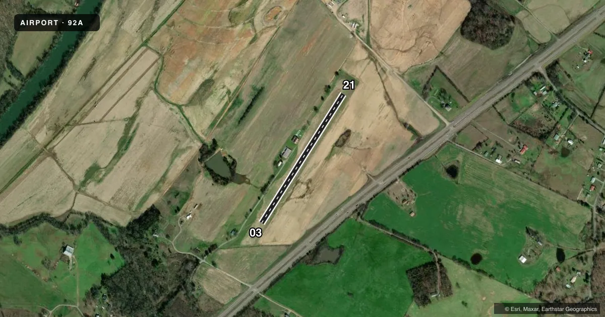
Full pagePattern entry · RWY 03
LEFT TRAFFICAirport sketch
Runways drawn to scale from FAA survey coordinates, rendered over satellite imagery. Not for navigation.
Approaches & charts
Services on the field
Fuel grades, oxygen, maintenance, ramp storage and lighting — as declared to the FAA by the airport operator.
Fuel & services
- Fuel
- Not available
- Other services
- GLD,INSTR,RNTL,TOW
Ramp & ground
- Transient storage
- Tie-down
- Landing fee
- No fee published
- Wind indicator
- Yes
- Segmented circle
- No
Fuel & FBOs
Cheapest 100LL and Jet A on the field and nearby. Always confirm with the FBO before taxi.
Airport notes
Surface conditions, obstructions, local procedures, lighting outages and other notes published with each FAA cycle.
General notes
- GLIDER ACT DURG VFR COND; GLIDER TFC W OF ARPT.
- FOR CD CTC CHATTANOOGA APCH AT 423-855-6478, WHEN APCH CLSD CTC ATLANTA ARTCC AT 770-210-7692.
Runway surface & condition
- 03/21CNTR 50 FT MKD WITH IN GROUND WHITE MKRS.
Approach & departure obstructions
- 21THR MKD WITH WHITE CONES E SIDE.
- 03APCH RATIO 21:1 TO DTHR.
- 21APCH RATIO 69:1 TO DTHR.
Other notes
- VFR ONLY.
- OVERNIGHT TIE DOWN AVBL - AMGR.
- 03/21SFC UNEVEN.
VFR map & nearby airports
VFR sectional. Tap any ICAO chip to open that airport.
Key facts · 92A
Answer card- ICAO
- 92A
- Name
- CHILHOWEE
- Location
- BENTON, TENNESSEE
- Elevation
- 769.3 ft MSL
- Traffic pattern altitude
- 1,769.3 ft MSL (1,000 AGL)
- Control tower
- Non-towered (use CTAF)
- Total runways
- 1
- Longest runway
- 03/21 · 1,938 ft
- Published ILS approaches
- 0
- Published frequencies
- 0
- Magnetic variation
- 2°
- Current flight rules
- VFR
- Current wind
- 000° at 0 kt
- Favored runway now
- –
Chilhowee Airport sits near Benton, Tennessee. Field elevation is 769.3 ft MSL. It has one runway, 03/21, which is 1,938 ft of turf. This is a non-towered field. No ILS approaches are published. Pattern altitude is not published, so use the standard 1,000 ft AGL for light piston traffic unless the current Chart Supplement says otherwise.
This is a VFR-only airport. The runway surface is uneven. The center 50 ft of the runway is marked with in-ground white markers. Runway 03 has a displaced threshold with a published 21 to 1 approach ratio. Runway 21 also has a displaced threshold. Its approach ratio is 69 to 1. Threshold 21 is marked with white cones on the east side.
Glider activity occurs in VFR conditions. The glider traffic is west of the airport. That matters on arrival and departure. Check the pattern and keep your scan outside. For clearance delivery, contact Chattanooga Approach at 423-855-6478. When approach is closed, contact Atlanta ARTCC at 770-210-7692. Overnight tie-down is available through the airport manager. No on-field FBOs are listed, so confirm any services directly before you go.