METAR & TAF KDNN
Current METAR
Observed 05:35Z
KDNN 270535Z AUTO 00000KT 9SM SCT220 25/25 A2995 RMK AO2 T02510251
- Wind
- 000° @ 0 kt
- Visibility
- 9 SM
- Temp / Dew
- 25°C / 25°C
- Altimeter
- 29.95 inHg
- Clouds
- SCT
- Density alt
- 2,042 ft
- Ceiling
- Unlimited
- Rules
- VFR
Airport info & contacts
Manager on record, flight service, ARTCC, attendance schedule and pattern altitude — published by the FAA and refreshed every 28 days.
Location
- From city
- 6 NM SE
- VFR sectional
- ATLANTA
- ARTCC
- ZTL · ATLANTA
- NOTAM facility
- DNN (NOTAM-D)
Airport manager
- Name
- ANDREW WIERSMA
- Phone
- 706-259-2200
- Address
- 4483 AIRPORT ROAD, PO BOX 1205, DALTON GA 30721
Flight service · Hours
- FSS MCN
- MACON1-800-WX-BRIEF
- Attendance
- MON-SAT · 0800-1700
- SUN · 1300-1700
Frequencies
Tap any row to copy the frequency to your clipboard.
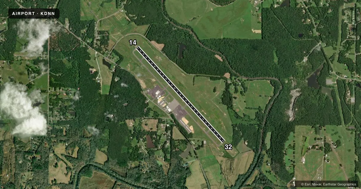
Runways & pattern
Full pagePattern entry · RWY 14
LEFT TRAFFICRunway end performance
| End | TORA | TODA | ASDA | LDA | VGSI | Approach lights | Obstruction |
|---|---|---|---|---|---|---|---|
| 14 | — | — | — | — | PAPI 4-box left(3°) | MALSR | 83', trees, 1198' from thr, 600' R of cntrln, slope 12 |
| 32 | — | — | — | — | PAPI 4-box left(3.05°) | — | 199', trees, 3780' from thr, 774' R of cntrln, slope 18 |
Declared distances in feet. TORA = takeoff run available, TODA = takeoff distance, ASDA = accelerate-stop, LDA = landing distance.
Airport sketch
Runways drawn to scale from FAA survey coordinates, rendered over satellite imagery. Not for navigation.
Approaches & charts
ILS · 1
Services on the field
Fuel grades, oxygen, maintenance, ramp storage and lighting — as declared to the FAA by the airport operator.
Fuel & services
- Fuel
- 100LLA+
- Oxygen (bottled)
- Not available
- Oxygen (bulk)
- Not available
- Airframe repair
- Major
- Power plant repair
- Major
- Other services
- INSTR,RNTL
Ramp & ground
- Transient storage
- Tie-down
- Hangar
- Landing fee
- No fee published
- Customs
- Not available
- Lighting schedule
- SEE RMK
- Beacon schedule
- SS-SR
- Beacon
- White / Green (civil land)(WG)
- Wind indicator
- Lighted
- Segmented circle
- Yes
Fuel & FBOs
Cheapest 100LL and Jet A on the field and nearby. Always confirm with the FBO before taxi.
Airport notes
Surface conditions, obstructions, local procedures, lighting outages and other notes published with each FAA cycle.
General notes
- DEER AND WILDLIFE ON OR INVOF ARPT.
- FOR CD CTC CHATTANOOGA APCH AT 423-855-6478, WHEN APCH CLSD CTC ATLANTA ARTCC AT 770-210-7692.
Lighting notes
- MALSR RWY 14 OPR DUSK-DAWN WHEN THE VIS IS LESS THAN 3 MILES AND/OR THE CEILING IS LESS THAN 1000 FT, OTR TIMES - CTAF. HIRL RWY 14/32 OPR DUSK-DAWN, OTR TIMES - CTAF.
Approach & departure obstructions
- 32RY 32 PAPI UNUSBL BYD 5 DEGREES RIGHT OF RY CNTRLN.
Other notes
- 3OTHER HOURS BY REQUEST, CLOSED MAJOR HOLIDAYS.
VFR map & nearby airports
VFR sectional. Tap any ICAO chip to open that airport.
Key facts · KDNN
Answer card- ICAO
- KDNN
- Name
- DALTON MUNI
- Location
- DALTON, GEORGIA
- Elevation
- 709 ft MSL
- Traffic pattern altitude
- 1,709 ft MSL (1,000 AGL)
- Control tower
- Non-towered (use CTAF)
- Total runways
- 1
- Longest runway
- 14/32 · 5,496 ft
- Published ILS approaches
- 1
- Published frequencies
- 5
- Magnetic variation
- 3°
- Current flight rules
- VFR
- Current wind
- 000° at 0 kt
- Favored runway now
- –
Dalton Muni sits in Dalton, Georgia at 709 ft MSL. It has one runway. Runway 14/32 is 5,496 ft long and asphalt. There is no control tower. The field has one ILS approach to runway 14. Pattern altitude is not published. Use 1,709 ft MSL for light piston traffic unless the current Chart Supplement says otherwise.
The on-field FBO is Dalton Municipal Airport. It carries AVGAS 100LL and Jet A. Call (706) 259-2200 for current service details before you go. Published remarks say the airport has lighting that runs dusk to dawn under certain visibility and ceiling conditions. At other times, use CTAF. Runway 32 has a PAPI limitation if you are well right of centerline. Deer and wildlife are also reported on or near the airport.
For radio work, CTAF and UNICOM are both 122.975. Clearance delivery is listed on 120.25. Chattanooga Approach handles the published approach and departure frequencies. If approach is closed, use Atlanta ARTCC for clearance delivery. This is a non-towered field, so plan for self-announce traffic and keep a close scan on the runway environment. The runway length is workable for a lot of light aircraft. The wildlife note and the lighting setup are worth a careful brief before arrival.