METAR & TAF KJZP
KJZP does not publish a METAR.
Showing the nearest reporting station: KCNI (CHEROKEE COUNTY RGNL) · 8.7 NM away. Conditions at KJZP may differ.
METAR · KCNI
Observed 03:35Z
KCNI 270335Z AUTO 00000KT 10SM CLR 26/22 A2998 RMK AO2 T02560225
- Wind
- 000° @ 0 kt
- Visibility
- 10 SM
- Temp / Dew
- 26°C / 22°C
- Altimeter
- 29.98 inHg
- Clouds
- CLR
- Density alt
- 3,149 ft
- Ceiling
- Unlimited
- Rules
- VFR
Airport info & contacts
Manager on record, flight service, ARTCC, attendance schedule and pattern altitude — published by the FAA and refreshed every 28 days.
Location
- From city
- 2 NM SW
- VFR sectional
- ATLANTA
- ARTCC
- ZTL · ATLANTA
- NOTAM facility
- MCN (NOTAM-D)
Airport manager
- Name
- STACY MCCLURE
- Phone
- 706-253-8967
- Address
- 193 AIRPORT ROAD, JASPER GA 30143
Flight service · Hours
- FSS MCN
- MACON1-800-WX-BRIEF
- Attendance
- 0900-1800
Frequencies
Tap any row to copy the frequency to your clipboard.
Runways & pattern
Full pagePattern entry · RWY 16
LEFT TRAFFICRunway end performance
| End | TORA | TODA | ASDA | LDA | VGSI | Approach lights | Obstruction |
|---|---|---|---|---|---|---|---|
| 16 | — | — | — | — | PAPI 2-box right(3°) | — | 37', trees, 980' from thr, 365' R of cntrln, slope 21 |
| 34 | — | — | — | — | PAPI 2-box left(3°) | — | 23', trees, 527' from thr, 139' R of cntrln, slope 14 |
Declared distances in feet. TORA = takeoff run available, TODA = takeoff distance, ASDA = accelerate-stop, LDA = landing distance.
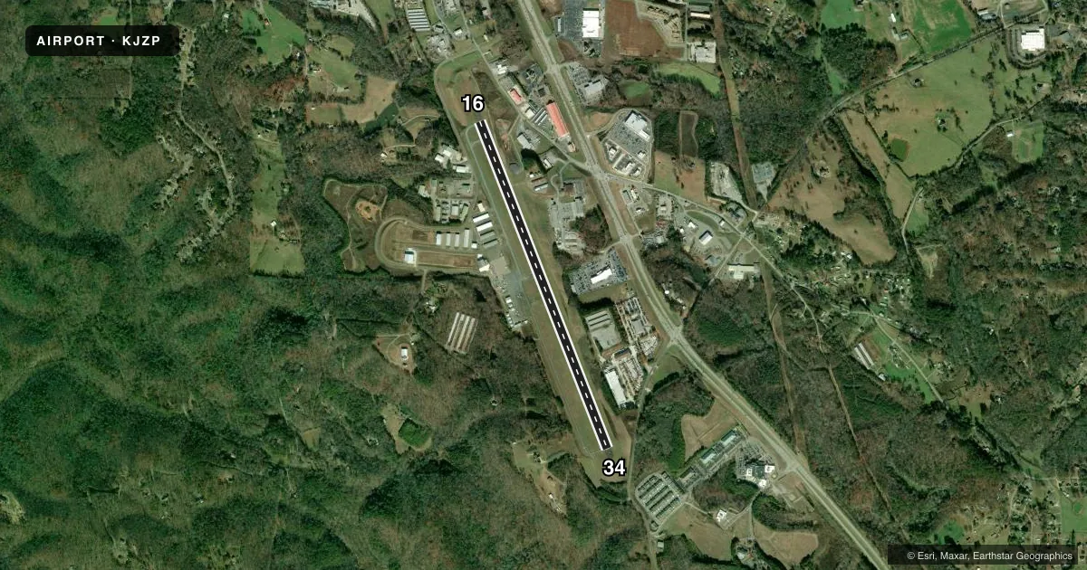
Airport sketch
Runways drawn to scale from FAA survey coordinates, rendered over satellite imagery. Not for navigation.
Approaches & charts
Services on the field
Fuel grades, oxygen, maintenance, ramp storage and lighting — as declared to the FAA by the airport operator.
Fuel & services
- Fuel
- 100LLA+
- Oxygen (bottled)
- Not available
- Oxygen (bulk)
- Not available
- Airframe repair
- Major
- Power plant repair
- Minor
- Other services
- AVNCS,INSTR
Ramp & ground
- Transient storage
- Tie-down
- Landing fee
- No fee published
- Lighting schedule
- SEE RMK
- Beacon schedule
- SS-SR
- Beacon
- White / Green (civil land)(WG)
- Wind indicator
- Lighted
- Segmented circle
- Yes
Fuel & FBOs
Cheapest 100LL and Jet A on the field and nearby. Always confirm with the FBO before taxi.
Airport notes
Surface conditions, obstructions, local procedures, lighting outages and other notes published with each FAA cycle.
General notes
- DEER & WILDLIFE ON & INVOF ARPT.
- FOR CD CTC ATLANTA ARTCC AT 770-210-7692.
Lighting notes
- REIL RWY 16 & 34; PAPI RWY 16 & 34; MIRL RWY 16/34 - OPR CONSLY.
Approach & departure obstructions
- 16PAPI UNUSBL BYD 4 DEG LEFT OF CNTRLN.
VFR map & nearby airports
VFR sectional. Tap any ICAO chip to open that airport.
Key facts · KJZP
Answer card- ICAO
- KJZP
- Name
- PICKENS COUNTY
- Location
- JASPER, GEORGIA
- Elevation
- 1,535.1 ft MSL
- Traffic pattern altitude
- 2,535.1 ft MSL (1,000 AGL)
- Control tower
- Non-towered (use CTAF)
- Total runways
- 1
- Longest runway
- 16/34 · 5,000 ft
- Published ILS approaches
- 0
- Published frequencies
- 2
- Magnetic variation
- 4°
- Current flight rules
- VFR
- Current wind
- 000° at 0 kt
- Favored runway now
- –
Pickens County Airport sits in Jasper, Georgia. The field elevation is 1,535.1 ft MSL. It has one runway. Runway 16/34 is 5,000 ft long with an asphalt surface. There is no control tower. CTAF and UNICOM are both 122.725.
No ILS approaches are published here. Pattern altitude is not published, so use the standard 1,000 ft AGL for light piston operations unless the current Chart Supplement says otherwise. The airport has PAPI on both runway ends. Medium intensity runway lights operate continuously. The PAPI on runway 16 is unusable beyond 4 degrees left of the centerline, so stay centered on final.
Pickens County Airport has one on-field FBO. Pickens County Airport carries 100LL and Jet A. Call (706) 253-8830 for current service details before you go. Deer and other wildlife are reported on and near the airport, so plan your taxi and landing roll with that in mind. For clearance delivery, contact Atlanta ARTCC at 770-210-7692. With no tower and no published ILS, this is a straightforward non-towered field, but it still deserves a careful look at the current Chart Supplement before departure.