METAR & TAF 49A
Current METAR
Observed 06:15Z
K49A 270615Z AUTO 36003KT 5SM BR CLR 23/23 A2997 RMK AO2
- Wind
- 360° @ 3 kt
- Visibility
- 5 SM
- Temp / Dew
- 23°C / 23°C
- Altimeter
- 29.97 inHg
- Clouds
- CLR
- Density alt
- 2,740 ft
- Ceiling
- Unlimited
- Rules
- MVFR
Airport info & contacts
Manager on record, flight service, ARTCC, attendance schedule and pattern altitude — published by the FAA and refreshed every 28 days.
Location
- From city
- 4 NM S
- VFR sectional
- ATLANTA
- ARTCC
- ZTL · ATLANTA
- NOTAM facility
- MCN (NOTAM-D)
Airport manager
- Name
- RICHARD MILNER
- Phone
- 706-889-2255
- Address
- 455 SUNLIGHT ROAD, ELLIJAY GA 30540
Flight service · Hours
- FSS MCN
- MACON1-800-WX-BRIEF
- Attendance
- MON-SAT · 0800 - 1700
Frequencies
Tap any row to copy the frequency to your clipboard.
Runways & pattern
Full pagePattern entry · RWY 03
LEFT TRAFFICRunway end performance
| End | TORA | TODA | ASDA | LDA | VGSI | Approach lights | Obstruction |
|---|---|---|---|---|---|---|---|
| 03 | — | — | — | — | — | — | 41', trees, 282' from thr, 239' R of cntrln, slope 2 |
| 21 | — | — | — | — | — | — | 40', trees, 248' from thr, 244' R of cntrln, slope 1 |
Declared distances in feet. TORA = takeoff run available, TODA = takeoff distance, ASDA = accelerate-stop, LDA = landing distance.
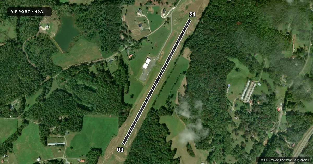
Airport sketch
Runways drawn to scale from FAA survey coordinates, rendered over satellite imagery. Not for navigation.
Approaches & charts
Services on the field
Fuel grades, oxygen, maintenance, ramp storage and lighting — as declared to the FAA by the airport operator.
Fuel & services
- Fuel
- 100LL
- Oxygen (bottled)
- Not available
- Oxygen (bulk)
- Not available
- Airframe repair
- Not available
- Power plant repair
- Not available
Ramp & ground
- Transient storage
- Tie-down
- Landing fee
- No fee published
- Customs
- Not available
- Lighting schedule
- SEE RMK
- Beacon schedule
- SS-SR
- Beacon
- White / Green (civil land)(WG)
- Wind indicator
- Lighted
- Segmented circle
- Yes
Fuel & FBOs
Cheapest 100LL and Jet A on the field and nearby. Always confirm with the FBO before taxi.
Airport notes
Surface conditions, obstructions, local procedures, lighting outages and other notes published with each FAA cycle.
General notes
- FOR CD CTC ATLANTA ARTCC AT 770-210-7692.
- RWY IS USED TO BACK TAXI, ACFT MUST CLEAR THE RWY TO TWY BEFORE ADDNL ACFT CAN LAND.
- WILDLIFE IN AND AROUND THE ARPT.
Lighting notes
- ACTVT RWY 03/21 MIRL - CTAF.
Fuel notes
- 100LL24 HR CREDIT CARD SVC AVBL.
VFR map & nearby airports
VFR sectional. Tap any ICAO chip to open that airport.
Key facts · 49A
Answer card- ICAO
- 49A
- Name
- GILMER COUNTY
- Location
- ELLIJAY, GEORGIA
- Elevation
- 1,485.5 ft MSL
- Traffic pattern altitude
- 2,485.5 ft MSL (1,000 AGL)
- Control tower
- Non-towered (use CTAF)
- Total runways
- 1
- Longest runway
- 03/21 · 3,507 ft
- Published ILS approaches
- 0
- Published frequencies
- 2
- Magnetic variation
- 5°
- Current flight rules
- MVFR
- Current wind
- 360° at 3 kt
- Favored runway now
- RWY 03
Gilmer County Airport (49A) sits in Ellijay, Georgia. The field elevation is 1,485.5 ft MSL. It has one runway, 03/21, which is 3,507 ft long and asphalt. There is no control tower. CTAF and UNICOM are both 123.0. No ILS approaches are published here.
Pattern altitude is not published. Use 1,000 ft AGL for light piston traffic unless the current Chart Supplement says otherwise. That puts the pattern at about 2,485.5 ft MSL based on the listed field elevation. The airport uses magnetic runway headings. Runway 03 is about 030° magnetic. Runway 21 is about 210° magnetic.
Gilmer County Airport has one on-field FBO. Gilmer County Airport carries 100LL. Twenty-four hour credit card service is available for 100LL fuel. The published remarks also note medium intensity runway lights on 03/21 that are activated by CTAF. The runway is used for back taxiing. Aircraft must clear the runway to the taxiway before another aircraft can land. Wildlife is also reported in and around the airport, so keep a sharp scan on arrival and departure.
For a first-time visit, plan for an uncontrolled field with a single short runway and no published instrument approach. If you need clearance delivery, contact Atlanta ARTCC at the number listed in the Chart Supplement. Check the current Chart Supplement for any noise or curfew restrictions before flying into the field.