METAR & TAF 9A0
9A0 does not publish a METAR.
Showing the nearest reporting station: KDZJ (BLAIRSVILLE) · 16.3 NM away. Conditions at 9A0 may differ.
METAR · KDZJ
Observed 18:15Z
KDZJ 261815Z AUTO 32007KT 230V350 10SM SCT033 SCT043 BKN050 29/22 A3004 RMK AO2 T02930223
- Wind
- 320° @ 7 kt
- Visibility
- 10 SM
- Temp / Dew
- 29°C / 22°C
- Altimeter
- 30.04 inHg
- Clouds
- BKN
- Density alt
- 3,179 ft
- Ceiling
- 5,000 ft AGL
- Rules
- VFR
Airport info & contacts
Manager on record, flight service, ARTCC, attendance schedule and pattern altitude — published by the FAA and refreshed every 28 days.
Location
- From city
- 3 NM NW
- VFR sectional
- ATLANTA
- ARTCC
- ZTL · ATLANTA
- NOTAM facility
- MCN (NOTAM-D)
Airport manager
- Name
- DAVID CAMPBELL
- Phone
- 706-974-1020
- Address
- 99 COURTHOUSE HILL, SUITE H, DAHLONEGA GA 30533
Flight service · Hours
- FSS MCN
- MACON1-800-WX-BRIEF
- Attendance
- Unattended
Frequencies
Tap any row to copy the frequency to your clipboard.
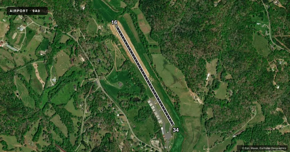
Runways & pattern
Full pagePattern entry · RWY 34
LEFT TRAFFICRunway end performance
| End | TORA | TODA | ASDA | LDA | VGSI | Approach lights | Obstruction |
|---|---|---|---|---|---|---|---|
| 16 | — | — | — | — | — | — | 163', trees, 1280' from thr, 231' R of cntrln, slope 6 |
| 34 | — | — | — | — | — | — | 158', trees, 1535' from thr, 236' R of cntrln, slope 8 |
Declared distances in feet. TORA = takeoff run available, TODA = takeoff distance, ASDA = accelerate-stop, LDA = landing distance.
Airport sketch
Runways drawn to scale from FAA survey coordinates, rendered over satellite imagery. Not for navigation.
Approaches & charts
Services on the field
Fuel grades, oxygen, maintenance, ramp storage and lighting — as declared to the FAA by the airport operator.
Fuel & services
- Fuel
- 100LL
- Oxygen (bottled)
- Not available
- Oxygen (bulk)
- Not available
- Airframe repair
- Not available
- Power plant repair
- Not available
Ramp & ground
- Transient storage
- Tie-down
- Landing fee
- No fee published
- Customs
- Not available
- Wind indicator
- Yes
- Segmented circle
- No
Fuel & FBOs
Cheapest 100LL and Jet A on the field and nearby. Always confirm with the FBO before taxi.
Airport notes
Surface conditions, obstructions, local procedures, lighting outages and other notes published with each FAA cycle.
General notes
- ARPT CLSD TO ACFT AT NGT, DAYTIME USE ONLY.
- DEER & WILDLIFE ON OR INVOF ARPT.
- FOR CD CTC ATLANTA ARTCC AT 770-210-7692.
Fuel notes
- 100LL24 HR SELF SERVE WITH CREDIT CARD.
Approach & departure obstructions
- 1615:1 APCH SLP TO DSPLCD THR, TREES 2469 FT OUT & 120 FT LEFT.
- 34APCH SLP 25:1 TO DSPLCD THR, TREELINE 2325 FT FROM DSPLCD THR.
Other notes
- EXISTED PRIOR TO 1959.
- MANAGERARPT ADDRESS: 1682 CAMP WAHSEGA RD.
VFR map & nearby airports
VFR sectional. Tap any ICAO chip to open that airport.
Key facts · 9A0
Answer card- ICAO
- 9A0
- Name
- LUMPKIN COUNTY-WIMPYS
- Location
- DAHLONEGA, GEORGIA
- Elevation
- 1,329 ft MSL
- Traffic pattern altitude
- 2,329 ft MSL (1,000 AGL)
- Control tower
- Non-towered (use CTAF)
- Total runways
- 1
- Longest runway
- 16/34 · 3,024 ft
- Published ILS approaches
- 0
- Published frequencies
- 1
- Magnetic variation
- 3°
- Current flight rules
- VFR
- Current wind
- 320° at 7 kt
- Favored runway now
- RWY 34
Lumpkin County-Wimpy's Airport (9A0) sits in Dahlonega, Georgia. Field elevation is 1,329 ft MSL. The airport has one runway, 16/34, which is 3,024 ft long and asphalt. There is no control tower. CTAF is 122.9. No ILS approaches are published here.
Pattern altitude is not published. Use the standard 1,000 ft AGL unless the current Chart Supplement says otherwise. That puts the light-piston pattern at about 2,329 ft MSL. The field is for daytime use only. It is closed to aircraft at night. Deer and other wildlife are reported on or near the airport. Keep a sharp scan on taxi, takeoff and landing.
On the field, Lumpkin County-Wimpy's Airport is listed as the FBO. Fuel grades are not reported in the facts block. The published remarks also note 24-hour self-serve 100LL with credit card. For clearance delivery, contact Atlanta ARTCC at 770-210-7692. Runway 16 has a displaced-threshold approach with trees close in the approach path. Runway 34 also has a treeline near the approach area. If you are planning a night arrival, do not count on it here. Check the current Chart Supplement and call the airport operator or the FBO directly before you go.