METAR & TAF KAJR
Current METAR
Observed 09:55Z
KAJR 270955Z AUTO 00000KT 7SM CLR 22/21 A2991 RMK AO2 T02240212
- Wind
- 000° @ 0 kt
- Visibility
- 7 SM
- Temp / Dew
- 22°C / 21°C
- Altimeter
- 29.91 inHg
- Clouds
- CLR
- Density alt
- 2,648 ft
- Ceiling
- Unlimited
- Rules
- VFR
Airport info & contacts
Manager on record, flight service, ARTCC, attendance schedule and pattern altitude — published by the FAA and refreshed every 28 days.
Location
- From city
- 2 NM SW
- VFR sectional
- ATLANTA
- ARTCC
- ZTL · ATLANTA
- NOTAM facility
- MCN (NOTAM-D)
Airport manager
- Name
- BILL HARDEN
- Phone
- 706-839-0247
- Address
- 1112 AIRPORT ROAD, CORNELIA GA 30531
Flight service · Hours
- FSS MCN
- MACON1-800-WX-BRIEF
- Attendance
- 0800-1800
Frequencies
Tap any row to copy the frequency to your clipboard.
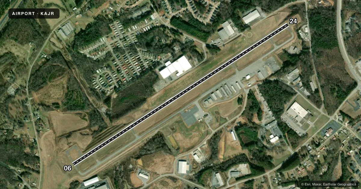
Runways & pattern
Full pagePattern entry · RWY 06
LEFT TRAFFICRunway end performance
| End | TORA | TODA | ASDA | LDA | VGSI | Approach lights | Obstruction |
|---|---|---|---|---|---|---|---|
| 06 | 5,503' | 5,503' | 5,503' | 4,111' | PAPI 4-box left(3°) | — | 58', trees, 664' from thr, 307' R of cntrln, slope 8 |
| 24 | 5,503' | 5,503' | 5,503' | 5,503' | PAPI 4-box left(3°) | — | 23', trees, 453' from thr, 163' R of cntrln, slope 11 |
Declared distances in feet. TORA = takeoff run available, TODA = takeoff distance, ASDA = accelerate-stop, LDA = landing distance.
Airport sketch
Runways drawn to scale from FAA survey coordinates, rendered over satellite imagery. Not for navigation.
Approaches & charts
Services on the field
Fuel grades, oxygen, maintenance, ramp storage and lighting — as declared to the FAA by the airport operator.
Fuel & services
- Fuel
- 100LLA+
- Oxygen (bottled)
- Not available
- Oxygen (bulk)
- Not available
- Airframe repair
- Major
- Power plant repair
- Major
- Other services
- INSTR,RNTL
Ramp & ground
- Transient storage
- Tie-down
- Landing fee
- No fee published
- Customs
- Not available
- Lighting schedule
- SEE RMK
- Beacon schedule
- SS-SR
- Beacon
- White / Green (civil land)(WG)
- Wind indicator
- Lighted
- Segmented circle
- Yes
Fuel & FBOs
Cheapest 100LL and Jet A on the field and nearby. Always confirm with the FBO before taxi.
Airport notes
Surface conditions, obstructions, local procedures, lighting outages and other notes published with each FAA cycle.
General notes
- DEER & WILDLIFE ON OR INVOF ARPT.
- FOR CD CTC ATLANTA ARTCC AT 770-210-7692.
- TWY A BTN TWY D AND TWY C CLSD TO ACFT WINGSPAN MORE THAN 80 FT.
Lighting notes
- MIRL RWY 06/24 PRESET ON LOW INTST DUSK-2200; TO INCR INTST - CTAF. AFT 2200 ACTVT - CTAF.
Approach & departure obstructions
- 06APCH RATIO 26:1 TO DSPLCD THR.
Other notes
- MANAGERARPT PHONE NUMBER - (706) 778-0198.
VFR map & nearby airports
VFR sectional. Tap any ICAO chip to open that airport.
Key facts · KAJR
Answer card- ICAO
- KAJR
- Name
- HABERSHAM COUNTY
- Location
- CORNELIA, GEORGIA
- Elevation
- 1,447.9 ft MSL
- Traffic pattern altitude
- 2,447.9 ft MSL (1,000 AGL)
- Control tower
- Non-towered (use CTAF)
- Total runways
- 1
- Longest runway
- 06/24 · 5,503 ft
- Published ILS approaches
- 0
- Published frequencies
- 2
- Magnetic variation
- 6°
- Current flight rules
- VFR
- Current wind
- 000° at 0 kt
- Favored runway now
- –
Habersham County Airport sits in Cornelia, Georgia. Field elevation is 1,447.9 ft MSL. The airport has one runway. Runway 06/24 is 5,503 ft long and asphalt. There is no control tower. CTAF and UNICOM are both 122.7. No ILS approaches are published here.
Pattern altitude is not published. Use the standard 1,000 ft AGL for light piston traffic unless the current Chart Supplement says otherwise. The on-field FBO is Habersham County Airport. It carries 100LL and Jet A. Call (706) 839-0247 for current service details.
A few operational notes matter here. Runway lights on 06/24 are preset low from dusk to 2200. Use CTAF to increase intensity. After 2200, activate the lights via CTAF. The published remarks also note deer and wildlife in the area. Taxiway A between taxiway D and taxiway C is closed to aircraft with wingspan more than 80 feet. There is also a published obstruction note for the runway 06 approach path. If you are planning a clearance, contact Atlanta ARTCC at 770-210-7692. For the latest airport status, check the current FAA Chart Supplement or call the airport operator at (706) 778-0198.