METAR & TAF 18A
Current METAR
Observed 13:35Z
K18A 271335Z AUTO 27004KT 10SM CLR 27/23 A2991 RMK AO2 T02650234
- Wind
- 270° @ 4 kt
- Visibility
- 10 SM
- Temp / Dew
- 27°C / 23°C
- Altimeter
- 29.91 inHg
- Clouds
- CLR
- Density alt
- 2,556 ft
- Ceiling
- Unlimited
- Rules
- VFR
Airport info & contacts
Manager on record, flight service, ARTCC, attendance schedule and pattern altitude — published by the FAA and refreshed every 28 days.
Location
- From city
- 1 NM SW
- VFR sectional
- ATLANTA
- ARTCC
- ZTL · ATLANTA
- NOTAM facility
- MCN (NOTAM-D)
Airport manager
- Name
- CHUCK FLOYD
- Phone
- 321-514-9571
- Address
- 823 AIRPORT ROAD, CANON GA 30520
Flight service · Hours
- FSS MCN
- MACON1-800-WX-BRIEF
- Attendance
- Unattended
Frequencies
Tap any row to copy the frequency to your clipboard.
Runways & pattern
Full pagePattern entry · RWY 26
LEFT TRAFFICRunway end performance
| End | TORA | TODA | ASDA | LDA | VGSI | Approach lights | Obstruction |
|---|---|---|---|---|---|---|---|
| 08 | — | — | — | — | PAPI 2-box left(3°) | — | 42', trees, 578' from thr, 294' R of cntrln, slope 9 |
| 26 | — | — | — | — | PAPI 2-box left(3°) | — | 84', trees, 1796' from thr, 351' R of cntrln, slope 19 |
Declared distances in feet. TORA = takeoff run available, TODA = takeoff distance, ASDA = accelerate-stop, LDA = landing distance.
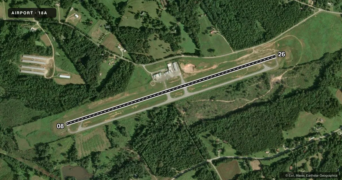
Airport sketch
Runways drawn to scale from FAA survey coordinates, rendered over satellite imagery. Not for navigation.
Approaches & charts
Services on the field
Fuel grades, oxygen, maintenance, ramp storage and lighting — as declared to the FAA by the airport operator.
Fuel & services
- Fuel
- 100LLA
- Oxygen (bottled)
- Not available
- Oxygen (bulk)
- Not available
- Airframe repair
- Not available
- Power plant repair
- Not available
- Other services
- INSTR
Ramp & ground
- Transient storage
- Tie-down
- Landing fee
- No fee published
- Customs
- Not available
- Lighting schedule
- SEE RMK
- Beacon schedule
- SS-SR
- Beacon
- White / Green (civil land)(WG)
- Wind indicator
- Lighted
- Segmented circle
- Yes
Fuel & FBOs
Cheapest 100LL and Jet A on the field and nearby. Always confirm with the FBO before taxi.
Airport notes
Surface conditions, obstructions, local procedures, lighting outages and other notes published with each FAA cycle.
General notes
- FOR CD CTC ATLANTA ARTCC AT 770-210-7692.
Lighting notes
- DUSK-0000. AFT 0000, ACTVT PAPI RWY 08 & 26; MIRL RWY 08/26 - CTAF.
Fuel notes
- 100LLSELF SVC 100LL AND A FUEL AVBL 24 HRS WITH CREDIT CARD.
Other notes
- MANAGERAIRPORT AUTHORITY.
- OWNERFRANKLIN-HART AIRPORT AUTHORITY.
- MANAGERARPT PHONE 706-245-1002.
VFR map & nearby airports
VFR sectional. Tap any ICAO chip to open that airport.
Key facts · 18A
Answer card- ICAO
- 18A
- Name
- FRANKLIN-HART
- Location
- CANON, GEORGIA
- Elevation
- 889.9 ft MSL
- Traffic pattern altitude
- 1,889.9 ft MSL (1,000 AGL)
- Control tower
- Non-towered (use CTAF)
- Total runways
- 1
- Longest runway
- 08/26 · 5,000 ft
- Published ILS approaches
- 0
- Published frequencies
- 1
- Magnetic variation
- 5°
- Current flight rules
- VFR
- Current wind
- 270° at 4 kt
- Favored runway now
- RWY 26
Franklin-Hart Airport sits in Canon, Georgia. Field elevation is 889.9 ft MSL. It has one runway, 08/26, at 5,000 ft asphalt. There is no control tower. CTAF is 122.9. No ILS approaches are published here.
Pattern altitude is not published. Use 1,000 ft AGL as the standard light-piston pattern unless the current FAA Chart Supplement says otherwise. That puts the pattern near 1,890 ft MSL based on the field elevation. Runway headings are 72° and 252° magnetic. The airport is small and straightforward, so the main job is staying sharp on CTAF and checking the runway lighting plan before a late arrival.
Published remarks say the lights are on from dusk to 0000. After 0000, the PAPI on 08 and 26 plus the medium intensity runway lights on 08 and 26 can be activated by CTAF. Self-serve 100LL is available 24 hours with credit card. Franklin-Hart Airport also carries JET A. The on-field FBO is Franklin-Hart Airport. For clearance delivery, contact Atlanta ARTCC. First-time visitors should verify any current airport notes in the FAA Chart Supplement before departure, especially if planning a night arrival.