METAR & TAF KTOC
Current METAR
Observed 03:55Z
KTOC 270355Z AUTO 32004KT 10SM CLR 26/22 A2996 RMK AO2
- Wind
- 320° @ 4 kt
- Visibility
- 10 SM
- Temp / Dew
- 26°C / 22°C
- Altimeter
- 29.96 inHg
- Clouds
- CLR
- Density alt
- 2,505 ft
- Ceiling
- Unlimited
- Rules
- VFR
Airport info & contacts
Manager on record, flight service, ARTCC, attendance schedule and pattern altitude — published by the FAA and refreshed every 28 days.
Location
- From city
- 2 NM NE
- VFR sectional
- ATLANTA
- ARTCC
- ZTL · ATLANTA
- NOTAM facility
- MCN (NOTAM-D)
Airport manager
- Name
- AMBER MCCALL
- Phone
- 706-886-5632
- Address
- PO BOX 494, TOCCOA GA 30577
Flight service · Hours
- FSS MCN
- MACON1-800-WX-BRIEF
- Attendance
- MON-SAT · 0900-1800
- SUN · 1200-1800
Frequencies
Tap any row to copy the frequency to your clipboard.
Runways & pattern
Full pagePattern entry · RWY 27
LEFT TRAFFIC| Runway | Heading (°M) | Length | Surface | Traffic |
|---|---|---|---|---|
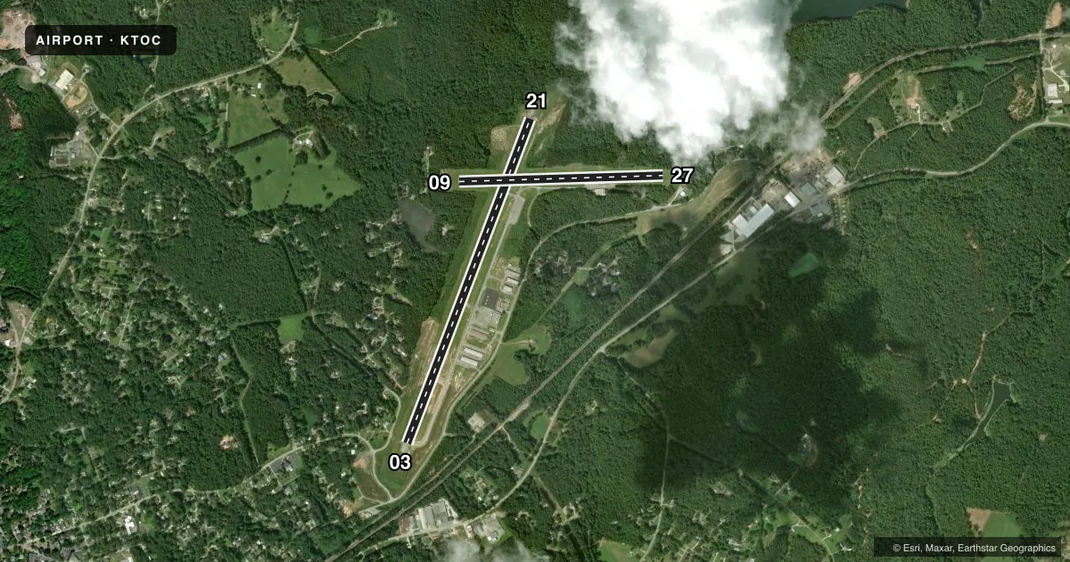
| 03/21 | 15° / 195° | 5,008 ft | ASPH | Standard L |
| 09/27Favored | 82° / 262° | 2,951 ft | ASPH | Standard L |
Runway end performance
| End | TORA | TODA | ASDA | LDA | VGSI | Approach lights | Obstruction |
|---|---|---|---|---|---|---|---|
| 03 | — | — | — | — | PAPI 2-box left(3.25°) | — | 51', trees, 1271' from thr, 343' R of cntrln, slope 21 |
| 21 | — | — | — | — | PAPI 2-box left(3°) | — | 18', trees, 218' from thr, 247' R of cntrln, slope 1 |
| 09 | — | — | — | — | — | — | 18', trees, 296' from thr, 134' R of cntrln, slope 5 |
| 27 | — | — | — | — | — | — | 38', trees, 211' from thr, 110' R of cntrln, slope 0 |
Declared distances in feet. TORA = takeoff run available, TODA = takeoff distance, ASDA = accelerate-stop, LDA = landing distance.
Airport sketch
Runways drawn to scale from FAA survey coordinates, rendered over satellite imagery. Not for navigation.
Approaches & charts
Services on the field
Fuel grades, oxygen, maintenance, ramp storage and lighting — as declared to the FAA by the airport operator.
Fuel & services
- Fuel
- 100LLA+
- Oxygen (bottled)
- Not available
- Oxygen (bulk)
- Not available
- Airframe repair
- Major
- Power plant repair
- Major
- Other services
- INSTR,RNTL
Ramp & ground
- Transient storage
- Tie-down
- Landing fee
- No fee published
- Customs
- Not available
- Lighting schedule
- SEE RMK
- Beacon schedule
- SS-SR
- Beacon
- White / Green (civil land)(WG)
- Wind indicator
- Lighted
- Segmented circle
- Yes
Fuel & FBOs
Cheapest 100LL and Jet A on the field and nearby. Always confirm with the FBO before taxi.
Airport notes
Surface conditions, obstructions, local procedures, lighting outages and other notes published with each FAA cycle.
General notes
- DEER ON OR INVOF ARPT
- FOR CD CTC ATLANTA ARTCC AT 770-210-7692.
Lighting notes
- DUSK-2200. AFTER 2200 ACTVT MIRL RY 03/21, REIL RYS 03 & 21, PAPI RYS 03 & 21 - CTAF.
Approach & departure obstructions
- 09CONTROLLING OBSTRUCTION EXCEEDS A 45 DEGREE SLOPE
VFR map & nearby airports
VFR sectional. Tap any ICAO chip to open that airport.
Key facts · KTOC
Answer card- ICAO
- KTOC
- Name
- TOCCOA RG LETOURNEAU FLD
- Location
- TOCCOA, GEORGIA
- Elevation
- 996 ft MSL
- Traffic pattern altitude
- 1,996 ft MSL (1,000 AGL)
- Control tower
- Non-towered (use CTAF)
- Total runways
- 2
- Longest runway
- 03/21 · 5,008 ft
- Published ILS approaches
- 0
- Published frequencies
- 2
- Magnetic variation
- 6°
- Current flight rules
- VFR
- Current wind
- 320° at 4 kt
- Favored runway now
- RWY 27
KTOC is in Toccoa, Georgia. The field elevation is 996 ft MSL. It has two asphalt runways. The longest is 03/21 at 5,008 ft. There is no control tower. CTAF and UNICOM are both 122.8.
No ILS approaches are published here. The pattern altitude is not published. Use the standard 1,000 ft AGL for light piston traffic unless the current Chart Supplement says otherwise. That puts the pattern at 1,996 ft MSL based on the listed field elevation.
Toccoa Aviation is on the field. It carries 100LL, Jet A and Jet A Prist. Deer are reported on or near the airport. Keep an eye out on taxi, takeoff and landing. Lighting is available from dusk to 2200. After 2200, runway 03/21 lighting can be activated by CTAF. The remarks also note a controlling obstruction off runway 09 that exceeds a 45 degree slope. That makes the 09 end worth a close look on departure and arrival. For clearance delivery, contact Atlanta ARTCC at 770-210-7692 before departure if you need it.