METAR & TAF KAND
Current METAR
Observed 12:56Z
KAND 271256Z AUTO 27003KT 10SM FEW120 26/24 A2989 RMK AO2 SLP111 T02610239
- Wind
- 270° @ 3 kt
- Visibility
- 10 SM
- Temp / Dew
- 26°C / 24°C
- Altimeter
- 29.89 inHg
- Clouds
- FEW
- Density alt
- 2,327 ft
- Ceiling
- Unlimited
- Rules
- VFR
Airport info & contacts
Manager on record, flight service, ARTCC, attendance schedule and pattern altitude — published by the FAA and refreshed every 28 days.
Location
- From city
- 3 NM SW
- VFR sectional
- ATLANTA
- ARTCC
- ZTL · ATLANTA
- NOTAM facility
- AND (NOTAM-D)
Airport manager
- Name
- BRETT GARRISON
- Phone
- 864-260-4163
- Address
- 5805 AIRPORT RD., ANDERSON SC 29626
Flight service · Hours
- FSS AND
- ANDERSON1-800-WX-BRIEF
- Attendance
- 0730-1930
Frequencies
Tap any row to copy the frequency to your clipboard.
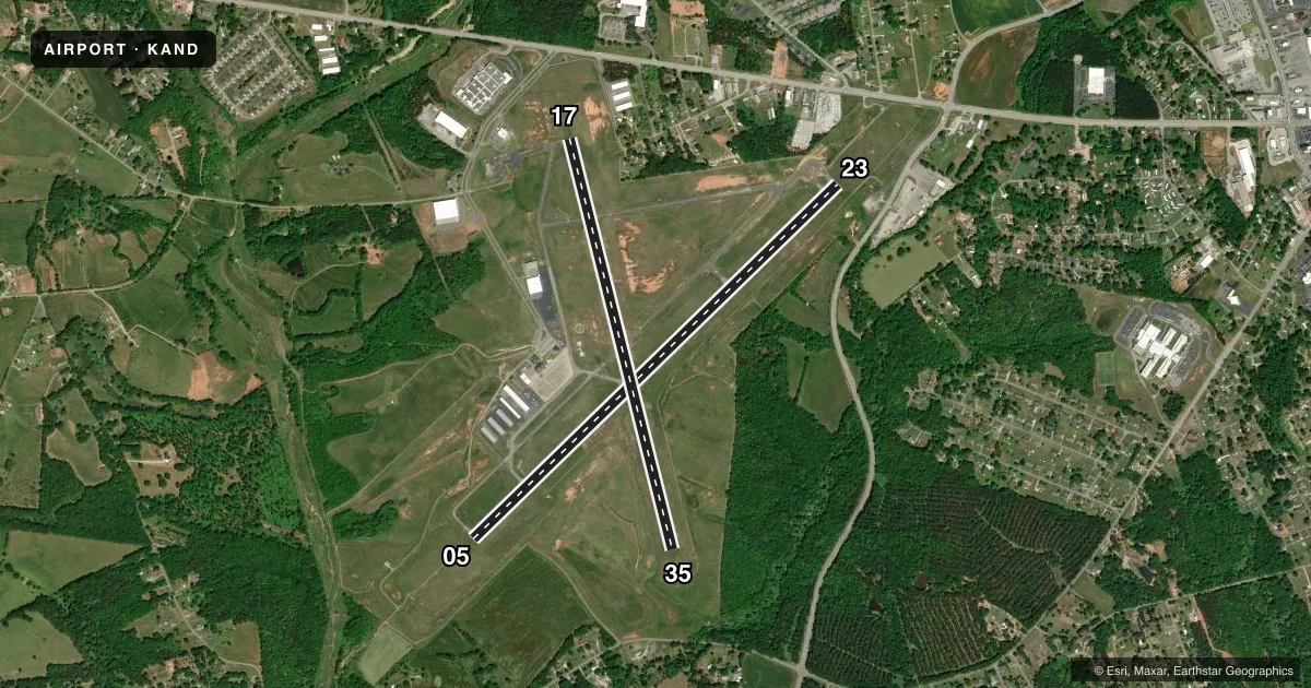
Runways & pattern
Full pagePattern entry · RWY 23
LEFT TRAFFIC| Runway | Heading (°M) | Length | Surface | Traffic |
|---|---|---|---|---|
| 05/23Favored | 41° / 221° | 6,002 ft | ASPH | Standard L |
| 17/35 | 161° / 341° | 4,996 ft | ASPH | Standard L |
Runway end performance
| End | TORA | TODA | ASDA | LDA | VGSI | Approach lights | Obstruction |
|---|---|---|---|---|---|---|---|
| 05 | — | — | — | — | PAPI 4-box left(3°) | MALSR | 66', trees, 1692' from thr, 577' R of cntrln, slope 22 |
| 23 | — | — | — | — | PAPI 4-box left(3°) | — | 80', trees, 1254' from thr, 461' R of cntrln, slope 13 |
| 17 | — | — | — | — | — | — | 42', trees, 1421' from thr, 162' R of cntrln, slope 29 |
| 35 | — | — | — | — | — | — | 56', trees, 1058' from thr, 11' R of cntrln, slope 15 |
Declared distances in feet. TORA = takeoff run available, TODA = takeoff distance, ASDA = accelerate-stop, LDA = landing distance.
Airport sketch
Runways drawn to scale from FAA survey coordinates, rendered over satellite imagery. Not for navigation.
Approaches & charts
ILS · 1
Services on the field
Fuel grades, oxygen, maintenance, ramp storage and lighting — as declared to the FAA by the airport operator.
Fuel & services
- Fuel
- 100LLA
- Oxygen (bottled)
- Low pressure
- Airframe repair
- Major
- Power plant repair
- Major
- Other services
- AFRT,AMB,CARGO,CHTR,INSTR,RNTL
Ramp & ground
- Transient storage
- Tie-down
- Hangar
- Landing fee
- Yes
- Customs
- Not available
- Lighting schedule
- SEE RMK
- Beacon schedule
- SS-SR
- Beacon
- White / Green (civil land)(WG)
- Wind indicator
- Lighted
- Segmented circle
- Yes
Fuel & FBOs
Cheapest 100LL and Jet A on the field and nearby. Always confirm with the FBO before taxi.
Airport notes
Surface conditions, obstructions, local procedures, lighting outages and other notes published with each FAA cycle.
General notes
- HEL WITH SKIDS ARE RSTRD TO LAND ON HELIPADS OR GRASSED AREAS.
- PROFILE OF RWY 05/23 RESTRICTS VIS FROM THLD RWY 05 TO THLD RWY 23.
- WILDLIFE ON & INVOF ARPT; MORE ACTIVE AT DUSK & DAWN.
- AEROBATIC PRACTICE AREA ON & INVOF ARPT.
- FOR CD IF UNA TO CTC ON FSS FREQ, CTC GREER APCH AT 864-877-8275, WHEN APCH CLSD CTC ATLANTA ARTCC AT 770-210-7692.
- PILOTS CONDUCTING EFVS OPS; BE AWARE LED ALS IN USE RWY 05.
Lighting notes
- ACTVT MALSR RWY 05; HIRL RWY 05/23; PERIMETER LGTS HELIPADS H1 & H2 - CTAF. PAPI RWY 05 & 23 OPR CONSLY.
Fuel notes
- 100LLAFT HRS 100LL FUEL AVBL WITH CREDIT CARD.
Runway surface & condition
- 17/35PCR VALUE: 130/F/D/X/T
Other notes
- EXISTED PRIOR TO 1958.
- NO RAMP FEE FOR PISTON SNGLS.
- 1CALL 864-964-5656 FOR SVC.
- 1ARPT UNATNDD THANKSGIVING, CHRISTMAS, NEW YEARS DAY, AND EASTER.
- 17/35WIDESPREAD CRACKS.
VFR map & nearby airports
VFR sectional. Tap any ICAO chip to open that airport.
Key facts · KAND
Answer card- ICAO
- KAND
- Name
- ANDERSON RGNL
- Location
- ANDERSON, SOUTH CAROLINA
- Elevation
- 781.9 ft MSL
- Traffic pattern altitude
- 1,781.9 ft MSL (1,000 AGL)
- Control tower
- Non-towered (use CTAF)
- Total runways
- 2
- Longest runway
- 05/23 · 6,002 ft
- Published ILS approaches
- 1
- Published frequencies
- 3
- Magnetic variation
- 5°
- Current flight rules
- VFR
- Current wind
- 270° at 3 kt
- Favored runway now
- RWY 23
Anderson Rgnl sits in Anderson, South Carolina. Field elevation is 781.9 ft MSL. The airport has two asphalt runways. The longest is runway 05/23 at 6,002 ft. There is no control tower, so plan to work CTAF 123.6 and coordinate carefully in the pattern. The published pattern altitude is not listed. Use 1,000 ft AGL for light piston traffic unless the current Chart Supplement says otherwise. That puts the normal pattern at about 1,782 ft MSL here.
Runway 05 has an ILS and MALSR lighting. High intensity runway lights are on 05/23. PAPI is published on both ends of 05/23 and runs continuously. The on-field FBO is Anderson Regional Airport. It carries 100LL and Jet A Prist. After hours, 100LL is available with credit card. The airport remarks also note wildlife near the field, with more activity at dawn and dusk. Runway 05/23 has a profile that limits visibility from the 05 threshold to the 23 threshold. Runway 17/35 has widespread cracks.
For a first-time arrival, the main things are the non-towered flow, the runway 05 ILS setup and the local surface and wildlife issues. Helicopters with skids are restricted to helipads or grassed areas. If you need clearance delivery help, use Greer Approach when available. If approach is closed, contact Atlanta ARTCC.