METAR & TAF KGYH
Current METAR
Observed 12:05Z
KGYH 271205Z 27006KT 10SM CLR 25/23 A2990
- Wind
- 270° @ 6 kt
- Visibility
- 10 SM
- Temp / Dew
- 25°C / 23°C
- Altimeter
- 29.90 inHg
- Clouds
- CLR
- Density alt
- 2,410 ft
- Ceiling
- Unlimited
- Rules
- VFR
Airport info & contacts
Manager on record, flight service, ARTCC, attendance schedule and pattern altitude — published by the FAA and refreshed every 28 days.
Location
- From city
- 6 NM S
- VFR sectional
- ATLANTA
- Pattern altitude
- 800 ft AGL · 1,756 ft MSL
- ARTCC
- ZTL · ATLANTA
- NOTAM facility
- GYH (NOTAM-D)
Airport manager
- Name
- DANNY MOYD
- Phone
- 864-277-3152
- Address
- 2 EXCHANGE ST, GREENVILLE SC 29605
Flight service · Hours
- FSS AND
- ANDERSON1-800-WX-BRIEF
- Attendance
- 0600-1900
Frequencies
Tap any row to copy the frequency to your clipboard.
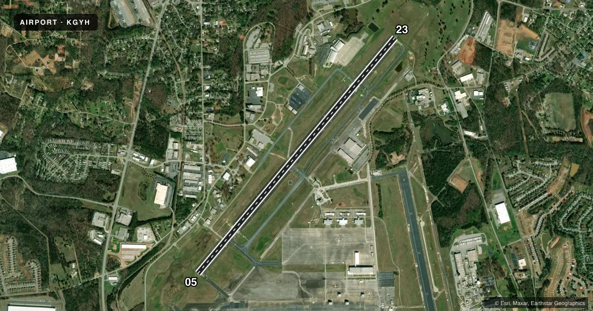
Runways & pattern
Full pagePattern entry · RWY 23
LEFT TRAFFICRunway end performance
| End | TORA | TODA | ASDA | LDA | VGSI | Approach lights | Obstruction |
|---|---|---|---|---|---|---|---|
| 05 | — | — | — | — | PAPI 4-box left(3.22°) | MALSR | — |
| 23 | — | — | — | — | PAPI 4-box left(4.14°) | — | 42', trees, 1600' from thr, 650' R of cntrln, slope 33 |
Declared distances in feet. TORA = takeoff run available, TODA = takeoff distance, ASDA = accelerate-stop, LDA = landing distance.
Airport sketch
Runways drawn to scale from FAA survey coordinates, rendered over satellite imagery. Not for navigation.
Approaches & charts
ILS · 1
Services on the field
Fuel grades, oxygen, maintenance, ramp storage and lighting — as declared to the FAA by the airport operator.
Fuel & services
- Fuel
- 100LLA
- Oxygen (bottled)
- Not available
- Oxygen (bulk)
- High pressure
- Airframe repair
- Major
- Power plant repair
- Major
- Other services
- CARGO,CHTR
Ramp & ground
- Transient storage
- Tie-down
- Hangar
- Landing fee
- No fee published
- Customs
- Not available
- Lighting schedule
- SEE RMK
- Beacon schedule
- SS-SR
- Beacon
- White / Green (civil land)(WG)
- Wind indicator
- Lighted
- Segmented circle
- Yes
Fuel & FBOs
Cheapest 100LL and Jet A on the field and nearby. Always confirm with the FBO before taxi.
Airport notes
Surface conditions, obstructions, local procedures, lighting outages and other notes published with each FAA cycle.
General notes
- LTD PRK, RAMP CLSD TO ALL TFC EXC MIL R/W ACFT WITH 24HR PPR. CTC ARNG OPS C803-299-5214. OPR 1230-2200Z++ MON-FRI, EXC HOL. LTD TRAN MAINT FOR CH47 AND UH72 ACFT ONLY.
- ARNG OPS PTD - 41.3 308.7 REMARKS: ARNG OPS C803-299-5214 (GREENVILLE OPS).
- TWY A CLSD TO WINGSPANS GTR THAN 79 FT WO PRIOR CDN WITH ARPT MGMT.
- SFC CONDS NOT RPRTD DAILY 9PM TO 7AM LOCAL.
Lighting notes
- ACTVT MALSR RWY 05; HIRL RWY 05/23 - CTAF.
Runway surface & condition
- 05/23PCR VALUE: 440/R/C/W/T
Arresting gear
- 05_BAK-14BAK-14 (1502 FT).
- 23_BAK-14BAK-14 (1703 FT).
Other notes
- EXISTED PRIOR TO 1958.
- CLSD TO ACR OPNS WITH MORE THAN 30 PSGR SEATS EXCP 24 HR PPR CALL AMGR 864-277-3152.
VFR map & nearby airports
VFR sectional. Tap any ICAO chip to open that airport.
Key facts · KGYH
Answer card- ICAO
- KGYH
- Name
- DONALDSON FLD
- Location
- GREENVILLE, SOUTH CAROLINA
- Elevation
- 955.9 ft MSL
- Traffic pattern altitude
- 1,755.9 ft MSL (800 AGL)
- Control tower
- Towered · 0700-2100
- Total runways
- 1
- Longest runway
- 05/23 · 8,000 ft
- Published ILS approaches
- 1
- Published frequencies
- 9
- Magnetic variation
- 7°
- Current flight rules
- VFR
- Current wind
- 270° at 6 kt
- Favored runway now
- RWY 23
Donaldson Fld sits in Greenville, South Carolina. Field elevation is 955.9 ft MSL. The airport has one runway, 05/23, which is 8,000 ft long and paved concrete. The tower is open from 0700 to 2100 local. The field has one ILS approach, published for runway 05. Pattern altitude is 1,800 ft AGL, which is 2,755.9 ft MSL.
This is a controlled field with published traffic and lighting details that matter on arrival. MALSR lighting is available for runway 05. High intensity runway lights are available for runways 05 and 23. They are controlled by CTAF. The airport also has published remarks that affect operations. Parking is limited. The ramp is closed to all traffic except military rotary-wing aircraft with 24-hour prior permission. Operations are listed from 1230 to 2200 Zulu Monday through Friday except holidays. Surface conditions are not reported daily from 9 PM to 7 AM local time.
On the field, Stevens Aerospace & Defense Systems carries JET_A_PRIST. Vantage Aviation carries AVGAS_100LL and JET_A_PRIST. First-time pilots should pay close attention to the published restrictions before planning a stop here. Taxiway A is closed to aircraft with wingspans greater than 79 feet without prior coordination. Runway 23 has a BAK-14 arresting device. Runway 05 has one too. Check the current FAA Chart Supplement and call the airport operator or FBO directly before arrival if your operation is anything out of the ordinary.