METAR & TAF KGMU
Current METAR
Observed 23:53Z
KGMU 262353Z 15005KT 10SM SCT044 SCT060 29/24 A2990 RMK AO2 SLP115 6//// T02890239 10306 20283 55001 $
- Wind
- 150° @ 5 kt
- Visibility
- 10 SM
- Temp / Dew
- 29°C / 24°C
- Altimeter
- 29.90 inHg
- Clouds
- SCT
- Density alt
- 3,004 ft
- Ceiling
- Unlimited
- Rules
- VFR
Airport info & contacts
Manager on record, flight service, ARTCC, attendance schedule and pattern altitude — published by the FAA and refreshed every 28 days.
Location
- From city
- 3 NM E
- VFR sectional
- ATLANTA
- Pattern altitude
- 800 ft AGL · 1,848 ft MSL
- ARTCC
- ZTL · ATLANTA
- NOTAM facility
- GMU (NOTAM-D)
Airport manager
- Name
- JAMES STEPHENS
- Phone
- 864-242-4777
- Address
- 100 TOWER DR, UNIT 2, GREENVILLE SC 29607
Flight service · Hours
- FSS AND
- ANDERSON1-800-WX-BRIEF
- Attendance
- SAT-SUN · 0700-1900
- MON-FRI · 0600-1900
Frequencies
Tap any row to copy the frequency to your clipboard.
Runways & pattern
Full pagePattern entry · RWY 19
RIGHT TRAFFIC| Runway | Heading (°M) | Length | Surface | Traffic |
|---|---|---|---|---|
| 01/19Favored | 356° / 176° | 5,393 ft | ASPH | 19 R |
| 10/28 | 86° / 266° | 4,000 ft | ASPH | 28 R |
Runway end performance
| End | TORA | TODA | ASDA | LDA | VGSI | Approach lights | Obstruction |
|---|---|---|---|---|---|---|---|
| 01 | — | — | — | — | PAPI 4-box left(3°) | MALSF | 35', tree, 1247' from thr, 293' R of cntrln, slope 29 |
| 19 | — | — | — | — | PAPI 4-box left(3.5°) | — | 117', tree, 2580' from thr, 406' R of cntrln, slope 20 |
| 10 | 3,998' | 3,998' | 3,728' | 3,463' | — | — | 36', tree, 707' from thr, 188' R of cntrln, slope 14 |
| 28 | 3,998' | 3,998' | 3,733' | 3,463' | PAPI 2-box left(3°) | — | 31', tree, 444' from thr, 110' R of cntrln, slope 7 |
Declared distances in feet. TORA = takeoff run available, TODA = takeoff distance, ASDA = accelerate-stop, LDA = landing distance.
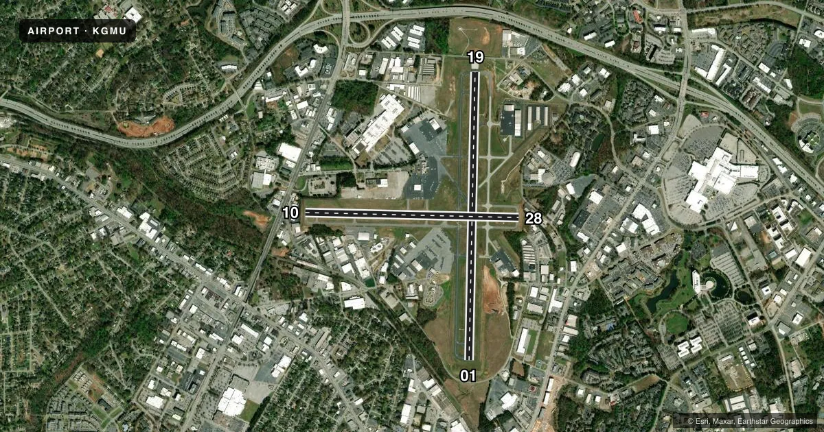
Airport sketch
Runways drawn to scale from FAA survey coordinates, rendered over satellite imagery. Not for navigation.
Approaches & charts
ILS · 1
Services on the field
Fuel grades, oxygen, maintenance, ramp storage and lighting — as declared to the FAA by the airport operator.
Fuel & services
- Fuel
- 100LLA
- Oxygen (bottled)
- HIGH/LOW
- Oxygen (bulk)
- HIGH/LOW
- Airframe repair
- Major
- Power plant repair
- Major
- Other services
- AMB,AVNCS,CARGO,CHTR,INSTR,RNTL,SALES,SURV
Ramp & ground
- Transient storage
- Tie-down
- Hangar
- Landing fee
- No fee published
- Customs
- Not available
- Lighting schedule
- SEE RMK
- Beacon schedule
- SS-SR
- Beacon
- White / Green (civil land)(WG)
- Wind indicator
- Lighted
- Segmented circle
- Yes
Fuel & FBOs
Cheapest 100LL and Jet A on the field and nearby. Always confirm with the FBO before taxi.
Airport notes
Surface conditions, obstructions, local procedures, lighting outages and other notes published with each FAA cycle.
General notes
- ACFT OPER IN THE GREENVILLE ARPT TFC AREA S THRU E BE ALERT FOR JET & CONVENTIONAL TFC DES ON THE GREENVILLE-SPARTANBURG LOC CRS.
- ACFT INBD FROM THE SSW OR ON ILS RWY 01 APCH BE ALERT FOR TFC 4.5 MI S OPERG IN THE DONALDSON FIELD ARPT TFC PAT AT 1800 FT OR BLW.
- NO OVNGT PRKG ON HELIPADS.
- NO ACFT PMTD ON TWYS 'C' OR 'D' WHEN ACFT GTR THAN 12500 LBS IS OPERG ON RWY 10/28.
- RWY 10/28 RSTRD TO SMALL ACFT (LESS THAN 12500 LBS) WHEN ACFT OPERG ON TWYS C OR D.
- VOLUNTARY NOISE ABATEMENT PROCS IN EFCT; REQ TO LMT OPS BTN 0200-1100Z, REQ RPTD PAT PRACTICE BE TAKEN TO ALT ARPTS.
Lighting notes
- ATC-CTL. WHEN ATCT CLSD ACTVT MALSF RWY 01; REIL RWY 19; HIRL RWY 01/19; PERIMETER LGTS H1, H2, AND TWY LGHTS - CTAF. REIL RWY 28; PAPI RWY 01, 19, 28; MIRL RWY 10/28 UNAVBL WHEN TWR CLSD.
Runway surface & condition
- 01/19ARRESTING GEAR/SYSTEM: ENGINEERED MATERIAL ARRESTING SYSTEM (EMAS) 157 FT IN LENGTH BY 113 FT IN WIDTH AT THE DEPARTURE END OF RWY 01.
Approach & departure obstructions
- 10MULT TREES 89 FT FROM RWY 10 PAVEMENT END.
- 10RWY 10 APCH IS 28:1 AT DSPLCD THLD.
- 28RWY 28 APCH IS 36:1 AT DSPLCD THLD.
Other notes
- ARPT EXISTED PRIOR TO 1959; HELIPADS ARE CONDITIONAL. SEE AIRSPACE LETTER DATED JAN 24, 1990 FOR CONDITIONS.
- TPA: 800 FT AGL FOR LGT ACFT, 1000 FT AGL FOR HVY ACFT.
VFR map & nearby airports
VFR sectional. Tap any ICAO chip to open that airport.
Key facts · KGMU
Answer card- ICAO
- KGMU
- Name
- GREENVILLE DOWNTOWN
- Location
- GREENVILLE, SOUTH CAROLINA
- Elevation
- 1,048 ft MSL
- Traffic pattern altitude
- 1,848 ft MSL (800 AGL)
- Control tower
- Towered · 0700-2200
- Total runways
- 2
- Longest runway
- 01/19 · 5,393 ft
- Published ILS approaches
- 1
- Published frequencies
- 8
- Magnetic variation
- 5°
- Current flight rules
- VFR
- Current wind
- 150° at 5 kt
- Favored runway now
- RWY 19
Greenville Downtown Airport sits in Greenville, South Carolina. Field elevation is 1,048 ft MSL. The airport has two asphalt runways. The longest is 01/19 at 5,393 ft. Runway 10/28 is 4,000 ft. The tower is open 0700-2200. When the tower is closed, lighting is controlled from the CTAF frequency. One ILS is published for runway 01.
Pattern altitude is 800 ft AGL for light aircraft. That is 1,848 ft MSL. Heavy aircraft use 1,000 ft AGL. Vantage Aviation, formerly Greenville Jet Center, is on the field. It carries 100LL, Jet A and Jet A Prist. Noise abatement procedures are in effect. Call the airport manager before arrival if you need the current guidance.
There are a few operational items to brief before you go. Runway 28 has an obstacle clearance slope issue at the displaced threshold. Runway 10 has one too. Taxiways C and D have restrictions when aircraft over 12,500 lb are operating on runway 10/28. Aircraft inbound from the south-southwest or on the ILS runway 01 approach should watch for traffic near Donaldson Field. This is a busy local area with jet and conventional traffic. If you are new to the field, get the current Chart Supplement and review the lighting setup before a night arrival.