METAR & TAF KLQK
Current METAR
Observed 12:15Z
KLQK 271215Z AUTO 00000KT 10SM SCT120 24/23 A2989 RMK AO2 T02400228
- Wind
- 000° @ 0 kt
- Visibility
- 10 SM
- Temp / Dew
- 24°C / 23°C
- Altimeter
- 29.89 inHg
- Clouds
- SCT
- Density alt
- 2,374 ft
- Ceiling
- Unlimited
- Rules
- VFR
Airport info & contacts
Manager on record, flight service, ARTCC, attendance schedule and pattern altitude — published by the FAA and refreshed every 28 days.
Location
- From city
- 4 NM S
- VFR sectional
- ATLANTA
- ARTCC
- ZTL · ATLANTA
- NOTAM facility
- AND (NOTAM-D)
Airport manager
- Name
- CARLOS SALINAS
- Phone
- 864-843-5803
- Address
- 240 AIRPORT ROAD29657
Flight service · Hours
- FSS AND
- ANDERSON1-800-WX-BRIEF
- Attendance
- 0800-1700
Frequencies
Tap any row to copy the frequency to your clipboard.
Runways & pattern
Full pagePattern entry · RWY 05
LEFT TRAFFICRunway end performance
| End | TORA | TODA | ASDA | LDA | VGSI | Approach lights | Obstruction |
|---|---|---|---|---|---|---|---|
| 05 | — | — | — | — | PAPI 2-box left(3°) | — | — |
| 23 | — | — | — | — | PAPI 2-box left(3°) | — | 93', tree, 3024' from thr, 404' R of cntrln, slope 30 |
Declared distances in feet. TORA = takeoff run available, TODA = takeoff distance, ASDA = accelerate-stop, LDA = landing distance.
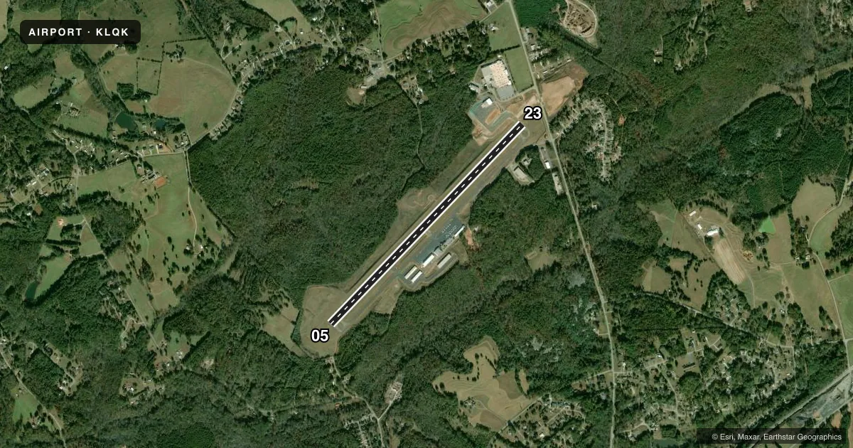
Airport sketch
Runways drawn to scale from FAA survey coordinates, rendered over satellite imagery. Not for navigation.
Approaches & charts
Services on the field
Fuel grades, oxygen, maintenance, ramp storage and lighting — as declared to the FAA by the airport operator.
Fuel & services
- Fuel
- 100LLA
- Oxygen (bottled)
- Not available
- Oxygen (bulk)
- Not available
- Airframe repair
- Minor
- Power plant repair
- Major
- Other services
- INSTR,RNTL
Ramp & ground
- Transient storage
- Tie-down
- Hangar
- Landing fee
- No fee published
- Customs
- Not available
- Lighting schedule
- SEE RMK
- Beacon schedule
- SS-SR
- Beacon
- White / Green (civil land)(WG)
- Wind indicator
- Lighted
- Segmented circle
- Yes
Fuel & FBOs
Cheapest 100LL and Jet A on the field and nearby. Always confirm with the FBO before taxi.
Airport notes
Surface conditions, obstructions, local procedures, lighting outages and other notes published with each FAA cycle.
General notes
- NOISE ABATEMENT PROC IN EFCT, PHONE 864-843-5803.
- FOR CD CTC GREER APCH AT 864-877-8275. WHEN GREER APCH CLSD, FOR CD CTC ATLANTA ARTCC AT 770-210-7692.
- ULTRALIGHT OPS AREA SOUTH OF RWY/REQ PRIOR CDN. CALL 864-843-5803 FOR INFO.
Lighting notes
- ACTVT PAPI RWY 05 & 23; MIRL RWY 05/23 - CTAF.
VFR map & nearby airports
VFR sectional. Tap any ICAO chip to open that airport.
Key facts · KLQK
Answer card- ICAO
- KLQK
- Name
- PICKENS COUNTY
- Location
- PICKENS, SOUTH CAROLINA
- Elevation
- 1,013.4 ft MSL
- Traffic pattern altitude
- 2,013.4 ft MSL (1,000 AGL)
- Control tower
- Non-towered (use CTAF)
- Total runways
- 1
- Longest runway
- 05/23 · 5,002 ft
- Published ILS approaches
- 0
- Published frequencies
- 4
- Magnetic variation
- 4°
- Current flight rules
- VFR
- Current wind
- 000° at 0 kt
- Favored runway now
- –
Pickens County Airport sits in Pickens, South Carolina. The field elevation is 1,013.4 ft MSL. It has one runway, 05/23, which is 5,002 ft long and paved with asphalt. There is no control tower. Pattern altitude is not published. Use 1,000 ft AGL for light piston traffic unless the current Chart Supplement says otherwise.
No ILS approaches are published here. CTAF and UNICOM are both 122.8. Greer Approach handles clearance delivery at 864-877-8275. When Greer Approach is closed, clearance delivery goes through Atlanta ARTCC at 770-210-7692. The published remarks also say noise abatement procedures are in effect. Call the airport at 864-843-5803 before arrival if you need the local procedure.
On the field, Pickens County Airport carries AVGAS 100LL and JET A. PAPI is available on runways 05 and 23. Medium intensity runway lighting is also on 05 and 23. It is controlled by CTAF. There is an ultralight operations area south of the runway. Prior coordination is required. For a first-time arrival, the main things to plan for are the non-towered environment, the published noise abatement and the local coordination needed for ultralights.