METAR & TAF KCEU
Current METAR
Observed 01:54Z
KCEU 270154Z AUTO 00000KT 10SM FEW055 28/24 A2989 RMK AO2 SLP111 T02780239
- Wind
- 000° @ 0 kt
- Visibility
- 10 SM
- Temp / Dew
- 28°C / 24°C
- Altimeter
- 29.89 inHg
- Clouds
- FEW
- Density alt
- 2,702 ft
- Ceiling
- Unlimited
- Rules
- VFR
Airport info & contacts
Manager on record, flight service, ARTCC, attendance schedule and pattern altitude — published by the FAA and refreshed every 28 days.
Location
- From city
- 3 NM W
- VFR sectional
- ATLANTA
- ARTCC
- ZTL · ATLANTA
- NOTAM facility
- CEU (NOTAM-D)
Airport manager
- Name
- JEFF GARRISON
- Phone
- 864-882-2959
- Address
- 365 AIRPORT RD, SENECA SC 29678
Flight service · Hours
- FSS AND
- ANDERSON1-800-WX-BRIEF
- Attendance
- MON-SAT · 0800-1800
- SUN · 0900-1700
Frequencies
Tap any row to copy the frequency to your clipboard.
Runways & pattern
Full pagePattern entry · RWY 07
RIGHT TRAFFICRunway end performance
| End | TORA | TODA | ASDA | LDA | VGSI | Approach lights | Obstruction |
|---|---|---|---|---|---|---|---|
| 07 | — | — | — | — | PAPI 2-box left(3°) | — | 26', tree, 583' from thr, 81' R of cntrln, slope 14 |
| 25 | — | — | — | — | PAPI 2-box left(3°) | — | — |
Declared distances in feet. TORA = takeoff run available, TODA = takeoff distance, ASDA = accelerate-stop, LDA = landing distance.
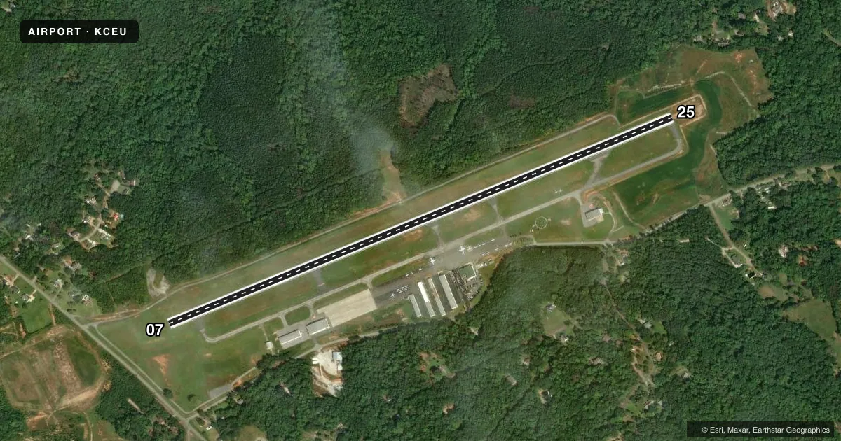
Airport sketch
Runways drawn to scale from FAA survey coordinates, rendered over satellite imagery. Not for navigation.
Approaches & charts
Services on the field
Fuel grades, oxygen, maintenance, ramp storage and lighting — as declared to the FAA by the airport operator.
Fuel & services
- Fuel
- 100LLA
- Oxygen (bottled)
- Not available
- Oxygen (bulk)
- Not available
- Airframe repair
- Major
- Power plant repair
- Major
- Other services
- INSTR,PAJA,RNTL,TOW
Ramp & ground
- Transient storage
- Tie-down
- Hangar
- Landing fee
- No fee published
- Customs
- Not available
- Lighting schedule
- SEE RMK
- Beacon schedule
- SS-SR
- Beacon
- White / Green (civil land)(WG)
- Wind indicator
- Lighted
- Segmented circle
- Yes
Fuel & FBOs
Cheapest 100LL and Jet A on the field and nearby. Always confirm with the FBO before taxi.
Airport notes
Surface conditions, obstructions, local procedures, lighting outages and other notes published with each FAA cycle.
General notes
- NO LINE-OF-SIGHT BETWEEN RWY ENDS.
- ACFT MAY BE OPERATING FROM PVT ARPT 1 NM WEST-NORTHWEST OF ARPT.
- RY 7/25 PAEW ADJ 1200-2100 DLY.
- FOR CD CTC GREER APCH AT 864-877-8275. WHEN GREER APCH CLSD, FOR CD CTC ATLANTA ARTCC AT 770-210-7692.
Lighting notes
- ACTVT REIL RWY 07 & 25; PAPI RWY 07 & 25; MIRL RWY 07/25 - CTAF.
VFR map & nearby airports
VFR sectional. Tap any ICAO chip to open that airport.
Key facts · KCEU
Answer card- ICAO
- KCEU
- Name
- OCONEE COUNTY RGNL
- Location
- CLEMSON, SOUTH CAROLINA
- Elevation
- 890.6 ft MSL
- Traffic pattern altitude
- 1,890.6 ft MSL (1,000 AGL)
- Control tower
- Non-towered (use CTAF)
- Total runways
- 1
- Longest runway
- 07/25 · 5,000 ft
- Published ILS approaches
- 0
- Published frequencies
- 4
- Magnetic variation
- 5°
- Current flight rules
- VFR
- Current wind
- 000° at 0 kt
- Favored runway now
- –
Oconee County Rgnl Airport sits in Clemson, South Carolina. The field elevation is 890.6 ft MSL. It has one runway, 07/25, which is 5,000 ft long and paved. There is no control tower. Greer Approach handles clearance delivery, with Atlanta ARTCC used when Greer is closed.
No ILS approaches are published here. The pattern altitude is not published in the facts, so use the standard 1,000 ft AGL for light piston operations unless the current FAA Chart Supplement says otherwise. Runway 07 and 25 have runway end identifier lights and precision approach path indicators. The runway also has medium intensity lighting. Pilot-activated lighting is noted as adjacent from 1200 to 2100 daily.
Oconee County Regional Airport is the on-field FBO. It carries AVGAS 100LL and Jet A Prist. There is no line-of-sight between the runway ends, so plan your taxi and runway checks with that in mind. Aircraft may also be operating from a private airport 1 NM west-northwest of the field. This is a non-towered airport, so listen carefully on CTAF 122.7 and expect local traffic flow to be the main factor on arrival and departure.