METAR & TAF KEBA
Current METAR
Observed 12:55Z
KEBA 271255Z AUTO 31003KT 10SM CLR 25/24 A2990 RMK AO2 T02550239
- Wind
- 310° @ 3 kt
- Visibility
- 10 SM
- Temp / Dew
- 25°C / 24°C
- Altimeter
- 29.90 inHg
- Clouds
- CLR
- Density alt
- 1,987 ft
- Ceiling
- Unlimited
- Rules
- VFR
Airport info & contacts
Manager on record, flight service, ARTCC, attendance schedule and pattern altitude — published by the FAA and refreshed every 28 days.
Location
- From city
- 2 NM E
- VFR sectional
- ATLANTA
- ARTCC
- ZTL · ATLANTA
- NOTAM facility
- MCN (NOTAM-D)
Airport manager
- Name
- RANDY HARALSON, FBO
- Phone
- 706-283-2035
- Address
- 1136 VON TRINA RD, ELBERTON GA 30635
Flight service · Hours
- FSS MCN
- MACON1-800-WX-BRIEF
- Attendance
- MON-SAT · 0800-1800
- SUN · 1300-1800
Frequencies
Tap any row to copy the frequency to your clipboard.
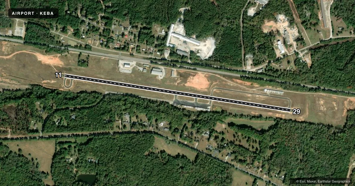
Runways & pattern
Full pagePattern entry · RWY 29
LEFT TRAFFICRunway end performance
| End | TORA | TODA | ASDA | LDA | VGSI | Approach lights | Obstruction |
|---|---|---|---|---|---|---|---|
| 11 | — | — | — | — | PAPI 2-box left(3.75°) | — | 87', trees, 1865' from thr, 190' R of cntrln, slope 19 |
| 29 | — | — | — | — | PAPI 2-box left(3.75°) | — | 46', trees, 460' from thr, 260' R of cntrln, slope 5 |
Declared distances in feet. TORA = takeoff run available, TODA = takeoff distance, ASDA = accelerate-stop, LDA = landing distance.
Airport sketch
Runways drawn to scale from FAA survey coordinates, rendered over satellite imagery. Not for navigation.
Approaches & charts
Services on the field
Fuel grades, oxygen, maintenance, ramp storage and lighting — as declared to the FAA by the airport operator.
Fuel & services
- Fuel
- 100LL
- Oxygen (bottled)
- Not available
- Oxygen (bulk)
- Not available
- Airframe repair
- Not available
- Power plant repair
- Not available
- Other services
- INSTR
Ramp & ground
- Transient storage
- Tie-down
- Landing fee
- No fee published
- Customs
- Not available
- Lighting schedule
- SEE RMK
- Beacon schedule
- SS-SR
- Beacon
- White / Green (civil land)(WG)
- Wind indicator
- Lighted
- Segmented circle
- Yes
Fuel & FBOs
Cheapest 100LL and Jet A on the field and nearby. Always confirm with the FBO before taxi.
Airport notes
Surface conditions, obstructions, local procedures, lighting outages and other notes published with each FAA cycle.
General notes
- DEER ON & INVOF ARPT.
- ROAD LCTD 200 FT SOUTH OF RCL.
- RISING TRRN 10 FT HI LCTD NORTH OF RWY 11/29 STARTING FM RCL.
- RWY 29 APCH: TREES 36 FT TALL, LCTD 452 FT FROM RWY END, 280 FT SOUTH OF RCL. TREES 57 FT TALL, LCTD 770 FT FROM RWY END, 295 FT SOUTH OF RCL. TREES 66 FT TALL, LCTD 992 FT FM RWY END, 30 FT SOUTH OF RCL.
- FOR CD CTC ATLANTA ARTCC AT 770-210-7692.
Lighting notes
- ACTVT PAPI RWY 11 & 29; MIRL RWY 11/29 - CTAF. MIRL RWY 11/29 UNAVBL DURG DALGT HRS, ON PHOTOCELL.
Approach & departure obstructions
- 11RWY 11 PAPI UNUSBL 6 DEGS RIGHT OF RCL.
- 29RWY 29 PAPI UNUSBL 8 DEGS LEFT OF RCL.
VFR map & nearby airports
VFR sectional. Tap any ICAO chip to open that airport.
Key facts · KEBA
Answer card- ICAO
- KEBA
- Name
- ELBERT COUNTY-PATZ FLD
- Location
- ELBERTON, GEORGIA
- Elevation
- 614.5 ft MSL
- Traffic pattern altitude
- 1,614.5 ft MSL (1,000 AGL)
- Control tower
- Non-towered (use CTAF)
- Total runways
- 1
- Longest runway
- 11/29 · 5,004 ft
- Published ILS approaches
- 0
- Published frequencies
- 2
- Magnetic variation
- 6°
- Current flight rules
- VFR
- Current wind
- 310° at 3 kt
- Favored runway now
- RWY 29
Elbert County-Patz Fld is in Elberton, Georgia. The field elevation is 614.5 ft MSL. It has one runway, 11/29, which is 5,004 ft long and paved with asphalt. There is no control tower. CTAF and UNICOM are both 122.8. No ILS approaches are published here.
Pattern altitude is not published. Use the standard 1,000 ft AGL pattern for light piston operations unless the current Chart Supplement says otherwise. Haralson Aviation is on the field. It carries 100LL. Runway lighting and the PAPI on 11 and 29 are activated by CTAF. The runway lights are on a photocell at night and are unavailable in daylight.
The published remarks matter here. Runway 29 has a PAPI that is unusable left of centerline. There are trees near the 29 approach path. There is also a road south of the runway centerline. Rising terrain is north of the runway. Deer are reported on and near the airport. For clearance delivery, contact Atlanta ARTCC at 770-210-7692. A first-time pilot should plan the arrival with those obstacles in mind, especially if flying a low approach or arriving after dark.