METAR & TAF KCPP
Current METAR
Observed 13:15Z
KCPP 271315Z AUTO 00000KT 8SM CLR 27/24 A2990 RMK AO2
- Wind
- 000° @ 0 kt
- Visibility
- 8 SM
- Temp / Dew
- 27°C / 24°C
- Altimeter
- 29.90 inHg
- Clouds
- CLR
- Density alt
- 2,319 ft
- Ceiling
- Unlimited
- Rules
- VFR
Airport info & contacts
Manager on record, flight service, ARTCC, attendance schedule and pattern altitude — published by the FAA and refreshed every 28 days.
Location
- From city
- 3 NM NE
- VFR sectional
- ATLANTA
- ARTCC
- ZTL · ATLANTA
- NOTAM facility
- MCN (NOTAM-D)
Airport manager
- Name
- BYRON LOMBARD
- Phone
- (706) 453-2715
- Address
- 1034 SILVER DRIVE, GREENSBORO GA 30642
Flight service · Hours
- FSS MCN
- MACON1-800-WX-BRIEF
- Attendance
- 0800-1700
Frequencies
Tap any row to copy the frequency to your clipboard.
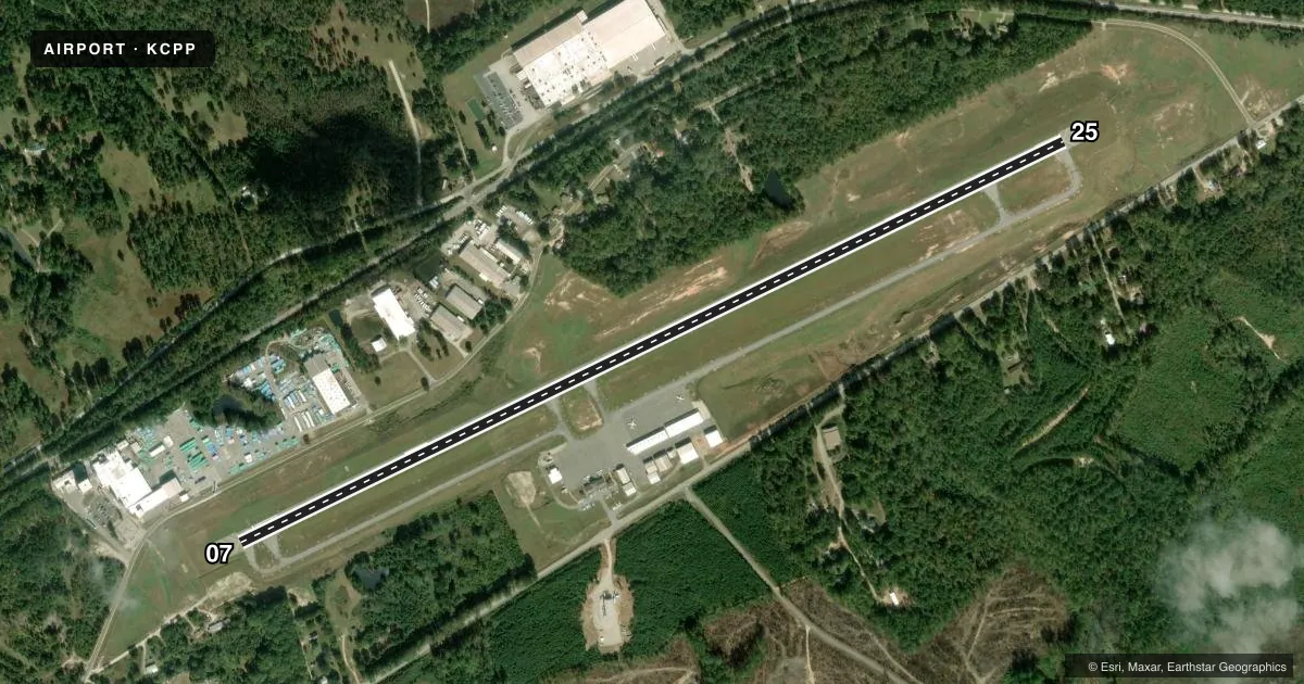
Runways & pattern
Full pagePattern entry · RWY 07
LEFT TRAFFICRunway end performance
| End | TORA | TODA | ASDA | LDA | VGSI | Approach lights | Obstruction |
|---|---|---|---|---|---|---|---|
| 07 | 5,500' | 5,500' | 5,500' | 5,401' | PAPI 2-box left(3°) | — | 27', trees, 201' from thr, 215' R of cntrln, slope 0 |
| 25 | 5,500' | 5,500' | 5,500' | 5,500' | PAPI 4-box left(3°) | — | 65', trees, 1110' from thr, 359' R of cntrln, slope 14 |
Declared distances in feet. TORA = takeoff run available, TODA = takeoff distance, ASDA = accelerate-stop, LDA = landing distance.
Airport sketch
Runways drawn to scale from FAA survey coordinates, rendered over satellite imagery. Not for navigation.
Approaches & charts
ILS · 1
Services on the field
Fuel grades, oxygen, maintenance, ramp storage and lighting — as declared to the FAA by the airport operator.
Fuel & services
- Fuel
- 100LLA+
- Oxygen (bottled)
- Not available
- Oxygen (bulk)
- Not available
- Airframe repair
- Not available
- Power plant repair
- Not available
- Other services
- INSTR,RNTL
Ramp & ground
- Transient storage
- Tie-down
- Landing fee
- No fee published
- Lighting schedule
- SEE RMK
- Beacon schedule
- SS-SR
- Beacon
- White / Green (civil land)(WG)
- Wind indicator
- Lighted
- Segmented circle
- Yes
Fuel & FBOs
Cheapest 100LL and Jet A on the field and nearby. Always confirm with the FBO before taxi.
Airport notes
Surface conditions, obstructions, local procedures, lighting outages and other notes published with each FAA cycle.
General notes
- GCO AVBL ON FREQ 121.725 ATL APP OR 678-364-6131 (PREFERRED).
- DEER ON & INVOF ARPT.
Lighting notes
- HIRL RWY 07/25 PRESET MED INTST DUSK-DAWN. TO INCR INTST OR ACTVT PAPI RWY 07 & 25; HIRL RWY 07/25 - CTAF.
Fuel notes
- 100LLSELF FUEL WITH CREDIT CARD AVBL 0800-1700, FULL SVC AVBL 0800-1700, AFTER HOURS CALL 706-453-2715 OR 706-817-8226.
Approach & departure obstructions
- 07FENCE 20 FT TREES 100 FT FM E.O.R, 200 FT RIGHT.
- 07APCH RATIO 20:1 TO DSPLCD THR, TREES 240 FT OUT, 200 FT RIGHT.
Other notes
- VFR USE ONLY.
- MANAGERFAX 706-453-7108.
VFR map & nearby airports
VFR sectional. Tap any ICAO chip to open that airport.
Key facts · KCPP
Answer card- ICAO
- KCPP
- Name
- GREENE COUNTY RGNL
- Location
- GREENSBORO, GEORGIA
- Elevation
- 688.5 ft MSL
- Traffic pattern altitude
- 1,688.5 ft MSL (1,000 AGL)
- Control tower
- Non-towered (use CTAF)
- Total runways
- 1
- Longest runway
- 07/25 · 5,500 ft
- Published ILS approaches
- 1
- Published frequencies
- 4
- Magnetic variation
- 5°
- Current flight rules
- VFR
- Current wind
- 000° at 0 kt
- Favored runway now
- –
Greene County Rgnl is in Greensboro, Georgia. The field elevation is 688.5 ft MSL. It has one runway, 07/25, which is 5,500 ft long and paved with asphalt. There is no control tower. The airport publishes 1 ILS approach to runway 25. The pattern altitude is not published, so plan on the standard 1,000 ft AGL for light piston traffic unless the current Chart Supplement says otherwise.
Spirit Aviation is on the field. It carries 100LL, Jet A and Jet A Prist. Self-serve 100LL is available from 0800 to 1700. Full service is also available from 0800 to 1700. After hours fuel contact is listed in the remarks. The runway lights are preset to medium intensity from dusk to dawn. If you need higher intensity or the PAPI on 07 or 25, activate it through CTAF.
This is VFR use only, so verify your plan before launch. Deer are reported on and near the airport. Runway 07 also has published obstacle notes near the departure end. The field uses CTAF 122.8. Atlanta Approach is listed on 132.475 and 291.1. The GCO on 121.725 is available, which can help with approach communications by phone if needed.