METAR & TAF KHQU
Current METAR
Observed 13:35Z
KHQU 271335Z AUTO 00000KT 10SM CLR 27/24 A2994 RMK AO2
- Wind
- 000° @ 0 kt
- Visibility
- 10 SM
- Temp / Dew
- 27°C / 24°C
- Altimeter
- 29.94 inHg
- Clouds
- CLR
- Density alt
- 2,037 ft
- Ceiling
- Unlimited
- Rules
- VFR
Airport info & contacts
Manager on record, flight service, ARTCC, attendance schedule and pattern altitude — published by the FAA and refreshed every 28 days.
Location
- From city
- 4 NM N
- VFR sectional
- ATLANTA
- ARTCC
- ZTL · ATLANTA
- NOTAM facility
- MCN (NOTAM-D)
Airport manager
- Name
- TERESA SMITH
- Phone
- 706-597-7378
- Address
- CITY OF THOMSON, 210 RAILROAD STREET, THOMSON GA 30824
Flight service · Hours
- FSS MCN
- MACON1-800-WX-BRIEF
- Attendance
- 0800-1700
Frequencies
Tap any row to copy the frequency to your clipboard.
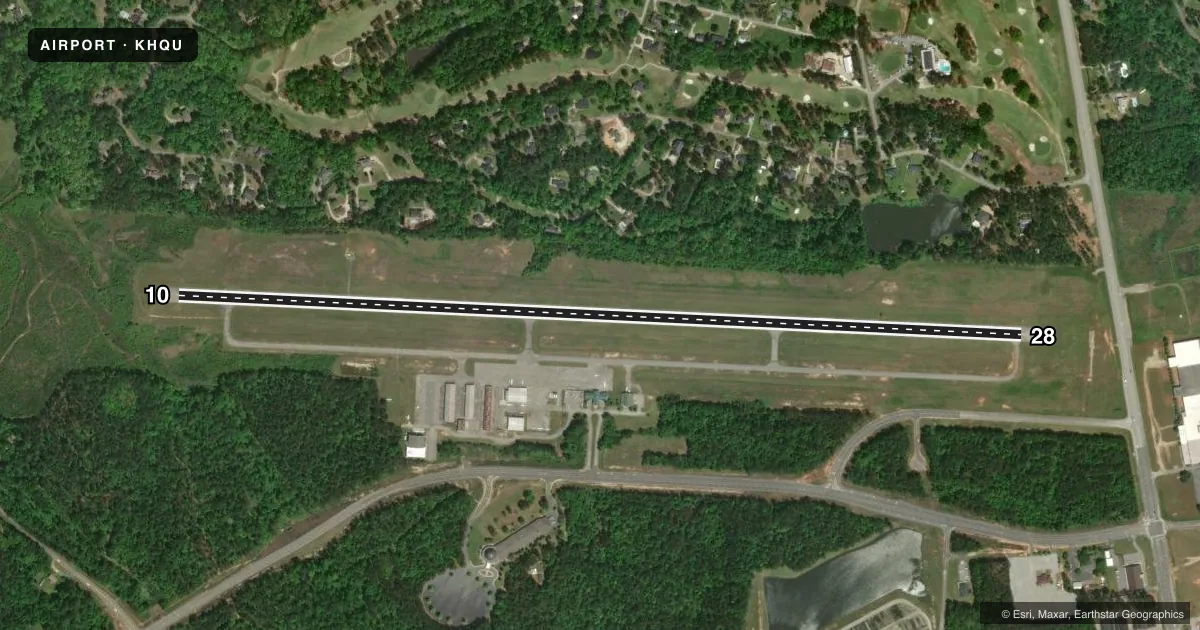
Runways & pattern
Full pagePattern entry · RWY 10
LEFT TRAFFICRunway end performance
| End | TORA | TODA | ASDA | LDA | VGSI | Approach lights | Obstruction |
|---|---|---|---|---|---|---|---|
| 10 | 5,514' | 5,514' | 5,514' | 5,215' | PAPI 2-box left(3°) | — | 103', trees, 2878' from thr, 57' R of cntrln, slope 26 |
| 28 | 5,514' | 5,514' | 5,373' | 5,179' | PAPI 2-box left(3.5°) | — | 83', trees, 1694' from thr, 212' R of cntrln, slope 18 |
Declared distances in feet. TORA = takeoff run available, TODA = takeoff distance, ASDA = accelerate-stop, LDA = landing distance.
Airport sketch
Runways drawn to scale from FAA survey coordinates, rendered over satellite imagery. Not for navigation.
Approaches & charts
ILS · 1
Services on the field
Fuel grades, oxygen, maintenance, ramp storage and lighting — as declared to the FAA by the airport operator.
Fuel & services
- Fuel
- 100LLA+
- Oxygen (bottled)
- HIGH/LOW
- Oxygen (bulk)
- HIGH/LOW
- Airframe repair
- Minor
- Power plant repair
- Minor
- Other services
- CHTR,INSTR,RNTL
Ramp & ground
- Transient storage
- Tie-down
- Hangar
- Landing fee
- No fee published
- Customs
- Not available
- Lighting schedule
- SEE RMK
- Beacon schedule
- SS-SR
- Beacon
- White / Green (civil land)(WG)
- Wind indicator
- Lighted
- Segmented circle
- Yes
Fuel & FBOs
Cheapest 100LL and Jet A on the field and nearby. Always confirm with the FBO before taxi.
Airport notes
Surface conditions, obstructions, local procedures, lighting outages and other notes published with each FAA cycle.
General notes
- DEER ON RWY AT NGT.
- FOR CD CTC AUGUSTA APCH AT 706-771-1777, WHEN APCH CLSD CTC ATLANTA ARTCC AT 770-210-7692.
- RCO RELAY FREQ 124.45 AVAIL FOR GND USE.
Lighting notes
- ACTVT PAPI RWY 10 & 28; HIRL RWY 10/28 - CTAF.
Approach & departure obstructions
- 2850 FT TREES 480 FT RIGHT AT 0 FT - 200 FT FM RWY END.
Other notes
- OWNERMCDUFFIE COUNTY - 210 RAIL ROAD STREET, THOMSON, GA 30824.
VFR map & nearby airports
VFR sectional. Tap any ICAO chip to open that airport.
Key facts · KHQU
Answer card- ICAO
- KHQU
- Name
- THOMSON/MCDUFFIE COUNTY
- Location
- THOMSON, GEORGIA
- Elevation
- 501.3 ft MSL
- Traffic pattern altitude
- 1,501.3 ft MSL (1,000 AGL)
- Control tower
- Non-towered (use CTAF)
- Total runways
- 1
- Longest runway
- 10/28 · 5,514 ft
- Published ILS approaches
- 1
- Published frequencies
- 4
- Magnetic variation
- 4°
- Current flight rules
- VFR
- Current wind
- 000° at 0 kt
- Favored runway now
- –
Thomson/McDuffie County Airport sits in Thomson, Georgia. Field elevation is 501.3 ft MSL. It has one runway, 10/28, which is 5,514 ft long. The airport is not towered. Augusta Approach handles clearance delivery. When approach is closed, contact Atlanta ARTCC. The field has one ILS approach to runway 10. Pattern altitude is not published. Use 1,000 ft AGL for light piston traffic unless the current Chart Supplement says otherwise.
Spirit Aviation is on the field. It carries 100LL, Jet A and Jet A Prist. CTAF and UNICOM are both 122.8. The published remarks also note remote relay use on 124.45 for ground. PAPI is available for runways 10 and 28. High intensity runway lighting is available for both runway ends on CTAF. Deer are present on the runway at night. So a night arrival deserves extra caution.
Runway 28 has a published obstruction note. There are 50-foot trees off the right side near the departure end. That matters if you are planning a short-field climb or a low departure profile. This is a non-towered field with a single asphalt runway. Check the current Chart Supplement for any noise or curfew restrictions before flying into the field. Also verify current approach and clearance procedures with the airport operator or Augusta Approach before departure.