METAR & TAF 65J
65J does not publish a METAR.
Showing the nearest reporting station: KHQU (THOMSON/MCDUFFIE COUNTY) · 19.6 NM away. Conditions at 65J may differ.
METAR · KHQU
Observed 13:35Z
KHQU 271335Z AUTO 00000KT 10SM CLR 27/24 A2994 RMK AO2
- Wind
- 000° @ 0 kt
- Visibility
- 10 SM
- Temp / Dew
- 27°C / 24°C
- Altimeter
- 29.94 inHg
- Clouds
- CLR
- Density alt
- 1,973 ft
- Ceiling
- Unlimited
- Rules
- VFR
Airport info & contacts
Manager on record, flight service, ARTCC, attendance schedule and pattern altitude — published by the FAA and refreshed every 28 days.
Location
- From city
- 1 NM N
- VFR sectional
- ATLANTA
- ARTCC
- ZTL · ATLANTA
- NOTAM facility
- MCN (NOTAM-D)
Airport manager
- Name
- ARTY THRIFT
- Phone
- 706-547-3000
- Address
- CITY HALL, PO BOX 125, WRENS GA 30833
Flight service · Hours
- FSS MCN
- MACON1-800-WX-BRIEF
- Attendance
- Unattended
Frequencies
Tap any row to copy the frequency to your clipboard.
Runways & pattern
Full pagePattern entry · RWY 11
LEFT TRAFFICRunway end performance
| End | TORA | TODA | ASDA | LDA | VGSI | Approach lights | Obstruction |
|---|---|---|---|---|---|---|---|
| 11 | — | — | — | — | — | — | 5', gnd, 201' from thr, 100' R of cntrln, slope 0 |
Declared distances in feet. TORA = takeoff run available, TODA = takeoff distance, ASDA = accelerate-stop, LDA = landing distance.
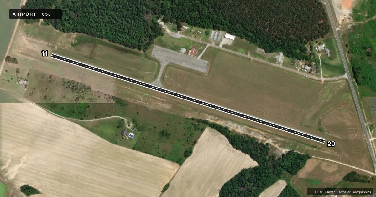
Airport sketch
Runways drawn to scale from FAA survey coordinates, rendered over satellite imagery. Not for navigation.
Approaches & charts
Services on the field
Fuel grades, oxygen, maintenance, ramp storage and lighting — as declared to the FAA by the airport operator.
Fuel & services
- Fuel
- Not available
- Oxygen (bottled)
- Not available
- Oxygen (bulk)
- Not available
- Airframe repair
- Not available
- Power plant repair
- Not available
Ramp & ground
- Transient storage
- Tie-down
- Landing fee
- No fee published
- Customs
- Not available
- Lighting schedule
- SEE RMK
- Beacon schedule
- SS-SR
- Beacon
- White / Green (civil land)(WG)
- Wind indicator
- Lighted
- Segmented circle
- Yes
Fuel & FBOs
Cheapest 100LL and Jet A on the field and nearby. Always confirm with the FBO before taxi.
Airport notes
Surface conditions, obstructions, local procedures, lighting outages and other notes published with each FAA cycle.
General notes
- FOR CD CTC AUGUSTA APCH AT 706-771-1777, WHEN APCH CLSD CTC ATLANTA ARTCC AT 770-210-7692.
Lighting notes
- ACTVT MIRL RY 11/29 - CTAF.
Approach & departure obstructions
- 113-5FT GROUND, 120FT R, 0-200FT FROM RY END.
- 291 FT GROUND, 122 FT L, 0-100 FT FM RWY END.
- 11SLOPE IS 21:1 TO THLD. ROAD 433 FT FM END OF RWY.
Other notes
- VFR OPS ONLY.
- MANAGERCITY ADMINISTRATOR
VFR map & nearby airports
VFR sectional. Tap any ICAO chip to open that airport.
Key facts · 65J
Answer card- ICAO
- 65J
- Name
- WRENS MEML
- Location
- WRENS, GEORGIA
- Elevation
- 450 ft MSL
- Traffic pattern altitude
- 1,450 ft MSL (1,000 AGL)
- Control tower
- Non-towered (use CTAF)
- Total runways
- 1
- Longest runway
- 11/29 · 3,000 ft
- Published ILS approaches
- 0
- Published frequencies
- 2
- Magnetic variation
- 3°
- Current flight rules
- VFR
- Current wind
- 000° at 0 kt
- Favored runway now
- –
Wrens Meml Airport (65J) sits in Wrens, Georgia. Field elevation is 450 ft MSL. The airport has one runway. Runway 11/29 is 3,000 ft long with an asphalt surface. There is no control tower. CTAF and UNICOM are both 122.7.
No ILS approaches are published here. Pattern altitude is not published, so a light piston pilot should plan on the standard 1,000 ft AGL unless the current Chart Supplement says otherwise. This is a VFR-only field. The published remarks also note runway lighting on 11/29 is activated by the common traffic advisory frequency. That matters after dark because you need to key the radio to turn the lights on.
The published remarks list obstructions near both runway ends. Runway 11 has a road beyond the departure end plus low ground obstructions near the right side close to the threshold. Runway 29 has a low ground obstruction near the left side close to the threshold. That makes a careful look at the runway environment smart on arrival and departure. There are no on-field FBOs listed, so verify services with the airport operator or call the field on CTAF before you go. The airport manager is the city administrator. For clearance delivery, contact Augusta Approach. When Augusta Approach is closed, contact Atlanta ARTCC.