METAR & TAF KDNL
Current METAR
Observed 11:53Z
KDNL 271153Z AUTO 23003KT 10SM CLR 26/24 A2987 RMK AO2 SLP108 T02560239 10261 20250 51004
- Wind
- 230° @ 3 kt
- Visibility
- 10 SM
- Temp / Dew
- 26°C / 24°C
- Altimeter
- 29.87 inHg
- Clouds
- CLR
- Density alt
- 1,906 ft
- Ceiling
- Unlimited
- Rules
- VFR
Airport info & contacts
Manager on record, flight service, ARTCC, attendance schedule and pattern altitude — published by the FAA and refreshed every 28 days.
Location
- From city
- 1 NM W
- VFR sectional
- ATLANTA
- ARTCC
- ZTL · ATLANTA
- NOTAM facility
- DNL (NOTAM-D)
Airport manager
- Name
- STEVE GAY, PRES
- Phone
- 706-733-8970
- Address
- AUGUSTA AVIATION (FBO), 1775 HIGHLAND AVE, AUGUSTA GA 30904
Flight service · Hours
- FSS MCN
- MACON1-800-WX-BRIEF
- Attendance
- 0700-DUSK
Frequencies
Tap any row to copy the frequency to your clipboard.
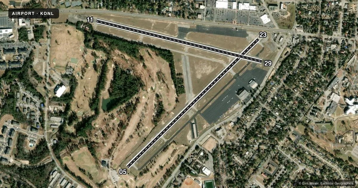
Runways & pattern
Full pagePattern entry · RWY 23
LEFT TRAFFIC| Runway | Heading (°M) | Length | Surface | Traffic |
|---|---|---|---|---|
| 05/23Favored | 42° / 222° | 4,002 ft | ASPH | Standard L |
| 11/29 | 100° / 280° | 3,733 ft | ASPH | Standard L |
Runway end performance
| End | TORA | TODA | ASDA | LDA | VGSI | Approach lights | Obstruction |
|---|---|---|---|---|---|---|---|
| 05 | — | — | — | — | PAPI 2-box left(3°) | — | 10', tree, 280' from thr, 243' R of cntrln, slope 8 |
| 23 | — | — | — | — | PAPI 2-box left(3.3°) | — | 15', road, 201' from thr, 80' R of cntrln, slope 0 |
| 11 | 3,733' | 3,733' | 3,733' | 3,407' | PAPI 4-box left(3.5°) | — | 25', road, 201' from thr, 145' R of cntrln, slope 0 |
| 29 | 3,733' | 3,733' | 3,733' | 3,419' | — | — | 15', road, 201' from thr, 180' R of cntrln, slope 0 |
Declared distances in feet. TORA = takeoff run available, TODA = takeoff distance, ASDA = accelerate-stop, LDA = landing distance.
Airport sketch
Runways drawn to scale from FAA survey coordinates, rendered over satellite imagery. Not for navigation.
Approaches & charts
Services on the field
Fuel grades, oxygen, maintenance, ramp storage and lighting — as declared to the FAA by the airport operator.
Fuel & services
- Fuel
- 100LLA1+
- Oxygen (bottled)
- HIGH/LOW
- Oxygen (bulk)
- HIGH/LOW
- Airframe repair
- Major
- Power plant repair
- Major
- Other services
- AMB,AVNCS,CHTR,INSTR,RNTL,SALES
Ramp & ground
- Transient storage
- Tie-down
- Hangar
- Landing fee
- No fee published
- Customs
- Not available
- Lighting schedule
- SEE RMK
- Beacon schedule
- SS-SR
- Beacon
- White / Green (civil land)(WG)
- Wind indicator
- Lighted
- Segmented circle
- No
Fuel & FBOs
Cheapest 100LL and Jet A on the field and nearby. Always confirm with the FBO before taxi.
Airport notes
Surface conditions, obstructions, local procedures, lighting outages and other notes published with each FAA cycle.
General notes
- PILOTS SHOULD BE ALERT FOR TURBO-JET TFC TRANSITING THE TFC AREA ENR TO BUSH FLD 6 MILES SOUTH.
Lighting notes
- ACTVT REIL RWY 05, 11, 23; PAPI RWY 05, 11, & 23; MIRL RWY 05/23 & 11/29 - CTAF.
Approach & departure obstructions
- 116 FT FENCE 190 FT FM THLD 94 FT RIGHT.
- 236 FT FENCE 190 FT FM THLD 125 FT RIGHT.
- 11RWY 11 PAPI UNUSBL BYD 3 DEG LEFT OF RWY CNTRLN, PAPI IS BAFFLED.
- 05APCH RATIO 50:1 TO DSPLCD THLD.
- 11APCH RATIO 0:1 TO DSPLCD THLD; 20 FT ROAD/FENCE AT DSPLCD THLD & 245 FT LEFT.
- 23APCH RATIO 16:1 TO DSPLCD THLD; 34FT LIGHT POLE, 577 FT FROM THLD, 213 FT RIGHT.
- 29APCH RATIO 13:1 TO DSPLCD THLD; +55 FT TREES 715 FT FROM THLD, 139 FT LEFT.
Other notes
- EXISTED PRIOR TO 1959.
VFR map & nearby airports
VFR sectional. Tap any ICAO chip to open that airport.
Key facts · KDNL
Answer card- ICAO
- KDNL
- Name
- DANIEL FLD
- Location
- AUGUSTA, GEORGIA
- Elevation
- 422.3 ft MSL
- Traffic pattern altitude
- 1,422.3 ft MSL (1,000 AGL)
- Control tower
- Non-towered (use CTAF)
- Total runways
- 2
- Longest runway
- 05/23 · 4,002 ft
- Published ILS approaches
- 0
- Published frequencies
- 4
- Magnetic variation
- 4°
- Current flight rules
- VFR
- Current wind
- 230° at 3 kt
- Favored runway now
- RWY 23
Daniel Field sits in Augusta, Georgia. Field elevation is 422.3 ft MSL. The airport has two asphalt runways. The longest is runway 05/23 at 4,002 ft. There is no control tower. Towered traffic services are handled through Augusta approach and departure frequencies. No ILS approaches are published here, so plan with that in mind if the weather is marginal.
The published pattern altitude is not listed. Use the standard 1,000 ft AGL pattern unless the current FAA Chart Supplement says otherwise. Augusta Aviation is on the field. It carries 100LL and Jet A. Call (706) 733-8970 for current service details before you go.
This field has several published obstacle notes near the displaced thresholds. Runway 11 has a road and fence near the threshold. Runway 23 has a light pole and a fence near the approach path. Runway 29 has tall trees near the threshold area. Runway 11 also has a PAPI limitation left of centerline. The runway lights are CTAF controlled. Pilots should also watch for turbojet traffic transiting the pattern area en route to Bush Field six miles south. If you need current noise, curfew, or operational guidance, check the current FAA Chart Supplement or call the airport operator before departure.