METAR & TAF KAIK
Current METAR
Observed 07:35Z
KAIK 270735Z AUTO 00000KT 7SM CLR 24/23 A2989 RMK AO2 LTG DSNT S T02370234
- Wind
- 000° @ 0 kt
- Visibility
- 7 SM
- Temp / Dew
- 24°C / 23°C
- Altimeter
- 29.89 inHg
- Clouds
- CLR
- Density alt
- 1,773 ft
- Ceiling
- Unlimited
- Rules
- VFR
Airport info & contacts
Manager on record, flight service, ARTCC, attendance schedule and pattern altitude — published by the FAA and refreshed every 28 days.
Location
- From city
- 5 NM N
- VFR sectional
- CHARLOTTE
- ARTCC
- ZTL · ATLANTA
- NOTAM facility
- AND (NOTAM-D)
Airport manager
- Name
- CHRISTOPHER MCCAULEY
- Phone
- 803-502-4860
- Address
- 129 AVIATION BLVD, 214 PARK AVENUE, SW, AIKEN SC 29805
Flight service · Hours
- FSS AND
- ANDERSON1-800-WX-BRIEF
- Attendance
- 0700-1900
Frequencies
Tap any row to copy the frequency to your clipboard.
Runways & pattern
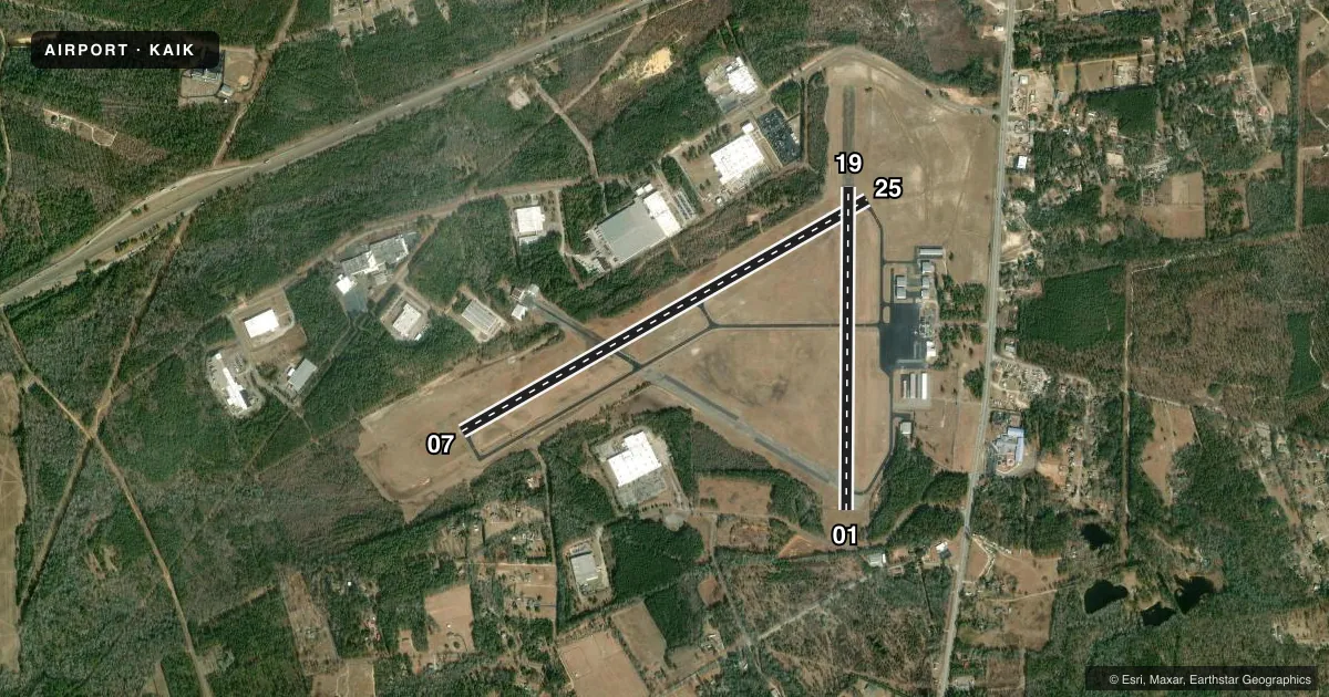
Full pagePattern entry · RWY 07
LEFT TRAFFIC| Runway | Heading (°M) | Length | Surface | Traffic |
|---|---|---|---|---|
| 07/25 | 54° / 234° | 5,500 ft | ASPH | Standard L |
| 01/19 | 354° / 174° | 3,800 ft | ASPH | Standard L |
Runway end performance
| End | TORA | TODA | ASDA | LDA | VGSI | Approach lights | Obstruction |
|---|---|---|---|---|---|---|---|
| 07 | — | — | — | — | PAPI 2-box left(3°) | — | — |
| 25 | — | — | — | — | PAPI 2-box left(3°) | ODALS | — |
| 01 | — | — | — | — | — | — | 55', tree, 574' from thr, 119' R of cntrln, slope 6 |
Declared distances in feet. TORA = takeoff run available, TODA = takeoff distance, ASDA = accelerate-stop, LDA = landing distance.
Airport sketch
Runways drawn to scale from FAA survey coordinates, rendered over satellite imagery. Not for navigation.
Approaches & charts
ILS · 1
Services on the field
Fuel grades, oxygen, maintenance, ramp storage and lighting — as declared to the FAA by the airport operator.
Fuel & services
- Fuel
- 100LLA
- Oxygen (bottled)
- Not available
- Oxygen (bulk)
- Not available
- Airframe repair
- Minor
- Power plant repair
- Minor
- Other services
- INSTR,RNTL
Ramp & ground
- Transient storage
- Tie-down
- Hangar
- Landing fee
- No fee published
- Customs
- Not available
- Lighting schedule
- SEE RMK
- Beacon schedule
- SS-SR
- Beacon
- White / Green (civil land)(WG)
- Wind indicator
- Yes
- Segmented circle
- Yes
Fuel & FBOs
Cheapest 100LL and Jet A on the field and nearby. Always confirm with the FBO before taxi.
Airport notes
Surface conditions, obstructions, local procedures, lighting outages and other notes published with each FAA cycle.
General notes
- FOR CD IF UNA TO CTC ON FSS FREQ, CTC AUGUSTA APCH AT 706-771-1777, WHEN APCH CLSD CTC COLUMBIA APCH AT 803-822-4511.
Lighting notes
- ACTVT ODALS RWY 25; MIRL RWY 07/25 - CTAF. PAPI RWY 07 & 25 OPER CONSLY.
VFR map & nearby airports
VFR sectional. Tap any ICAO chip to open that airport.
Key facts · KAIK
Answer card- ICAO
- KAIK
- Name
- AIKEN RGNL
- Location
- AIKEN, SOUTH CAROLINA
- Elevation
- 528.5 ft MSL
- Traffic pattern altitude
- 1,528.5 ft MSL (1,000 AGL)
- Control tower
- Non-towered (use CTAF)
- Total runways
- 2
- Longest runway
- 07/25 · 5,500 ft
- Published ILS approaches
- 1
- Published frequencies
- 8
- Magnetic variation
- 6°
- Current flight rules
- VFR
- Current wind
- 000° at 0 kt
- Favored runway now
- –
Aiken Rgnl is in Aiken, South Carolina. The field elevation is 528.5 ft MSL. It has two asphalt runways. The longest is 07/25 at 5,500 ft. The other runway is 01/19 at 3,800 ft. There is no control tower, so plan for CTAF traffic and self-announced position calls. Pattern altitude is not published. For light piston traffic, use 1,000 ft AGL unless the current Chart Supplement says otherwise.
There is one ILS approach at KAIK. It serves runway 07. The airport also has approach lighting on runway 25. Medium intensity runway lights are on 07/25 and are controlled on CTAF. The PAPI on 07 and 25 operates continuously. That helps after sunset. You still need to verify current procedures before you go.
Aiken Aviation is on the field. It carries 100LL and Jet A. For clearance delivery, the published remarks say to contact Augusta Approach if you cannot reach flight service on the listed frequency. If Augusta Approach is closed, use Columbia Approach. That matters for IFR planning here. First-time visitors should also expect a non-towered environment with Augusta-area approach control nearby. Stay sharp on radio work and sequencing.