METAR & TAF 6J0
6J0 does not publish a METAR.
Showing the nearest reporting station: KCAE (COLUMBIA METRO) · 10.7 NM away. Conditions at 6J0 may differ.
METAR · KCAE
Observed 21:56Z
KCAE 262156Z 08003KT 10SM SCT040 BKN060 32/23 A2984 RMK AO2 LTG DSNT SE SLP102 T03170228 $
- Wind
- 080° @ 3 kt
- Visibility
- 10 SM
- Temp / Dew
- 32°C / 23°C
- Altimeter
- 29.84 inHg
- Clouds
- BKN
- Density alt
- 2,699 ft
- Ceiling
- 6,000 ft AGL
- Rules
- VFR
Airport info & contacts
Manager on record, flight service, ARTCC, attendance schedule and pattern altitude — published by the FAA and refreshed every 28 days.
Location
- From city
- 2 NM N
- VFR sectional
- CHARLOTTE
- ARTCC
- ZJX · JACKSONVILLE
- NOTAM facility
- AND (NOTAM-D)
Airport manager
- Name
- TIM SHUMPERT
- Phone
- 803-600-9313
- Address
- 440 BALL PARK ROAD, LEXINGTON SC 29072
Flight service · Hours
- FSS AND
- ANDERSON1-800-WX-BRIEF
- Attendance
- Unattended
Frequencies
Tap any row to copy the frequency to your clipboard.
Runways & pattern
Full pagePattern entry · RWY 36
LEFT TRAFFICRunway end performance
| End | TORA | TODA | ASDA | LDA | VGSI | Approach lights | Obstruction |
|---|---|---|---|---|---|---|---|
| 18 | — | — | — | — | — | — | 60', tree, 1053' from thr, 329' R of cntrln, slope 14 |
| 36 | — | — | — | — | PAPI 2-box left(3°) | — | 14', pole, 603' from thr, 227' R of cntrln, slope 28 |
Declared distances in feet. TORA = takeoff run available, TODA = takeoff distance, ASDA = accelerate-stop, LDA = landing distance.
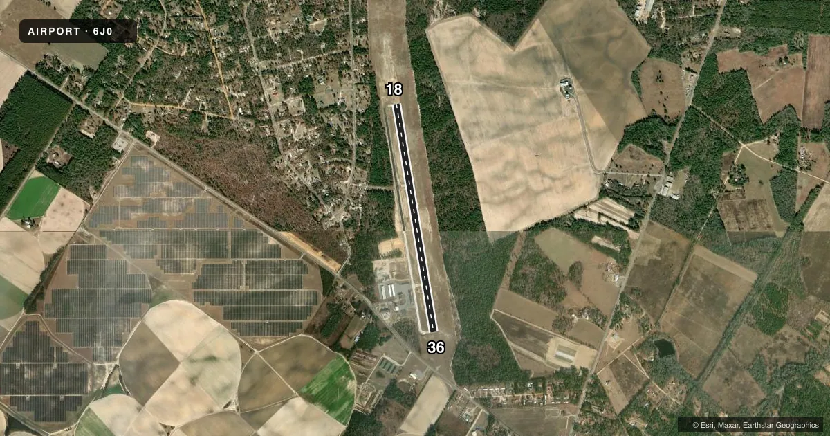
Airport sketch
Runways drawn to scale from FAA survey coordinates, rendered over satellite imagery. Not for navigation.
Approaches & charts
Services on the field
Fuel grades, oxygen, maintenance, ramp storage and lighting — as declared to the FAA by the airport operator.
Fuel & services
- Fuel
- 100LL
- Oxygen (bottled)
- Not available
- Oxygen (bulk)
- Not available
- Airframe repair
- Not available
- Power plant repair
- Not available
Ramp & ground
- Transient storage
- Tie-down
- Landing fee
- No fee published
- Lighting schedule
- SEE RMK
- Beacon schedule
- SS-SR
- Beacon
- White / Green (civil land)(WG)
- Wind indicator
- Lighted
- Segmented circle
- Yes
Fuel & FBOs
Cheapest 100LL and Jet A on the field and nearby. Always confirm with the FBO before taxi.
Airport notes
Surface conditions, obstructions, local procedures, lighting outages and other notes published with each FAA cycle.
General notes
- PLINE 800 FT FROM THLD RWY END 36; MKD WITH RED BALLS.
- ACES INTO TRML BLDG, USE THE KEY PAD AND ENTER THE UNICOM FREQ.
- FOR CD CTC COLUMBIA APCH AT 803-822-5242 OR 803-822-5040.
Lighting notes
- ACTVT PAPI RWY 36; MIRL RWY 18/36 - CTAF.
Other notes
- VFR USE ONLY.
VFR map & nearby airports
VFR sectional. Tap any ICAO chip to open that airport.
Key facts · 6J0
Answer card- ICAO
- 6J0
- Name
- LEXINGTON COUNTY
- Location
- PELION, SOUTH CAROLINA
- Elevation
- 451.7 ft MSL
- Traffic pattern altitude
- 1,451.7 ft MSL (1,000 AGL)
- Control tower
- Non-towered (use CTAF)
- Total runways
- 1
- Longest runway
- 18/36 · 4,335 ft
- Published ILS approaches
- 0
- Published frequencies
- 4
- Magnetic variation
- 7°
- Current flight rules
- VFR
- Current wind
- 080° at 3 kt
- Favored runway now
- RWY 36
Lexington County Airport sits in Pelion, South Carolina. Field elevation is 451.7 ft MSL. The airport has one runway. Runway 18/36 is 4,335 ft long with concrete pavement. There is no control tower. CTAF and UNICOM are both 123.0. Approach and departure service is through Columbia on 124.15 and 338.2.
No ILS approaches are published here. The field is listed for VFR use only. Pattern altitude is not published, so use the standard 1,000 ft AGL for light piston traffic unless ATC or the Chart Supplement says otherwise. The on-field FBO is Lexington County Airport. It carries 100LL. Call (803) 785-8100 before you go if you need current service details.
A few remarks matter for planning. There is a power line about 800 ft from the threshold of runway 36. It is marked with red balls. The PAPI is active for runway 36. Medium intensity runway lights are on runway 18/36 and are controlled by CTAF. If you need clearance delivery, contact Columbia Approach at the published phone numbers before departure. Access to the terminal building requires the keypad and the UNICOM frequency. For a first visit, brief the runway 36 departure carefully and verify the lighting and access details before arrival.