METAR & TAF 6J6
6J6 does not publish a METAR.
Showing the nearest reporting station: KAIK (AIKEN RGNL) · 8.5 NM away. Conditions at 6J6 may differ.
METAR · KAIK
Observed 21:35Z
KAIK 262135Z AUTO 29004KT 10SM CLR 32/23 A2988 RMK AO2 T03170234
- Wind
- 290° @ 4 kt
- Visibility
- 10 SM
- Temp / Dew
- 32°C / 23°C
- Altimeter
- 29.88 inHg
- Clouds
- CLR
- Density alt
- 2,847 ft
- Ceiling
- Unlimited
- Rules
- VFR
Airport info & contacts
Manager on record, flight service, ARTCC, attendance schedule and pattern altitude — published by the FAA and refreshed every 28 days.
Location
- From city
- 1 NM SE
- VFR sectional
- CHARLOTTE
- ARTCC
- ZTL · ATLANTA
- NOTAM facility
- AND (NOTAM-D)
Airport manager
- Name
- TYLER FLOM
- Phone
- 218-686-7746
- Address
- PO BOX 237, 215 JETER ST, TRENTON SC 29847
Flight service · Hours
- FSS AND
- ANDERSON1-800-WX-BRIEF
- Attendance
- Unattended
Frequencies
Tap any row to copy the frequency to your clipboard.
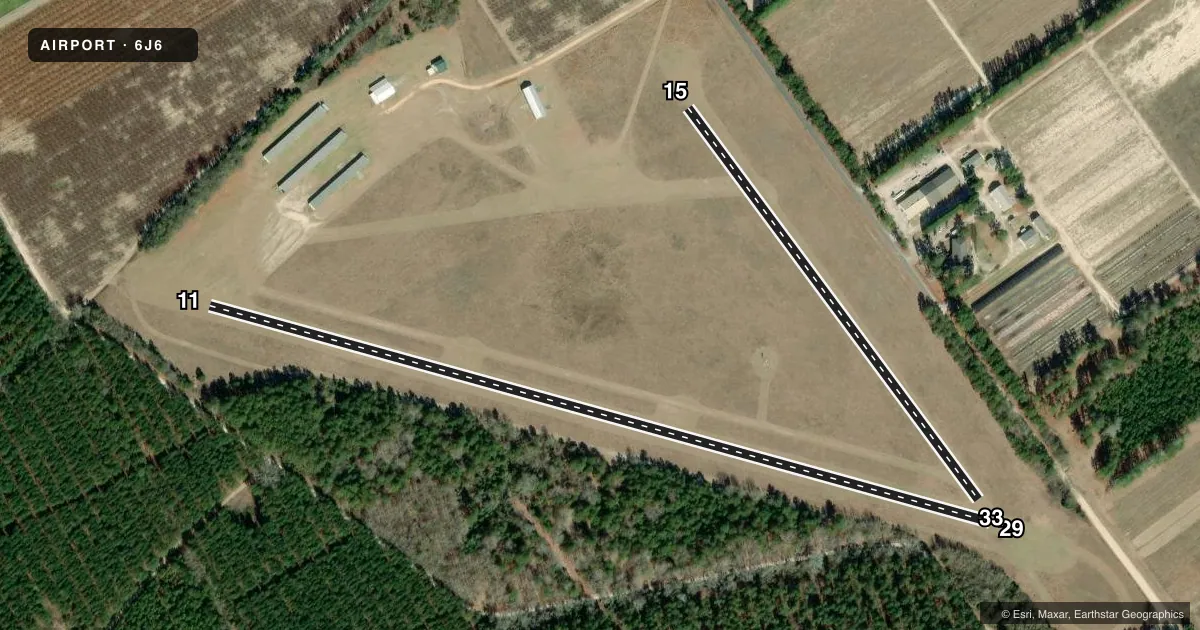
Runways & pattern
Full pagePattern entry · RWY 29
LEFT TRAFFIC| Runway | Heading (°M) | Length | Surface | Traffic |
|---|---|---|---|---|
| 11/29Favored | 101° / 281° | 2,640 ft | TURF | Standard L |
| 15/33 | 139° / 319° | 1,584 ft | TURF | Standard L |
Runway end performance
| End | TORA | TODA | ASDA | LDA | VGSI | Approach lights | Obstruction |
|---|---|---|---|---|---|---|---|
| 11 | — | — | — | — | — | — | 45', tree, 220' from thr, 119' R of cntrln, slope 4 |
| 29 | — | — | — | — | — | — | 41', tree, 468' from thr, 40' R of cntrln, slope 11 |
| 33 | — | — | — | — | — | — | 47', tree, 400' from thr, 115' R of cntrln, slope 8 |
Declared distances in feet. TORA = takeoff run available, TODA = takeoff distance, ASDA = accelerate-stop, LDA = landing distance.
Airport sketch
Runways drawn to scale from FAA survey coordinates, rendered over satellite imagery. Not for navigation.
Approaches & charts
Services on the field
Fuel grades, oxygen, maintenance, ramp storage and lighting — as declared to the FAA by the airport operator.
Fuel & services
- Fuel
- Not available
- Oxygen (bottled)
- Not available
- Oxygen (bulk)
- Not available
- Airframe repair
- Not available
- Power plant repair
- Not available
Ramp & ground
- Transient storage
- Tie-down
- Landing fee
- No fee published
- Customs
- Not available
- Wind indicator
- Yes
- Segmented circle
- Yes
Fuel & FBOs
Cheapest 100LL and Jet A on the field and nearby. Always confirm with the FBO before taxi.
Airport notes
Surface conditions, obstructions, local procedures, lighting outages and other notes published with each FAA cycle.
General notes
- RADIO CTLD ACFT ON & INVOF ARPT.
- DEER ON & INVICINITY OF ARPT.
- FOR CD CTC AUGUSTA APCH AT 706-771-1777. WHEN AUGUSTA APCH CLSD, FOR CD CTC COLUMBIA APCH AT 803-822-4511.
Other notes
- ARPT EXISTED PRIOR TO 1958
VFR map & nearby airports
VFR sectional. Tap any ICAO chip to open that airport.
Key facts · 6J6
Answer card- ICAO
- 6J6
- Name
- EDGEFIELD COUNTY
- Location
- TRENTON, SOUTH CAROLINA
- Elevation
- 611 ft MSL
- Traffic pattern altitude
- 1,611 ft MSL (1,000 AGL)
- Control tower
- Non-towered (use CTAF)
- Total runways
- 2
- Longest runway
- 11/29 · 2,640 ft
- Published ILS approaches
- 0
- Published frequencies
- 1
- Magnetic variation
- 4°
- Current flight rules
- VFR
- Current wind
- 290° at 4 kt
- Favored runway now
- RWY 29
Edgefield County Airport (6J6) is in Trenton, South Carolina. The field elevation is 611 ft MSL. It has two turf runways. The longest is 11/29 at 2,640 ft. The other runway is 15/33 at 1,584 ft. There is no control tower. CTAF is 122.9.
No ILS approaches are published here. Pattern altitude is not published, so a light piston pilot should plan on the standard 1,000 ft AGL unless the current Chart Supplement says otherwise. For this field, that works out to about 1,611 ft MSL. The magnetic variation is 4°. Clearance delivery is handled by Augusta Approach when it is open. When Augusta Approach is closed, Columbia Approach handles clearance delivery. The published remarks also call out deer on and near the airport. Radio controlled aircraft are also reported in the area. Keep your scan tight on arrival and departure.
There are no on-field FBOs listed in the facts. Plan to verify services with the airport operator or the FBO directly by phone before you go. This is a turf airport with short runways, so performance planning matters. Check runway condition, wind and density altitude before committing. The airport existed before 1958, which is a reminder that local procedures and field conditions can change. Use current published data before flight.