METAR & TAF 6J4
6J4 does not publish a METAR.
Showing the nearest reporting station: KAIK (AIKEN RGNL) · 17.5 NM away. Conditions at 6J4 may differ.
METAR · KAIK
Observed 10:35Z
KAIK 271035Z AUTO 20003KT 5SM BR CLR 23/23 A2988 RMK AO2 T02300227
- Wind
- 200° @ 3 kt
- Visibility
- 5 SM
- Temp / Dew
- 23°C / 23°C
- Altimeter
- 29.88 inHg
- Clouds
- CLR
- Density alt
- 1,678 ft
- Ceiling
- Unlimited
- Rules
- MVFR
Airport info & contacts
Manager on record, flight service, ARTCC, attendance schedule and pattern altitude — published by the FAA and refreshed every 28 days.
Location
- From city
- 4 NM S
- VFR sectional
- CHARLOTTE
- ARTCC
- ZTL · ATLANTA
- NOTAM facility
- AND (NOTAM-D)
Airport manager
- Name
- JILL WARREN
- Phone
- 864-445-2529
- Address
- 111 LAW ENFORCEMENT DRIVE, SALUDA SC 29138
Flight service · Hours
- FSS AND
- ANDERSON1-800-WX-BRIEF
- Attendance
- MON-FRI · 0800-1700
- SAT · 0800-1200
Frequencies
Tap any row to copy the frequency to your clipboard.
Runways & pattern
Full pagePattern entry · RWY 19
LEFT TRAFFICRunway end performance
| End | TORA | TODA | ASDA | LDA | VGSI | Approach lights | Obstruction |
|---|---|---|---|---|---|---|---|
| 01 | — | — | — | — | PAPI 2-box left(3°) | — | 64', tree, 1891' from thr, 220' R of cntrln, slope 26 |
| 19 | — | — | — | — | PAPI 2-box left | — | 133', tree, 2362' from thr, 319' R of cntrln, slope 16 |
Declared distances in feet. TORA = takeoff run available, TODA = takeoff distance, ASDA = accelerate-stop, LDA = landing distance.
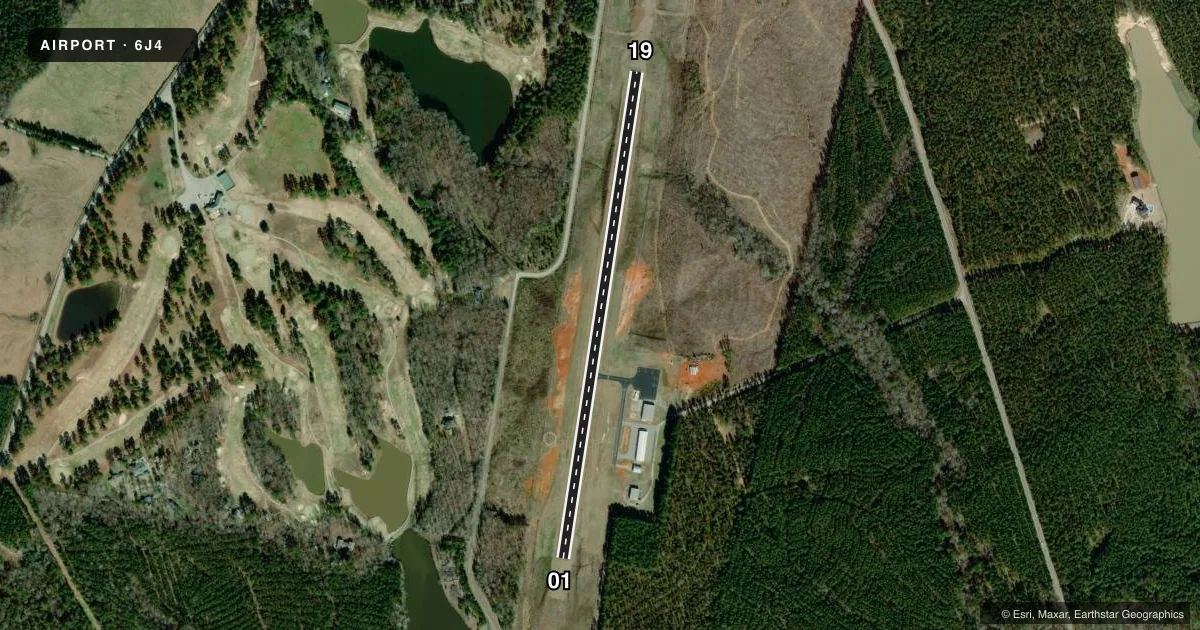
Airport sketch
Runways drawn to scale from FAA survey coordinates, rendered over satellite imagery. Not for navigation.
Approaches & charts
Services on the field
Fuel grades, oxygen, maintenance, ramp storage and lighting — as declared to the FAA by the airport operator.
Fuel & services
- Fuel
- 100LL
- Oxygen (bottled)
- Not available
- Oxygen (bulk)
- Not available
- Airframe repair
- Major
- Power plant repair
- Major
Ramp & ground
- Transient storage
- Tie-down
- Hangar
- Landing fee
- No fee published
- Customs
- Not available
- Lighting schedule
- SEE RMK
- Beacon schedule
- SS-SR
- Beacon
- White / Green (civil land)(WG)
- Wind indicator
- Lighted
- Segmented circle
- Yes
Fuel & FBOs
Cheapest 100LL and Jet A on the field and nearby. Always confirm with the FBO before taxi.
Airport notes
Surface conditions, obstructions, local procedures, lighting outages and other notes published with each FAA cycle.
General notes
- 30 FT DROP OFF N END OF RWY 01.
- FOR CD CTC AUGUSTA APCH AT 706-771-1777. WHEN AUGUSTA APCH CLSD, FOR CD CTC COLUMBIA APCH AT 803-822-4511.
Lighting notes
- ACTVT PAPI RWY 01 & 19; MIRL RWY 01/19 - CTAF.
Other notes
- VFR OPNS ONLY
VFR map & nearby airports
VFR sectional. Tap any ICAO chip to open that airport.
Key facts · 6J4
Answer card- ICAO
- 6J4
- Name
- SALUDA COUNTY
- Location
- SALUDA, SOUTH CAROLINA
- Elevation
- 539.2 ft MSL
- Traffic pattern altitude
- 1,539.2 ft MSL (1,000 AGL)
- Control tower
- Non-towered (use CTAF)
- Total runways
- 1
- Longest runway
- 01/19 · 3,189 ft
- Published ILS approaches
- 0
- Published frequencies
- 4
- Magnetic variation
- 6°
- Current flight rules
- MVFR
- Current wind
- 200° at 3 kt
- Favored runway now
- RWY 19
Saluda County Airport sits in Saluda, South Carolina. The field elevation is 539.2 ft MSL. It has one runway. Runway 01/19 is 3,189 ft long with asphalt pavement. The airport is not towered. CTAF is 122.9. Augusta Approach handles clearance delivery. When Augusta Approach is closed, Columbia Approach handles clearance delivery.
No ILS approaches are published here. The published pattern altitude is not listed, so use the standard 1,000 ft AGL for light piston traffic unless the current Chart Supplement says otherwise. The airport is VFR operations only. That matters if you are planning an IFR arrival or departure. Check the current Chart Supplement before you go.
Saluda County Airport has one on-field FBO. Saluda County Airport carries 100LL. PAPI is active on runways 01 and 19. Medium intensity runway lights are also on 01 and 19. They are controlled by CTAF. There is a 30 ft drop off at the north end of runway 01, so brief that end carefully on rollout and departure. The field sits in a non-towered environment with a short single runway, so expect normal self-announce traffic discipline and keep an eye on runway length when planning performance.