METAR & TAF KEOE
Current METAR
Observed 07:35Z
KEOE 270735Z AUTO 00000KT 5SM BR CLR 23/22 A2990 RMK AO2
- Wind
- 000° @ 0 kt
- Visibility
- 5 SM
- Temp / Dew
- 23°C / 22°C
- Altimeter
- 29.90 inHg
- Clouds
- CLR
- Density alt
- 1,692 ft
- Ceiling
- Unlimited
- Rules
- MVFR
Airport info & contacts
Manager on record, flight service, ARTCC, attendance schedule and pattern altitude — published by the FAA and refreshed every 28 days.
Location
- From city
- 3 NM N
- VFR sectional
- CHARLOTTE
- ARTCC
- ZJX · JACKSONVILLE
- NOTAM facility
- AND (NOTAM-D)
Airport manager
- Name
- JOSH ROWE
- Phone
- 803-944-0613
- Address
- P.O. BOX 156, 1309 COLLEGE STREET, NEWBERRY SC 29108
Flight service · Hours
- FSS AND
- ANDERSON1-800-WX-BRIEF
- Attendance
- Unattended
Frequencies
Tap any row to copy the frequency to your clipboard.
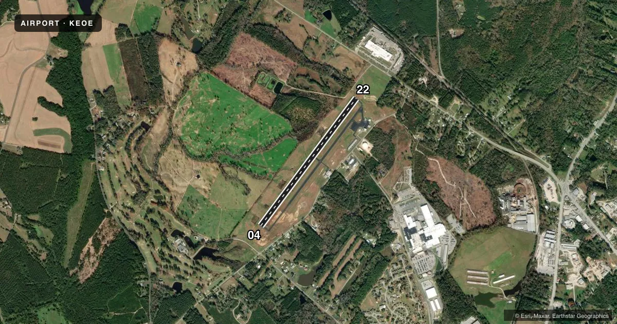
Runways & pattern
Full pagePattern entry · RWY 04
LEFT TRAFFICRunway end performance
| End | TORA | TODA | ASDA | LDA | VGSI | Approach lights | Obstruction |
|---|---|---|---|---|---|---|---|
| 04 | — | — | — | — | PAPI 2-box left(3.15°) | — | 96', trees, 2379' from thr, 271' R of cntrln, slope 22 |
| 22 | — | — | — | — | PAPI 2-box left(3.15°) | — | 62', tree, 1720' from thr, 40' R of cntrln, slope 24 |
Declared distances in feet. TORA = takeoff run available, TODA = takeoff distance, ASDA = accelerate-stop, LDA = landing distance.
Airport sketch
Runways drawn to scale from FAA survey coordinates, rendered over satellite imagery. Not for navigation.
Approaches & charts
Services on the field
Fuel grades, oxygen, maintenance, ramp storage and lighting — as declared to the FAA by the airport operator.
Fuel & services
- Fuel
- 100LL
- Oxygen (bottled)
- Not available
- Oxygen (bulk)
- Not available
- Airframe repair
- Major
- Power plant repair
- Major
- Other services
- INSTR
Ramp & ground
- Transient storage
- Tie-down
- Landing fee
- No fee published
- Customs
- Not available
- Lighting schedule
- SEE RMK
- Beacon schedule
- SS-SR
- Beacon
- White / Green (civil land)(WG)
- Wind indicator
- Lighted
- Segmented circle
- Yes
Fuel & FBOs
Cheapest 100LL and Jet A on the field and nearby. Always confirm with the FBO before taxi.
Airport notes
Surface conditions, obstructions, local procedures, lighting outages and other notes published with each FAA cycle.
General notes
- DEER ON & INVOF ARPT.
- FOR CD CTC COLUMBIA APCH AT 803-822-4511.
Lighting notes
- ACTVT PAPI RWY 22; MIRL RWY 04/22 - CTAF. PAPI RWY 04 OPER CONSLY.
Fuel notes
- 100LLSELF-SERVE.
Other notes
- EXISTED PRIOR TO 1958.
- MANAGERPUB WORKS DIR.
- MANAGER(803) 321-2383 FAX.
VFR map & nearby airports
VFR sectional. Tap any ICAO chip to open that airport.
Key facts · KEOE
Answer card- ICAO
- KEOE
- Name
- NEWBERRY COUNTY
- Location
- NEWBERRY, SOUTH CAROLINA
- Elevation
- 570.1 ft MSL
- Traffic pattern altitude
- 1,570.1 ft MSL (1,000 AGL)
- Control tower
- Non-towered (use CTAF)
- Total runways
- 1
- Longest runway
- 04/22 · 4,001 ft
- Published ILS approaches
- 0
- Published frequencies
- 4
- Magnetic variation
- 7°
- Current flight rules
- MVFR
- Current wind
- 000° at 0 kt
- Favored runway now
- –
Newberry County Airport sits in Newberry, South Carolina. Field elevation is 570.1 ft MSL. The airport has one runway, 04/22, which is 4,001 ft asphalt. There is no control tower. CTAF and UNICOM are both 122.8. Approach and departure service is handled by Columbia on 133.4 or 285.6. No ILS approaches are published here.
Pattern altitude is not published. Use 1,000 ft AGL as the standard light-piston reference unless the current Chart Supplement says otherwise. The field has one on-field FBO, Newberry County Airport Commision. It carries 100LL. Self-serve 100LL is published. For clearance delivery, contact Columbia Approach at 803-822-4511.
A few operational notes matter here. Deer are reported on and near the airport. Keep a sharp scan on taxi, takeoff and landing. Runway lights on 04/22 are medium intensity and controlled by CTAF. PAPI on runway 22 is activated. PAPI on runway 04 operates continuously. The airport is in a non-towered environment, so standard CTAF discipline matters. Check the current FAA Chart Supplement for any updated remarks before you go. The airport sits at a modest elevation, so density altitude is usually not the main issue. Local traffic, wildlife and lighting setup are the bigger items to brief.