METAR & TAF KLUX
Current METAR
Observed 10:35Z
KLUX 271035Z AUTO 00000KT 5SM BR CLR 23/22 A2987 RMK AO2
- Wind
- 000° @ 0 kt
- Visibility
- 5 SM
- Temp / Dew
- 23°C / 22°C
- Altimeter
- 29.87 inHg
- Clouds
- CLR
- Density alt
- 1,887 ft
- Ceiling
- Unlimited
- Rules
- MVFR
Airport info & contacts
Manager on record, flight service, ARTCC, attendance schedule and pattern altitude — published by the FAA and refreshed every 28 days.
Location
- From city
- 3 NM E
- VFR sectional
- ATLANTA
- Pattern altitude
- 803 ft AGL · 1,501 ft MSL
- ARTCC
- ZTL · ATLANTA
- NOTAM facility
- AND (NOTAM-D)
Airport manager
- Name
- GIFFORD A. BOYTER
- Phone
- (864) 923-3507
- Address
- 3985 TORRINGTON ROAD, LAURENS SC 29360
Flight service · Hours
- FSS AND
- ANDERSON1-800-WX-BRIEF
- Attendance
- MON-SAT · 0900-1700
- SUN · 1300-1700
Frequencies
Tap any row to copy the frequency to your clipboard.
Runways & pattern
Full pagePattern entry · RWY 08
LEFT TRAFFICRunway end performance
| End | TORA | TODA | ASDA | LDA | VGSI | Approach lights | Obstruction |
|---|---|---|---|---|---|---|---|
| 08 | — | — | — | — | PAPI 2-box left(3°) | — | 52', tree, 1002' from thr, 113' R of cntrln, slope 15 |
| 26 | — | — | — | — | PAPI 2-box left(3.25°) | — | 56', tree, 1059' from thr, 144' R of cntrln, slope 15 |
Declared distances in feet. TORA = takeoff run available, TODA = takeoff distance, ASDA = accelerate-stop, LDA = landing distance.
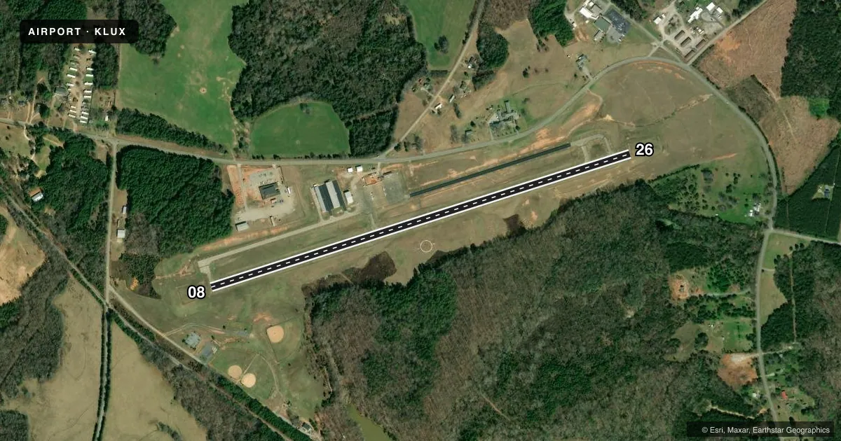
Airport sketch
Runways drawn to scale from FAA survey coordinates, rendered over satellite imagery. Not for navigation.
Approaches & charts
Services on the field
Fuel grades, oxygen, maintenance, ramp storage and lighting — as declared to the FAA by the airport operator.
Fuel & services
- Fuel
- 100LL
- Oxygen (bottled)
- Not available
- Oxygen (bulk)
- Not available
- Airframe repair
- Major
- Power plant repair
- Major
- Other services
- INSTR
Ramp & ground
- Transient storage
- Tie-down
- Landing fee
- No fee published
- Customs
- Not available
- Lighting schedule
- SEE RMK
- Beacon schedule
- SS-SR
- Beacon
- White / Green (civil land)(WG)
- Wind indicator
- Lighted
- Segmented circle
- Yes
Fuel & FBOs
Cheapest 100LL and Jet A on the field and nearby. Always confirm with the FBO before taxi.
Airport notes
Surface conditions, obstructions, local procedures, lighting outages and other notes published with each FAA cycle.
General notes
- FOR CD CTC GREER APCH AT 864-877-8275. WHEN GREER APCH CLSD, FOR CD CTC ATLANTA ARTCC AT 770-210-7692.
Lighting notes
- ACTVT REIL RWY 08 & 26; MIRL RWY 08/26 - CTAF. PAPI RWY 08 & 26 OPR CONSLY.
Fuel notes
- 100LLSELF SVC 24 HR FUEL WITH CREDIT CARD.
Other notes
- TPA: 803 FT AGL.
VFR map & nearby airports
VFR sectional. Tap any ICAO chip to open that airport.
Key facts · KLUX
Answer card- ICAO
- KLUX
- Name
- LAURENS COUNTY
- Location
- LAURENS, SOUTH CAROLINA
- Elevation
- 697.6 ft MSL
- Traffic pattern altitude
- 1,500.6 ft MSL (803 AGL)
- Control tower
- Non-towered (use CTAF)
- Total runways
- 1
- Longest runway
- 08/26 · 4,051 ft
- Published ILS approaches
- 0
- Published frequencies
- 4
- Magnetic variation
- 7°
- Current flight rules
- MVFR
- Current wind
- 000° at 0 kt
- Favored runway now
- –
Laurens County Airport sits in Laurens, South Carolina. Field elevation is 697.6 ft MSL. The airport has one runway. Runway 08/26 is 4,051 ft long with a concrete surface. The field is not towered. Traffic pattern altitude is 803 ft AGL, which is 1,500.6 ft MSL.
No ILS approaches are published here. Runway end identifier lights are active on 08 and 26. Medium intensity runway lights are also on 08 and 26. They are controlled by CTAF. Precision approach path indicators operate continuously on both runway ends. Self-service 24-hour fuel is available with a credit card. The on-field FBO is Laurens County Airport. It carries AVGAS 100LL. Call (864) 682-9620 for current service details.
For IFR clearance delivery, contact Greer Approach at 864-877-8275. When Greer Approach is closed, use Atlanta ARTCC at 770-210-7692. Pilots should also check the current FAA Chart Supplement for any noise or operating notes before departure. With a single 4,051 ft runway and no published ILS, plan conservatively if the weather is marginal or the field is busy.