METAR & TAF KGRD
Current METAR
Observed 17:56Z
KGRD 261756Z AUTO VRB03KT 10SM FEW030 29/23 A2996 RMK AO2 SLP138 60000 T02890233 10294 20244 58012
- Wind
- VAR @ 3 kt
- Visibility
- 10 SM
- Temp / Dew
- 29°C / 23°C
- Altimeter
- 29.96 inHg
- Clouds
- FEW
- Density alt
- 2,413 ft
- Ceiling
- Unlimited
- Rules
- VFR
Airport info & contacts
Manager on record, flight service, ARTCC, attendance schedule and pattern altitude — published by the FAA and refreshed every 28 days.
Location
- From city
- 3 NM N
- VFR sectional
- ATLANTA
- ARTCC
- ZTL · ATLANTA
- NOTAM facility
- GRD (NOTAM-D)
Airport manager
- Name
- RETT TEMPLETON
- Phone
- (864) 942-8556
- Address
- 528 MONUMENT STREET, ROOM B-03, GREENWOOD SC 29649
Flight service · Hours
- FSS AND
- ANDERSON1-800-WX-BRIEF
- Attendance
- MON-FRI · 0730-1800
- SUN · 1100-1700
- SAT · 0800-1700
Frequencies
Tap any row to copy the frequency to your clipboard.
Runways & pattern
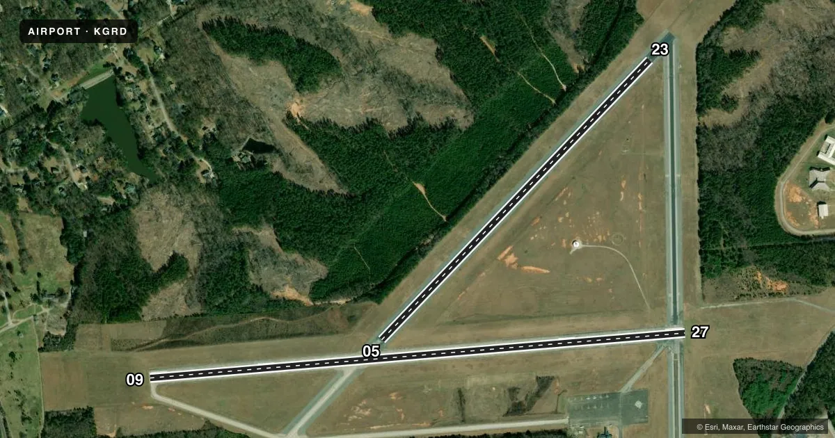
Full pagePattern entry · RWY 05
LEFT TRAFFIC| Runway | Heading (°M) | Length | Surface | Traffic |
|---|---|---|---|---|
| 09/27 | 78° / 258° | 5,001 ft | CONC | Standard L |
| 05/23Favored | 37° / 217° | 3,600 ft | ASPH | Standard L |
Runway end performance
| End | TORA | TODA | ASDA | LDA | VGSI | Approach lights | Obstruction |
|---|---|---|---|---|---|---|---|
| 09 | — | — | — | — | PAPI 2-box left(3°) | — | 45', tree, 1223' from thr, 32' R of cntrln, slope 22 |
| 27 | — | — | — | — | PAPI 2-box left(3°) | ODALS | 49', tree, 1614' from thr, 71' R of cntrln, slope 28 |
| 05 | — | — | — | — | — | — | 50', tree, 1865' from thr, 248' R of cntrln, slope 33 |
| 23 | — | — | — | — | — | — | 66', tree, 1472' from thr, 119' R of cntrln, slope 19 |
Declared distances in feet. TORA = takeoff run available, TODA = takeoff distance, ASDA = accelerate-stop, LDA = landing distance.
Airport sketch
Runways drawn to scale from FAA survey coordinates, rendered over satellite imagery. Not for navigation.
Approaches & charts
Services on the field
Fuel grades, oxygen, maintenance, ramp storage and lighting — as declared to the FAA by the airport operator.
Fuel & services
- Fuel
- 100LLA
- Oxygen (bottled)
- Not available
- Oxygen (bulk)
- Not available
- Airframe repair
- Major
- Power plant repair
- Minor
- Other services
- CHTR,INSTR,RNTL
Ramp & ground
- Transient storage
- Tie-down
- Landing fee
- No fee published
- Customs
- Not available
- Lighting schedule
- SEE RMK
- Beacon schedule
- SS-SR
- Beacon
- White / Green (civil land)(WG)
- Wind indicator
- Lighted
- Segmented circle
- Yes
Fuel & FBOs
Cheapest 100LL and Jet A on the field and nearby. Always confirm with the FBO before taxi.
Airport notes
Surface conditions, obstructions, local procedures, lighting outages and other notes published with each FAA cycle.
General notes
- TWY A PARALLEL TO RY 09/27; DROPOFFS EACH SIDE OF TWY BEYOND SHOULDER.
- FOR CD IF UNA TO CTC ON FSS FREQ, CTC GREER APCH AT 864-877-8275, WHEN APCH CLSD CTC ATLANTA ARTCC AT 770-210-7692.
Lighting notes
- MIRL RY 09/27 PRESET ON MED INTST DUSK-2300; TO INCR INTST & ACTVT REIL RYS 09 & 27 - CTAF. AFTER 2300, ACTVT MIRL RY 09/27, REIL RYS 09 & 27 AND ODALS RY 27 - CTAF.
Other notes
- ARPT EXISTED PRIOR 1958
- MANAGERFBO PHONE 864-942-9634
VFR map & nearby airports
VFR sectional. Tap any ICAO chip to open that airport.
Key facts · KGRD
Answer card- ICAO
- KGRD
- Name
- GREENWOOD COUNTY
- Location
- GREENWOOD, SOUTH CAROLINA
- Elevation
- 631.2 ft MSL
- Traffic pattern altitude
- 1,631.2 ft MSL (1,000 AGL)
- Control tower
- Non-towered (use CTAF)
- Total runways
- 2
- Longest runway
- 09/27 · 5,001 ft
- Published ILS approaches
- 0
- Published frequencies
- 4
- Magnetic variation
- 7°
- Current flight rules
- VFR
- Current wind
- 000° at 3 kt
- Favored runway now
- RWY 05
Greenwood County Airport sits in Greenwood, South Carolina. Field elevation is 631.2 ft MSL. The airport has two runways. The longest is runway 09/27 at 5,001 ft. There is no control tower. No ILS approaches are published. Pattern altitude is not published, so a light piston pilot should plan for the standard 1,000 ft AGL pattern unless the current Chart Supplement says otherwise.
Aeronautical Services of Greenwood is on the field. It carries 100LL and Jet A. Call the FBO directly at (864) 942-9634 before arrival for current services. Taxiway A runs parallel to runway 09/27. The published remarks also note dropoffs on both sides of the taxiway beyond the shoulder, so taxi with care.
Runway 09/27 has medium intensity lighting that is preset from dusk to 2300. After 2300, the lights on 09/27, the runway end identifier lights on 09 and 27, plus the omnidirectional approach lighting system on runway 27 are activated through the CTAF. The field is in the Greer approach area for IFR handling. If you need clearance delivery help, use the published contact numbers in the current Chart Supplement. For a first trip, the main things to watch are the taxiway edge dropoffs, the lighting procedure after dark and the lack of published ILS support.