METAR & TAF S19
S19 does not publish a METAR.
Showing the nearest reporting station: KGRD (GREENWOOD COUNTY) · 21.3 NM away. Conditions at S19 may differ.
METAR · KGRD
Observed 11:56Z
KGRD 271156Z AUTO 30003KT 7SM SCT120 24/24 A2990 RMK AO2 SLP117 T02440239 10250 20233 53007
- Wind
- 300° @ 3 kt
- Visibility
- 7 SM
- Temp / Dew
- 24°C / 24°C
- Altimeter
- 29.90 inHg
- Clouds
- SCT
- Density alt
- 1,674 ft
- Ceiling
- Unlimited
- Rules
- VFR
Airport info & contacts
Manager on record, flight service, ARTCC, attendance schedule and pattern altitude — published by the FAA and refreshed every 28 days.
Location
- From city
- 1 NM SE
- VFR sectional
- ATLANTA
- ARTCC
- ZTL · ATLANTA
- NOTAM facility
- AND (NOTAM-D)
Airport manager
- Name
- MARK WARNER
- Phone
- 864-602-9082
- Address
- 610 S. MINE STREET, MC CORMICK SC 29835
Flight service · Hours
- FSS AND
- ANDERSON1-800-WX-BRIEF
- Attendance
- Unattended
Frequencies
Tap any row to copy the frequency to your clipboard.
Runways & pattern
Full pagePattern entry · RWY 36
RIGHT TRAFFICRunway end performance
| End | TORA | TODA | ASDA | LDA | VGSI | Approach lights | Obstruction |
|---|---|---|---|---|---|---|---|
| 18 | — | — | — | — | — | — | 32', tree, 766' from thr, 110' R of cntrln, slope 17 |
| 36 | — | — | — | — | — | — | 70', tree, 1062' from thr, 174' R of cntrln, slope 12 |
Declared distances in feet. TORA = takeoff run available, TODA = takeoff distance, ASDA = accelerate-stop, LDA = landing distance.
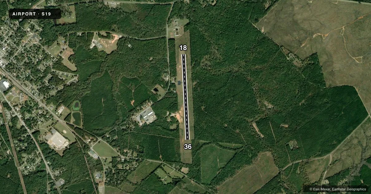
Airport sketch
Runways drawn to scale from FAA survey coordinates, rendered over satellite imagery. Not for navigation.
Approaches & charts
Services on the field
Fuel grades, oxygen, maintenance, ramp storage and lighting — as declared to the FAA by the airport operator.
Fuel & services
- Fuel
- Not available
- Oxygen (bottled)
- Not available
- Oxygen (bulk)
- Not available
- Airframe repair
- Not available
- Power plant repair
- Not available
Ramp & ground
- Transient storage
- Tie-down
- Landing fee
- No fee published
- Beacon schedule
- SEE RMK
- Beacon
- White / Green (civil land)(WG)
- Wind indicator
- Yes
- Segmented circle
- Yes
Fuel & FBOs
Cheapest 100LL and Jet A on the field and nearby. Always confirm with the FBO before taxi.
Airport notes
Surface conditions, obstructions, local procedures, lighting outages and other notes published with each FAA cycle.
General notes
- NO NGT OPS.
- FOR CD CTC AUGUSTA APCH AT 706-771-1777. WHEN AUGUSTA APCH CLSD, FOR CD CTC ATLANTA ARTCC AT 770-210-7692.
Lighting notes
- BCN O/S.
- BCN O/S.
Approach & departure obstructions
- 18TRRN 15 FT HYR THAN RWY THLD 82 FT L OF CNTRLN.
Other notes
- ALL OPS ARE CONDUCTED IN VFR WX CONDS.
- MANAGERCOUNTY ADMIR.
VFR map & nearby airports
VFR sectional. Tap any ICAO chip to open that airport.
Key facts · S19
Answer card- ICAO
- S19
- Name
- MC CORMICK COUNTY
- Location
- MC CORMICK, SOUTH CAROLINA
- Elevation
- 459.4 ft MSL
- Traffic pattern altitude
- 1,459.4 ft MSL (1,000 AGL)
- Control tower
- Non-towered (use CTAF)
- Total runways
- 1
- Longest runway
- 18/36 · 3,598 ft
- Published ILS approaches
- 0
- Published frequencies
- 1
- Magnetic variation
- 4°
- Current flight rules
- VFR
- Current wind
- 300° at 3 kt
- Favored runway now
- RWY 36
Mc Cormick County Airport sits in Mc Cormick, South Carolina. Field elevation is 459.4 ft MSL. The airport has one runway. Runway 18/36 is 3,598 ft of asphalt. There is no control tower. CTAF is 122.9. No ILS approaches are published here.
Pattern altitude is not published. Use the standard 1,000 ft AGL for light piston operations unless the current Chart Supplement says otherwise. The published remarks also say no night operations are permitted. All operations are conducted in VFR weather conditions. The airport beacon is out of service, so plan your arrival with that in mind if you are used to using beacon lighting as a reference.
For clearance delivery, contact Augusta Approach at 706-771-1777. When Augusta Approach is closed, contact Atlanta ARTCC at 770-210-7692. There are no on-field FBOs listed, so verify fuel and service availability with the airport operator or call the field directly before you go. One published note also calls out terrain near the runway 18 end, with higher ground left of the centerline. That is worth keeping in mind on departure and arrival, especially if you are operating a light aircraft in marginal conditions.