METAR & TAF KIIY
Current METAR
Observed 13:35Z
KIIY 271335Z AUTO 31004KT 10SM CLR 27/24 A2990 RMK AO2 T02730240
- Wind
- 310° @ 4 kt
- Visibility
- 10 SM
- Temp / Dew
- 27°C / 24°C
- Altimeter
- 29.90 inHg
- Clouds
- CLR
- Density alt
- 2,266 ft
- Ceiling
- Unlimited
- Rules
- VFR
Airport info & contacts
Manager on record, flight service, ARTCC, attendance schedule and pattern altitude — published by the FAA and refreshed every 28 days.
Location
- From city
- 4 NM NW
- VFR sectional
- ATLANTA
- ARTCC
- ZTL · ATLANTA
- NOTAM facility
- IIY (NOTAM-D)
Airport manager
- Name
- DANN STANDARD
- Phone
- 706-836-0442
- Address
- 351 AIRPORT ROAD, WASHINGTON GA 30673
Flight service · Hours
- FSS MCN
- MACON1-800-WX-BRIEF
- Attendance
- VARIABLE
Frequencies
Tap any row to copy the frequency to your clipboard.
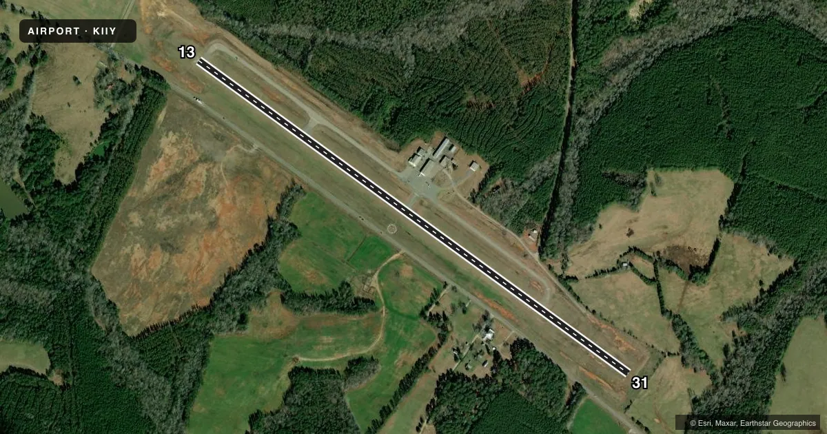
Runways & pattern
Full pagePattern entry · RWY 31
LEFT TRAFFICRunway end performance
| End | TORA | TODA | ASDA | LDA | VGSI | Approach lights | Obstruction |
|---|---|---|---|---|---|---|---|
| 13 | — | — | — | — | PAPI 2-box left(3°) | — | 29', road, 780' from thr, 241' R of cntrln, slope 20 |
| 31 | — | — | — | — | PAPI 2-box left(3°) | — | 65', trees, 785' from thr, 219' R of cntrln, slope 9 |
Declared distances in feet. TORA = takeoff run available, TODA = takeoff distance, ASDA = accelerate-stop, LDA = landing distance.
Airport sketch
Runways drawn to scale from FAA survey coordinates, rendered over satellite imagery. Not for navigation.
Approaches & charts
Services on the field
Fuel grades, oxygen, maintenance, ramp storage and lighting — as declared to the FAA by the airport operator.
Fuel & services
- Fuel
- 100LLA+
- Oxygen (bottled)
- Not available
- Oxygen (bulk)
- Not available
- Airframe repair
- Not available
- Power plant repair
- Not available
Ramp & ground
- Transient storage
- Tie-down
- Landing fee
- No fee published
- Customs
- Not available
- Lighting schedule
- SEE RMK
- Beacon schedule
- SS-SR
- Beacon
- White / Green (civil land)(WG)
- Wind indicator
- Lighted
- Segmented circle
- Yes
Fuel & FBOs
Cheapest 100LL and Jet A on the field and nearby. Always confirm with the FBO before taxi.
Airport notes
Surface conditions, obstructions, local procedures, lighting outages and other notes published with each FAA cycle.
General notes
- FOR CD CTC AUGUSTA APCH AT 706-771-1777, WHEN APCH CLSD CTC ATLANTA ARTCC AT 770-210-7692.
Lighting notes
- ACTVT REILS RWY 13 & 31; PAPI RWY 13 & 31; MIRL RWY 13/31 - CTAF.
Approach & departure obstructions
- 13HIGH GROUND 205FT R OF CNTRLN.
- 31HIGH GROUND 205FT L OF CNTRLN.
Other notes
- 1ON CALL - 706-836-0442
VFR map & nearby airports
VFR sectional. Tap any ICAO chip to open that airport.
Key facts · KIIY
Answer card- ICAO
- KIIY
- Name
- WASHINGTON/WILKES COUNTY
- Location
- WASHINGTON, GEORGIA
- Elevation
- 646.1 ft MSL
- Traffic pattern altitude
- 1,646.1 ft MSL (1,000 AGL)
- Control tower
- Non-towered (use CTAF)
- Total runways
- 1
- Longest runway
- 13/31 · 5,020 ft
- Published ILS approaches
- 0
- Published frequencies
- 4
- Magnetic variation
- 7°
- Current flight rules
- VFR
- Current wind
- 310° at 4 kt
- Favored runway now
- RWY 31
Washington/Wilkes County Airport sits in Washington, Georgia. Field elevation is 646.1 ft MSL. The airport has one runway, 13/31, at 5,020 ft of asphalt. There is no control tower. No ILS approaches are published here. The pattern altitude is not published, so use the standard 1,000 ft AGL for light piston traffic unless the current Chart Supplement says otherwise.
The on-field FBO is Washington/Wilkes County Airport. It carries AVGAS 100LL and Jet A Prist. Call (706) 836-0442 for current service status before you go. Published remarks note runway end identifier lights and PAPI on both ends of 13/31. Medium intensity runway lights are on runway 13/31 and are controlled by CTAF. That makes night ops more straightforward, but you still need to verify current lighting procedures before departure.
Pay attention to the terrain near both runway ends. The Chart Supplement notes high ground 205 feet right of centerline on runway 13. It also notes high ground 205 feet left of centerline on runway 31. Clearance delivery is through Augusta Approach when it is open. When Augusta Approach is closed, contact Atlanta ARTCC. For a first-time arrival, review the current Chart Supplement and be ready for a non-towered field with nearby terrain and no published ILS.