METAR & TAF 52A
52A does not publish a METAR.
Showing the nearest reporting station: KCPP (GREENE COUNTY RGNL) · 16.1 NM away. Conditions at 52A may differ.
METAR · KCPP
Observed 13:15Z
KCPP 271315Z AUTO 00000KT 8SM CLR 27/24 A2990 RMK AO2
- Wind
- 000° @ 0 kt
- Visibility
- 8 SM
- Temp / Dew
- 27°C / 24°C
- Altimeter
- 29.90 inHg
- Clouds
- CLR
- Density alt
- 2,325 ft
- Ceiling
- Unlimited
- Rules
- VFR
Airport info & contacts
Manager on record, flight service, ARTCC, attendance schedule and pattern altitude — published by the FAA and refreshed every 28 days.
Location
- From city
- 2 NM NE
- VFR sectional
- ATLANTA
- ARTCC
- ZTL · ATLANTA
- NOTAM facility
- MCN (NOTAM-D)
Airport manager
- Name
- JOHN KLIMM
- Phone
- 706-342-1251
- Address
- 132 NORTH MAIN STREET, MADISON GA 30650
Flight service · Hours
- FSS MCN
- MACON1-800-WX-BRIEF
- Attendance
- MON-SAT · 0900-1500
- SUN · 0900 - 1200
Frequencies
Tap any row to copy the frequency to your clipboard.
Runways & pattern
Full pagePattern entry · RWY 14
LEFT TRAFFICRunway end performance
| End | TORA | TODA | ASDA | LDA | VGSI | Approach lights | Obstruction |
|---|---|---|---|---|---|---|---|
| 14 | 3,806' | 3,806' | 3,740' | 3,740' | PAPI 2-box left(3°) | — | 33', trees, 215' from thr, 248' R of cntrln, slope 0 |
| 32 | 3,806' | 3,806' | 3,806' | 2,675' | — | — | 15', road, 201' from thr, 0' R of cntrln, slope 0 |
Declared distances in feet. TORA = takeoff run available, TODA = takeoff distance, ASDA = accelerate-stop, LDA = landing distance.
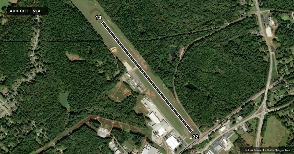
Airport sketch
Runways drawn to scale from FAA survey coordinates, rendered over satellite imagery. Not for navigation.
Approaches & charts
Services on the field
Fuel grades, oxygen, maintenance, ramp storage and lighting — as declared to the FAA by the airport operator.
Fuel & services
- Fuel
- 100LL
- Oxygen (bottled)
- Not available
- Oxygen (bulk)
- Not available
- Airframe repair
- Minor
- Power plant repair
- Minor
Ramp & ground
- Transient storage
- Tie-down
- Landing fee
- No fee published
- Customs
- Not available
- Lighting schedule
- SEE RMK
- Beacon schedule
- SS-SR
- Beacon
- White / Green (civil land)(WG)
- Wind indicator
- Lighted
- Segmented circle
- Yes
Fuel & FBOs
Cheapest 100LL and Jet A on the field and nearby. Always confirm with the FBO before taxi.
Airport notes
Surface conditions, obstructions, local procedures, lighting outages and other notes published with each FAA cycle.
General notes
- FOR CD CTC ATLANTA APCH AT 678-364-6131, WHEN APCH CLSD CTC ATLANTA ARTCC AT 770-210-7692.
Lighting notes
- ACTVT MIRL RY 14/32 & PAPI RY 14 - CTAF.
Fuel notes
- 100LLSELF SVC FUEL AVBL 24 HRS WITH CREDIT CARD.
Approach & departure obstructions
- 329 FT SECURITY FENCE CROSSES APPH 175 FT FM RY END, AND 15 FT ROAD CROSSES APCH 200 FT FROM RY END.
- 14CONTROLLING OBSTRUCTION EXCEEDS A 45 DEGREE SLOPE
- 32APCH RATIO 34:1 TO DSPLCD THR, 1530 FT FM DSPLCD THR, 200 FT RIGHT.
Other notes
- MANAGERCITY MGR
- MANAGERARPT PHONE 706-342-9857
VFR map & nearby airports
VFR sectional. Tap any ICAO chip to open that airport.
Key facts · 52A
Answer card- ICAO
- 52A
- Name
- MADISON MUNI
- Location
- MADISON, GEORGIA
- Elevation
- 694 ft MSL
- Traffic pattern altitude
- 1,694 ft MSL (1,000 AGL)
- Control tower
- Non-towered (use CTAF)
- Total runways
- 1
- Longest runway
- 14/32 · 3,806 ft
- Published ILS approaches
- 0
- Published frequencies
- 4
- Magnetic variation
- 4°
- Current flight rules
- VFR
- Current wind
- 000° at 0 kt
- Favored runway now
- –
Madison Muni sits in Madison, Georgia. The field elevation is 694 ft MSL. It has one runway, 14/32, which is 3,806 ft long. There is no control tower. Traffic uses CTAF 122.8. Pattern altitude is not published, so use the standard 1,000 ft AGL for light piston operations unless the current Chart Supplement says otherwise.
No ILS approaches are published here. Reynolds Aviation Services is on the field. It carries 100LL. Self-service fuel is available 24 hours with a credit card. The airport phone is 706-342-9857.
This is a non-towered field with Atlanta approach services on the published frequencies. The remarks also call out runway lighting on 14/32. The PAPI for runway 14 is activated by CTAF. There are obstructions near the runway 32 approach. A security fence and a road sit close in. Runway 14 also has a controlling obstruction that exceeds a 45 degree slope. That makes a careful approach planning check important before you arrive. If you need clearance delivery, contact Atlanta Approach. If approach is closed, use Atlanta ARTCC. Check the current Chart Supplement before flight for any updated operational notes.