METAR & TAF D73
Current METAR
Observed 11:55Z
KD73 271155Z AUTO 7SM CLR A2992 RMK AO2
- Wind
- Calm
- Visibility
- 7 SM
- Temp / Dew
- —
- Altimeter
- 29.92 inHg
- Clouds
- CLR
- Density alt
- —
- Ceiling
- Unlimited
- Rules
- VFR
Airport info & contacts
Manager on record, flight service, ARTCC, attendance schedule and pattern altitude — published by the FAA and refreshed every 28 days.
Location
- From city
- 1 NM SE
- VFR sectional
- ATLANTA
- ARTCC
- ZTL · ATLANTA
- NOTAM facility
- MCN (NOTAM-D)
Airport manager
- Name
- CHRIS CROY
- Phone
- 770-266-5172
- Address
- 215 NORTH BROAD STREET, MONROE GA 30655
Flight service · Hours
- FSS MCN
- MACON1-800-WX-BRIEF
- Attendance
- MON-FRI · 0700-1700
Frequencies
Tap any row to copy the frequency to your clipboard.
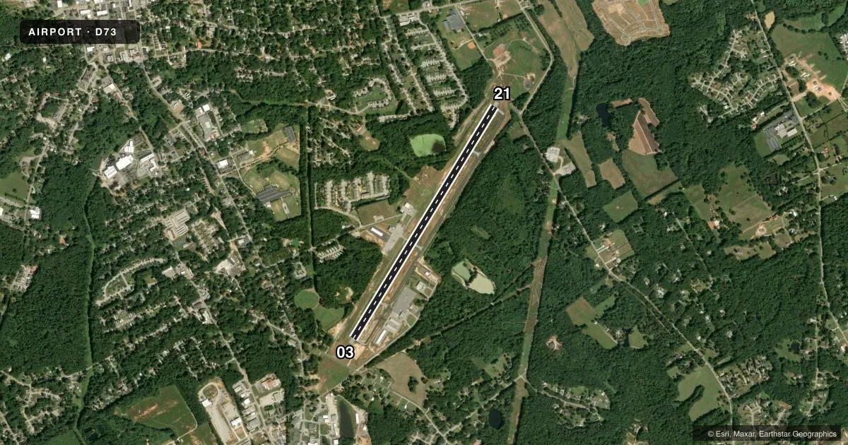
Runways & pattern
Full pagePattern entry · RWY 03
LEFT TRAFFICRunway end performance
| End | TORA | TODA | ASDA | LDA | VGSI | Approach lights | Obstruction |
|---|---|---|---|---|---|---|---|
| 03 | — | — | — | — | PAPI 2-box left(4°) | — | 86', trees, 874' from thr, 326' R of cntrln, slope 7 |
| 21 | — | — | — | — | PAPI 2-box left(3.5°) | — | 21', trees, 243' from thr, 253' R of cntrln, slope 2 |
Declared distances in feet. TORA = takeoff run available, TODA = takeoff distance, ASDA = accelerate-stop, LDA = landing distance.
Airport sketch
Runways drawn to scale from FAA survey coordinates, rendered over satellite imagery. Not for navigation.
Approaches & charts
Services on the field
Fuel grades, oxygen, maintenance, ramp storage and lighting — as declared to the FAA by the airport operator.
Fuel & services
- Fuel
- 100LL
- Oxygen (bottled)
- Not available
- Oxygen (bulk)
- Not available
- Airframe repair
- Major
- Power plant repair
- Major
- Other services
- GLD,INSTR,PAJA
Ramp & ground
- Transient storage
- Tie-down
- Landing fee
- No fee published
- Customs
- Not available
- Lighting schedule
- SEE RMK
- Beacon schedule
- SS-SR
- Beacon
- White / Green (civil land)(WG)
- Wind indicator
- Lighted
- Segmented circle
- Yes
Fuel & FBOs
Cheapest 100LL and Jet A on the field and nearby. Always confirm with the FBO before taxi.
Airport notes
Surface conditions, obstructions, local procedures, lighting outages and other notes published with each FAA cycle.
General notes
- GLIDER OPS 10 NM RADIUS SFC - 5000 FT.
- DEER ON & INVOF ARPT.
- FOR CD CTC ATLANTA APCH AT 678-364-6131.
Lighting notes
- DUSK-2200. MIRL RY 03/21 PRESET LOW INTST DUSK-2200; TO INCR INTST & ACTVT MIRL RY 03/21 AND PAPI RYS 03 & 21 AFTER 2200 - CTAF.
Approach & departure obstructions
- 031'-4' FT BERM, 1'-200' FROM THRESHOLD, 240' RIGHT OF CENTERLINE
VFR map & nearby airports
VFR sectional. Tap any ICAO chip to open that airport.
Key facts · D73
Answer card- ICAO
- D73
- Name
- CY NUNNALLY MEML
- Location
- MONROE, GEORGIA
- Elevation
- 875.2 ft MSL
- Traffic pattern altitude
- 1,875.2 ft MSL (1,000 AGL)
- Control tower
- Non-towered (use CTAF)
- Total runways
- 1
- Longest runway
- 03/21 · 5,000 ft
- Published ILS approaches
- 0
- Published frequencies
- 3
- Magnetic variation
- 4°
- Current flight rules
- VFR
- Current wind
- Calm / unavailable
- Favored runway now
- –
CY Nunnally Meml Airport is in Monroe, Georgia. The field elevation is 875.2 ft MSL. It has one runway. Runway 03/21 is 5,000 ft long with asphalt pavement. There is no control tower. No ILS approaches are published here. The pattern altitude is not published, so use the standard 1,000 ft AGL unless current published guidance says otherwise.
Fair Weather Flights is on the field. It carries 100LL. Call (770) 267-2343 before you go if you need current ramp details or fuel status. CTAF is 122.9. Atlanta Approach handles approach and departure services on 126.975 and 239.275. For clearance delivery, contact Atlanta Approach at 678-364-6131.
A few published remarks matter here. Runway 03 has a berm near the threshold, offset to the right of centerline. Runway lighting on 03/21 is preset to low intensity from dusk to 2200. After 2200, use CTAF to raise the runway lights and activate the PAPI. Glider activity occurs within 10 NM of the airport from the surface to 5,000 ft. Deer are also reported on and near the airport. Plan your arrival with that in mind, especially at night or in low light.